Technical Reports

Sample pages from various technical reports.

Reports published by the New Jersey Geological and Water Survey (NJGWS) are broken into five types: Bulletins (B), Geologic Survey Reports (GSR), Open-File Report (OFR), Technical Memorandums (TM), and Ground Water Reports (GWR).

  • Bulletins (B) present completed scientific research and analysis of wide and lasting importance.
  • Geologic Survey Reports (GSR) include summaries of investigations, overviews of current and anticipated problems, inventories, compilations, summary reports, manuals, guidebooks, and databases.
  • Open-file reports (OFR) are intended to invite comment and for release of materials which will soon be outdated or revised. These reports may also include the final products of short-term projects.
  • Technical memorandums (TM) are typically brief and are prepared in response to questions from the public, legislators, state agencies, etc.
  • Ground Water Report (GWR) has been published by NJGWS and it describes methods that can be used to estimate water supply needs and assess the adequacy of such wells.

Other data presented in NJGWS reports include, but are not limited to, geophysical and hydrogeologic investigations of particular areas of New Jersey, water quality data for particular aquifers or geographic provinces, deep well catalogs, mineral industry statistics, and directories of old aerial photographs.

A hard copy of Bulletin 77 is available for purchase for a price of $100.

The following is a list of technical reports published by the New Jersey Geological and Water Survey:

Bulletin Number Title
1  Annual Administrative Report of the State Geologist for the Year 1910
2  A Report on the Approximate Cost of a Canal between Bay head and the Shrewsbury River, 1911
3  The Flora of the Raritan Formation, 1911
4  A Description of the Fossil Fish Remains of the Cretaceous, Eocene and Miocene Formations of N. J., 1911
5  The Mineral Industry of New Jersey for 1910
6  Annual Administrative Report of the State Geologist for the year 1911
7  The Mineral Industry of New Jersey for 1911
8  Annual Administrative Report of the State Geologist for the year 1912
9  A Preliminary Report of the Archaeological Survey of the State of New Jersey, 1913
10  The Mechanical and Chemical Composition of the Soils in the Sussex Area, N.J., 1913
11  The Mineral Industry of New Jersey for 1912
12  Annual Administrative Report of the State Geologist for the Year 1913
13  Indian Habitations in Sussex County, New Jersey, 1915
14  The Geology of New Jersey, 1915
15  The Mineral Industry of New Jersey for 1913
16  Annual Administrative Report of the State Geologist for the Year 1914
17  Revision of Primary Levels and List of Bench Marks in Northern New Jersey, 1916
18  Archaeology of Warren and Hunterdon Counties (with Map), 1917
19  Additional Bench Marks in Burlington, Camden, Mercer, Middlesex and Monmouth Counties, 1918
20  Soil Survey of the Belvidere Area, New Jersey, 1920
21  List of Bench Marks in New Jersey, Revised to 1920
22  Soil Survey of the Millville area, New Jersey, 1921
23  Potash in the Greensands of New Jersey, 1923
24  Soil Survey of the Bernardsville Area, New Jersey , 1923
25  Soil Survey of the Chatsworth Area, New Jersey , 1923
26  The Mineral Industry of New Jersey for 1923
27  The Mineral Industry of New Jersey for 1924
28  Soil Survey of the Trenton Area, New Jersey, 1926
29  The Mineral Industry of New Jersey for 1925
30  Ground Water Supplies of the Atlantic City Region, 1928
31  The Mineral Industry of New Jersey for 1926
32  The Mineral Industry of New Jersey for 1927
33  Surface Water Supply of New Jersey to September 30, 1928
34  The Mineral Industry of New Jersey for 1928
35  Ground Water Supplies in the Vicinity of Asbury Park, 1930
36  Mineral Industry of New Jersey for 1929
37  Mineral Industry of New Jersey for 1930, and Preliminary Estimates for 1931
38  Ground Water Supplies of the Passaic River Valley near Chatham, NJ, 1932
39  Ground Water Supplies of the Camden Area, New Jersey, 1932
40  Mineral Industry of New Jersey for 1931
41  The Mineral Industry of New Jersey for 1932
42  Mineral Industry of New Jersey for 1933
43  Mineral Industry of New Jersey for 1934
44  New Jersey Geodetic Control Survey Bench Marks, 1936
45  New Jersey Geodetic Control Survey Bench Marks in Essex and Passaic Counties, 1937
46  Work of the New Jersey Geodetic Control Survey, 1938
47  Continuity of the Hardyston Formation in the Vicinity of Phillipsburg, New Jersey, 1940
48  New Jersey Geodetic Control Survey Bench Marks in Bergen and Hudson Counties, 1939
49  New Jersey Geodetic Control Survey Bench Marks in Camden and Burlington Counties, 1939
50  The Geology of New Jersey, 1940
51  New Jersey Geodetic Control Survey Bench Marks in Camden, Gloucester and Salem Counties, 1940
52  The Stratigraphy, Fauna and Correlation of the Vincentown Formation, 1941
53  New Jersey Geodetic Control Survey Bench Marks in Burlington, Monmouth and Ocean Counties, 1941
54  Geophysical Methods of Exploration and their Application to Geological Problems in New Jersey, 1941
55A  Peats and their Utilization – Part A: Nature and Origin of Peat. Composition and Utilization, 1942
55B  Peats and their Utilization – Part B: The Peat Resources of New Jersey, 1943
56  The Mineral Wool Industry in New Jersey, 1942
57  Copper Mines and Mining in New Jersey, 1944
58  New Jersey Geodetic Control Survey Bench Marks in Cumberland and Salem Counties, 1944
59  Bibliography and Index of the Geology of New Jersey, 1946
60  Short Geologic Papers, 1951
61  The Cretaceous fossils of New Jersey — Part II: Gastropoda, Scaphopoda, Nautiloidea, Ammonoidea, Belemnitidae, Crustacea, Vertebrata and miscellaneous fossils, 1962 (Reprinted 1991)
61-I  The Cretaceous fossils of New Jersey — Part I: Porifera, Coelenterata, Annelida, Echinoidea, Brachiopoda and Pelecypoda, 1958 (Reprinted 1991)
62  Geology of the Andover Mining District, Sussex County, New Jersey, 1952
63  Petrography and Genesis of the New Jersey Beach Sands, 1954
64  Trap Rock Minerals of New Jersey, 1960
65  The Minerals of Franklin and Sterling Hill, New Jersey 1962
66  Mapping Digest for New Jersey, 1965
67  The Story of New Jersey’s Civil Boundaries, 1606-1968
70  Caves of New Jersey, 1976
71  Proceedings of the University Seminar on Pollution and Water Resources, Vol. I, 1967-1968
72-A  Proceedings of the University Seminar on Pollution and Water Resources, Vol. II, 1968-1969
72-B  Proceedings of the University Seminar on Pollution and Water Resources, Vol. III, 1969-1970
72-C  Proceedings of the University Seminar on Pollution and Water Resources, Vol. IV, 1970-1971
72-D  Proceedings of the University Seminar on Pollution and Water Resources, Vol. V, 1971-1972
72-E  Proceedings of the University Seminar on Pollution and Water Resources, Vol. VI, 1972-1975
73  Geology and Ground Water Resources of Sussex County and the Warren County Portion of the Tocks Island Impact Area, 1974
74  Land Oriented Reference Data System (LORDS), 1974
75-A  Proceedings of the University Seminar on Pollution and Water Resources, Vol. VII, 1972-1973
75-B  Proceedings of the University Seminar on Pollution and Water Resources, Vol. VIII, 1974-1975
75-C  Proceedings of the University Seminar on Pollution and Water Resources, Vol. IX, 1975-1978
75-D  Proceedings of the University Seminar on Pollution and Water Resources, Vol. X, 1975-1978
75-E  Proceedings of the University Seminar on Pollution and Water Resources, Vol. XI, 1975-1978
75-F  Proceedings of the University Seminar on Pollution and Water Resources, Vol. XII, 1978-1979
76  Hydrogeochemistry of the New Jersey Pine Barrens, 1981
77  Contributions to the Geology and Hydrogeology of the Newark Basin, 2010
78  Subdivision of the Jutland Sequence into Formations and Members, 2022
GSR Number Title Author(s) Publication Date
1 Bedrock Map of the Hackensack Meadowlands Parrillo, Daniel G. 1959, revised by Kasabach, H.F. in 1962, reprinted 1983
2 Thirty-One Selected Deep Wells – Logs and Map Johnson, Meredith E. 1961, reprinted 1983
3 Deep Wells of the New Jersey Coastal Plain Kasabach, H. F., and Scudder, R. J. 1961, reprinted 1983
4 Generalized Structural Contour Maps of the New Jersey Coastal Plain, Richards, H. G., and others, undated, reprinted 1983 Richards, Horace G., Olmsted, F. H., and Ruhle, James L. 1962, reprinted 1983
5 Site Evaluation for Nuclear Industry, 1961 1961
6 The Ogdensburg-Culvers Gap Moraine, Sussex County Herpers, Henry 1961
7 Geology of the Ground Water Resources of Mercer County, New Jersey Widmer, Kemble 1965
8 Geology as a Guide to Regional Estimates of Water Resources, 1968 Widmer, Kemble 1968
9 Bouguer Gravity Anomaly Maps of New Jersey Bonini, William E. 1965
10 Water Resources Resume – State Atlas Sheet No. 23 Widmer, K., Kasabach, H., and Nordstrom, P. 1966
11 Geology of the Paleozoic Rocks of the Green Pond Outlier Barnett, Stockton G. 1976
12 Bibliography and Index of New Jersey Geology, 1980 1980
13 Bibliography and Index of New Jersey Geology, 1981 1981
14 Bibliography and Index of New Jersey Geology, 1982 1982
15 Asbestiform and Non-Asbestiform Amphiboles, Cadmium and Zinc in Quarry Samples from Franklin and Sparta, Sussex County, New Jersey Germine, Mark 1986
16 Geologic Research in New Jersey, 1987 1987
17 Geophysical Investigations to Determine Bedrock Topography in the East Hanover-Morristown Area, Morris County, New Jersey Ghatge, Suhas L., and Hall, David W. 1989
18 Hydraulic Properties of the Middle and Upper Aquifers of the Potomac-Raritan-Magothy Aquifer System in the Northern Coastal Plain of New Jersey Pucci, Amleto A., Jr. and Pope, Darryl A. 1989
19 Water Quality Data for the Potomac-Raritan-Magothy Aquifer System in the Northern Coastal Plain of New Jersey Harriman, Douglas A., Pope, Daryll A., Gordon, and Alison D. 1923-1986
20 Temporal Variations and Sources of Pb, Cd, Cu, Ni, Fe and Mn in Shallow Ground Water of the McDonalds Branch Basin, Lebanon State Forest, Burlington County, New Jersey Demir, Ilham 1989
21 Bibliography and Index of New Jersey Geology, 1753-1983 Harper, David P., and Yost, Kay 1989
22 Records of Selected Wells in Atlantic County, New Jersey Mullikin, Lloyd G. 1990
23 Mapping Digest for New Jersey Barker, Harold J., Jr. 1990
24 Index of New Jersey Geologic Maps, 1990 Dombroski, Daniel R., Jr. 1990
25 Inventory of Active and Abandoned Sand and Gravel Mining Operations in New Jersey Bell, Christy, Simmons, Raymond, and Behroozi, Cyrus 1991
26 A Marine Seismic Survey to Delineate Tertiary and Quaternary Stratigraphy of Coastal Plain Sediments Offshore to Atlantic City, New Jersey Waldner, Jeffrey S., and Hall, David W. 1991
27 Natural Sources of Mercury in the Kirkwood-Cohansey Aquifer System of the New Jersey Coastal Plain Dooley, John H. 1992
28 Graptolite Biostratigraphy of the Ordovician Martinsburg Formation in New Jersey and Contiguous Areas Parris, David C., and Cruikshank, Kenneth M. 1992
29 Guidelines for Preparing Hydrogeologic Reports for Water-Allocation Permit Applications, with an Appendix on Aquifer-Test Analysis Procedures (Superceded by TM 12-2 )  Hoffman, Jeffrey L., Canace, Robert, Boyle, James, Blyskun, George 1992
30 Directory of New Jersey Aerial Photography  Sass, Ken 1992
31 Catalog of New Jersey Earthquakes through 1990 Dombroski, Daniel R., Jr. 1992
32 A method for Evaluating Ground-Water-Recharge Areas in New Jersey Charles, E. G., Behroozi, C., Schooley, J., and Hoffman, J. L. 1993
33 Hydrogeologic Framework of the Middle and Lower Rockaway River Basin, Morris County, New Jersey  Canace, Robert, Stanford, Scott D., and Hall, David W. 1993
34 Ground-Water-Withdrawal and Water-Level Data for the Central Passaic River Basin, New Jersey, 1898-1990 Hoffman, Jeffrey L., and Quinlan, John 1994
35 Natural Ground-Water Quality in Bedrock of the Newark Basin, New Jersey Serfes, Michael E. 1994
36 Hydrogeology, Simulation of Regional Ground-Water Flow, and Saltwater Intrusion, Potomac-Raritan-Magothy Aquifer System, Northern Coastal Plain of New Jersey Pucci, Amletto, Jr., Pope, Daryll A., and Gronberg, JoAnn M. 1994
37 Geophysical Investigation of the Potomac-Raritan-Magothy Aquifer System and Underlying Bedrock in Parts of Middlesex and Mercer Counties, New Jersey Sanberg, Stewart K., Hall, David W., Gronberg, JoAnn M., and Pasicznyk, David L. 1996
38 Ground Water Flow and Future Conditions in the Potomac-Raritan-Magothy Aquifer System, Camden Area, New Jersey Navoy, Anothony S., and Carleton, Glen B. 1995
39 Ground-Water Quality in the Bedrock Aquifers of the Highlands and Valley and Ridge Physiographic Provinces of New Jersey Serfes, Michael E. 2004
40 Hydrostratigraphy of the Kirkwood and Cohansey Formations of Miocene Age in Atlantic County and Vicinity, New Jersey  Sugarman, Peter J. 2001
41 Ground-Water Flow and Quality in the Atlantic City 800-foot Sand, New Jersey McAuley, Steven D., Barringer, Julia L., Paulachok, Gary N., Clark, Jeffrey S., and Zapecza, Otto S. 2001
42 Borehole Geophysical Logs and Geological Interpretation of Two Deep, Open Boreholes in the Passaic Formation, Elizabeth City, Union County, New Jersey Gregory C. Herman, Mark A. French, and John F. Curran 2015
43 Garden State Mastodons Pallis, Ted 2018, revised 2019
44 Using Electrical Resistivity to Delineate Active Sinkholes at Spruce Run Recreation Area Gagliano, Michael P., and Spencer, Michelle 2020

OFR Number Title Author(s) Publication Date
83-2 Computer Analysis of Pump Test Data Hoffman, Jeffrey L. 1983
83-3 Results of the 1980-81 Drought Emergency Ground Water Investigation in Morris and Passaic Counties, New Jersey Canace, R., Hutchinson, W. R., Saunders, W. R., and Andres, K. G. 1983
83-5 Radioactive Mineral Occurrences in New Jersey Bell, Christy (compiler) 1983
84-1 New Jersey Ground Water Pollution Index September, 1974 – April, 1984 Britton, Cindy L. (Compiler) 1984
87-1 Plan of Study for the New Jersey Bond Issue Ground-Water-Supply Investigations Leahy, P. Patrick, Paulachok, Gary N., Navoy, Anthony S., and Pucci, Amleto A, Jr. 1987
88-3 Water Levels in the Principal Aquifers of Atlantic County and Vicinity, New Jersey, 1985-86 Clark, Jeffrey S., and Paulachok, Gary N. 1989
88-4 Plan of Study for the Central Passaic River Basin Hydrogeologic Investigation Hoffman, Jeffrey L. 1989
89-1 Simulated Drawdowns, 1972-1995, in the Pleistocene Buried Valley Aquifers in Southwestern Essex and Southeastern Morris Counties, New Jersey Hoffman, Jeffrey L. 1989
89-2 Reports of the New Jersey Geological Survey Dombroski, Daniel R. 1989
90-2 Gravity Base Station Network in Northern New Jersey Ghatge, Suhas L., and Jagel, Donald L. 1990
91-1 Detection of an Abandoned Mine using High-Resolution Geophysical Methods in Randolph Township, Morris County, New Jersey Ghatge, Suhas L., and Waldner, Jeffrey S. 1991
91-3 Preliminary Textural and Mineralogical Analysis of Vibracore Samples Collected Between Absecon and Barnegat Inlets, New Jersey Uptegrove, Jane, Grosz, Andrew E., Maharaj, Susan V., Muller, Frederick L., Muessig, Karl, Farnsworth, John, Burbanck, George P., and Cheung, Tin-Tung 1991
92-1 The Palisades Sill and Watchung Basalt Flows, Northern New Jersey and Southeastern New York: A Geological Summary and Field Guide Puffer, John H., Husch, Jonathan M., and Benimoff, Alan I. 1992
92-2 Field Guide to the Geology of Radon Hazard Areas in New Jersey Muessig, Karl, Houghton, Hugh, Monteverde, Donald, and Volkert, Richard 1992
92-3 Plan to Evaluate the Hydrogeology of the Valley-Fill and Carbonate-Rock Aquifers near Long Valley in the New Jersey Highlands  McAuley, Steven D., Nicholson, Robert S., Barringer, Julia L., and Blyskun, George J. 1992
93-1 Well Interference and Evidence of Fracture Flow in the Passaic Formation near Pennington, Mercer County, New Jersey Boyle, James T. 1993
95-1 Characterization of Offshore Sediments in Federal Waters as Potential Sources of Beach Replenishment Sand – Phase 1 Uptegrove, Jane, Mullikin, Lloyd G., Waldner, Jeffrey S., Ashley, Gail, Sheridan, Robert E., Hall, David W., Gilroy, James T., and Farrell, Stewart C. 1995
95-2 Geographic Information System (GIS) database Development for the Central Passaic River Basin Hydrogeologic Investigation French, M. A. 1995
00-1 New Jersey Water Withdrawals 1990-1996 Hoffman, Jeffrey L. and Lieberman, Steven E. 2000
03-1 OFR 03-1, Guidelines for Delineation of Well Head Protection Areas in New Jersey Spayd, Steven E. and Johnson, Stephen W. 2003
04-1 OFR 04-1, A Recharge-Based Nitrate-Dilution Model for New Jersey Hoffman, Jeffrey L. and Canace, Robert J. 2004
04-2 OFR 04-2, Development of Streamflow and Ground-Water Drought Indicators for New Jersey Hoffman, Jeffrey L. and Domber, Steven E. 2004
08-1 Ground Water Recharge in the New Jersey Highlands Hoffman, Jeffrey L. and Mark A French 2008
11-1 Expansion of Monitoring Well Network in Confined Aquifers of the NJ Coastal Plain, 1996-1997 Mullikin, Lloyd 2011
13-1 History of Passing Flows in New Jersey, with Contemporary and Future Applications Hoffman, Jeffrey L. and Domber, Steven E. 2013
15-1 Potable Water Supplied in 2011 by New Jersey’s Highlands Desai, Foram, Domber, Steven, and Snook, Ian 2015
16-1 Hydrogeologic Framework and Computer Simulation of Groundwater Flow in the Valley-Fill and Fractured-Rock Aquifers of the Germany Flats Area of Sussex County, New Jersey Nicholson Laura J. 2016
20-1 The Geology, History, and Industry of the Fish House Clay of Camden County Kosar, Corinne 2020
20-2 Measurement of Background pH In Selected, Potential Acid-Sulfate Producing Sediments of The Coastal Plain Of New Jersey Dooley, John H. 2020
21-2 Efficacy Of Using Marine Seismic Data To Map The Potential Use Of Offshore Sheet Sands For Beach Replenishment In New Jersey Gagliano, Michael P. 2022
21-3 Springs of New Jersey
(Digital data found in DGS18-1)
Pallis, Ted, Domber, Steven E., Bousenberry, Raymond, Filo, Rachel, Strakosch Walz, Kathleen, Caraballo, Yaritza Acosta, Wu, Meiyin 2022
21-4 New Jersey Amber Kosar, Corinne, Green, Cailey, and Pallis, Ted 2024
TM Number Title Author(s) Publication Date
A set of SAS programs for ground water pollution site management data  J.L. Hoffman 1985
Brief History of the New Jersey Geological Survey, D.R. Dombroski D.R. Dombroski, Jr. 1984
Evaluation of aquifer quality in N.J. in terms of criteria established by the Underground Injection Control (UIC) Program Garry Morrison and Robert Canace 1983
Landfill leachate flux equations: a theoretical development and computer programs J.L. Hoffman 1984
Review of the permeability characteristics of the Woodbury Clay D. R. Dombroski 1985
The Noordbergum effect  J. L. Hoffman 1984
TIP: a Theis interactive program J. L. Hoffman 1984
87-3 Ground water contamination and the delineation of a well restriction area in East Hanover Township, Morris County, N.J. Gil Oudijk 1987
87-4 Water soluble phase of number 2 fuel oil: results of a laboratory mixing experiment W.H. Kramer and T.J. Hayes
87-5 Water soluble phase of gasoline: results of a laboratory mixing experiment W.H. Kramer and T.J. Hayes 1987
88-1 Seismic refraction and gravity investigation of topography at Lakeland Regional High School, Wanaque, Passaic County, New Jersey Thomas C. Bambrick and Donald Jagel 1988
88-2 Hydrogeologic study of water well failures in argillite bedrock of Sourland Mountain, Somerset County, New Jersey Hugh F. Houghton 1988
88-5 Seismic refraction and electrical resistivity surveys, West Milford Township, Passaic County, New Jersey Jeffrey S. Waldner, Thomas C. Bambrick, and John C. Groenewold 1988
89-1 Annual summary of phytoplankton blooms and related conditions in New Jersey coastal waters, summer of 1988 Paul Olsen and Barbara Kurtz 1989
89-2 Determination of bedrock topography and geology using various geophysical techniques Suhas L. Ghatge, David L. Pasicznyk, Stewart K. Sandberg, David W. Hall, and John C. Groenwold 1989
98-1 Comprehensive Chemistry of Select Greensand from the New Jersey Coastal Plain John H. Dooley 1998
99-1 Basin Factor Calibration for Ground-Water Recharge Estimation Hoffman, Jeffrey L. 1999
01-1 Development of New Jersey Drought Regions Hoffman, Jeffrey L. 2001
04-1 Modifications to New Jersey’s Watershed Management Area Boundaries, 1996-1999 Hoffman, Jeffrey L. 2004
06-1 Field Tests Using a Heat-Pulse Flow Meter to Determine its Accuracy for Flow Measurements in Bedrock Wells Herman, Gregory C. 2006
09-1 Potential Rate of Stream-Base-Flow Depletion from Groundwater Use in New Jersey Canace, Robert C. and Hoffman, Jeffrey L. 2009
09-2 Revisions to New Jersey’s HUC 14s, 2009, with a Correlation to HUC 12s Hoffman, Jeffrey L. and Ted Pallis 2009
09-3 The Hydroecological Integrity Assessment Process in New Jersey Hoffman, Jeffrey L. and Helen Rancan 2009
10-1 Reconstructed Streamflow in the Musconetcong River at Lake Hopatong Hoffman, Jeffrey L. 2010
12-1 Results of an Aquifer Test in Chatham Borough, Morris County, New Jersey Hoffman, Jeffrey L. 2012
12-2 Hydrogeologic Testing and Reporting Procedures in Support of NJ Water Allocation Permit Applications (Supercedes GSR 29) Hoffman, Jeffrey L., Petriman, Ovidiu, Bleicher, Mike, Boyle, Jim, Domber, Steven, French, Mark, Gheen, Jan, Johnson, Steve, Mennel, Bill, Myers, Jennifer, Nicholson, Laura, Rancan, Helen, Roman, Eric, and Shim-Chin, Richard 2012
13-1 New Jersey Water Supply Planning Activities in 2012 Hoffman, Jeffrey L. 2013
13-3 Using the Stream Low Flow Margin Method to Assess Water Availability in New Jersey’s Water-Table-Aquifer Systems Steven Domber, Ian Snook, and Jeffrey L. Hoffman 2013
13-4 Changes in Groundwater Recharge Resulting from Development in Atlantic, Mercer and Sussex Counties, New Jersey, 1995-2007 Thompson, Charles and Hoffman, Jeffrey L. 2013
14-1 Nitrate Concentrations in Groundwater of New Jersey’s Highlands Hoffman, Jeffrey L. and Petriman, Alexandra 2014, updated and revised 2015
16-1 Protocol for Heavy-Liquid Separation of Heavy Minerals and Recovery of Non-Toxic Separation Liquids Uptegrove, Jane, Reier, Sandra A. and Muller, F.L. 2016
17-1 Highest Elevations by County in New Jersey Alexandra Petriman 2017
18-1 Reservoir Operations in New Jersey Preceding Hurricane Sandy, October, 2012 Hoffman, Jeffrey L. 2018
21-1 Investigation of Elevated Sodium and Chloride in Well Water, Village of Columbia, Knowlton Township, Warren County, New Jersey Brady Lubenow, Michael Gagliano, Michelle Spencer, Raymond Bousenberry, and Steven Spayd 2022

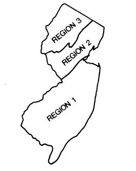
The following report describes a method developed by the New Jersey Geological Survey to estimate the water supply needs of private homes and to evaluate the adequacy of wells drilled to supply those households. This method consists of a calculation to estimate total daily needs and peak demand needs of a household and a two-part pumping test to determine whether or not a well can meet these needs. This procedure is intended primarily for use in areas of consolidated bedrock (Regions 2 and 3 of the New Jersey water well construction regulations (N.J.A.C. 7:10-35).

GWR Number Title Author(s) Publication Date
1 Two-Part Pump Test for Evaluating the Water Supply Capabilities of Domestic Wells Canace, Robert, and Hoffman, Jeffrey L. 1986
Geologic regions of New Jersey as defined in water well construction regulations, N.J..A.C. 7:10-35 (Figure 1 from report number 1 of the ground-water report series).