Historical Maps
Data presented in these historical maps include, but are not limited to, abandoned mines layouts, geologic interpretations, and topographic information. The following is a list of historical maps archived by the New Jersey Geological & Water Survey:
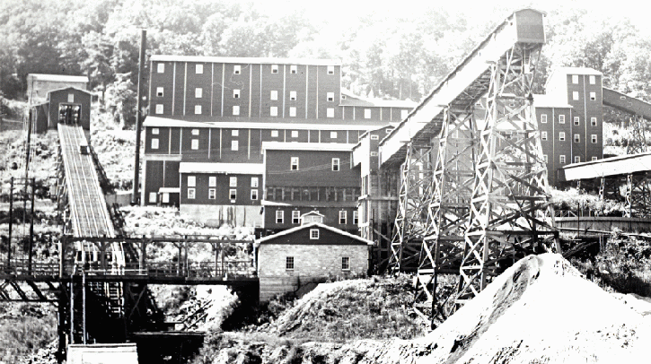
The mining industry of New Jersey dates back to the 1600’s when copper was first mined by Dutch settlers along the Delaware River in Warren County. One of the first iron mines in the United States was located, around 1710, in the Mt. Hope section of Rockaway Township, Morris County. There are approximately 450 underground mines in New Jersey, all of which are now abandoned. In many cases, very little information was compiled regarding the mines. The New Jersey Geological and Water Survey (NJGWS) has scanned the mine maps in its collection and acquired other maps making them available for download as Adobe ™ PDF documents. The maps in this collection are from mines in the northern half of the state in 9 of the 10 counties where all of the underground mining activities in New Jersey took place. The counties represented in this collection are Sussex, Warren, Morris, Bergen, Hunterdon, Passaic, Middlesex, Somerset and Union. There are no maps from Essex County in this collection. Mine maps can be important in the remediation of any subsidence or collapse events, pollution tracking and remediation, historical research, land development and open space purchases.
Currently, in the Survey archives, there are 622 published and unpublished mine maps that date from around 1867 to 1983. These maps of the mines include plan views of surface and subsurface workings as well as profiles of the workings. Some of the maps contain magnetic surveys, boring locations and or boring information and may depict local geology and ore seams. Some show cultural features and land holdings in the area of the mines. Many are copies of original maps of varying dates. The information contained on the maps may or may not be accurate or to scale.
Images of the mine maps have been created by scanning the maps on a large format scanner at a resolution of 300 dpi using RGB color to tiff images. The tiff images were then converted to Adobe™ PDF documents. These mine maps are available for download from the list below. Many other mine maps were originally published as parts of NJGS reports. These reports are available as online Adobe™ PDF documents. The mine maps in these reports can be accessed through links to the reports. Source information for many of the scanned mine maps is also available in this list.
New Jersey Statewide and Regional Mine Maps
Mine Processing Flow Sheets
A list of map references and links to additional mine maps are available.
Maps by county
| Bergen County | |
| North Arlington Boro | Schuyler/Arlington Copper Mine |
| Hunterdon County | |
| Bethlehem Township | Henry Tunnel Mine Turley hill and Swayze Mine |
| Flemington Boro | Flemington Copper Mine |
| High Bridge Boro | Wildcat and Van Syckles Mines |
| Middlesex County | |
| New Brunswick City | New Brunswick Copper Mine |
| Passaic County | |
| Ringwood Boro | Ringwood Area Mines |
| Somerset County | |
| Franklin Township | Griggstown Copper Mine |
| Somerville Boro | Somerville Copper Mine |
| Sussex County | |
| Andover Township | Andover, Sulpher Hill |
| Byram Township | Allis Exploration, Silver Mine Bemco Prospect – Charolette Mine Cascade Mine District French’s Mine |
| Franklin Boro | Franklin Mines Franklin Mines, Trotter – Taylor Mines Franklin Mines, Property – Tax Maps Franklin and Sterling Hill Mines, Exploration Maps |
| Hamburg Boro | Hamburg Mines |
| Ogdensburg Boro | Sterling Hill Mines |
| Sparta Township | Edison Mines, Cross Sections Edison Mines, Cross Sections with Drill Holes Edison Mines Maps Linn Lott Property Ogden Mine |
| Vernon Township | Welling Mine Pochuck Mine |
| Union County | |
| N/A | Copper Mine, Watchung Reservation |
| Warren County | |
| Allamuchy Township | Haggerty Farm and Shields Mines Waterloo Mine |
| Hardwick Township | Pahaquarry Mine |
| Hope Township | Hoit Mine |
| Independence Township | Barker Mine Frederick Francis Mine Property Green Farm Exploration Howell Mine Mt. Bethel Area Dip Needle Surveys Potter Farm Mine Schaefer Farm Exploration Searle Mine Scranton Lease Exploration Stinson Mine Cummins Mine |
| Oxford Township | Ahles Mine Pequest Mines Queen Mines Oxford Mines |
| White Township | Barton Mine Kaiser Mine Shoemaker Mine |
New Jersey State Atlas Sheets were completed by Topographic Engineer C.C. Vermeule. For conservation purposes, the Atlas Sheets were encapsulated in archival mylar. After encapsulation, each map was scanned in TIFF format at least 300 dpi as RGB datatype and converted to an Adobe™ PDF document (see below) to include all of the image features within and outside the New Jersey State boundaries. Some of the maps were scanned from copies on file at the “NJ State Archives; Department of State”.
Atlas Sheets 1-20
These historical Atlas Sheets, in Adobe™ PDF format are the originals of Vemuele’s work and comprise the first sets of seventeen Atlas Sheets including overlapping (Nos. 1-17 from 1885-1902) at a scale of 1 to 63,360 (1 inch = 1 mile). Also included are three statewide maps numbered 18, 19 and 20, and an index map.
| Atlas Sheet Number | Atlas Sheet Name | Years |
| 1 | Kittatinny Valley and Mountain | 1886 , 1888 , 1889 , 1894 |
| 2 | Southwestern Highlands | 1885 , 1889 , 1890 |
| 3 | Central Highlands | 1884 , 1888 , 1889 , 1898 |
| 4 | Northeastern Highlands | 1884 , 1888 , 1889 , 1890 |
| 5 | Vicinity of Flemington | 1887 , 1888 , 1889 |
| 6 | The Valley of The Passaic | 1885 , 1888 , 1889 , 1890 , 1894 , 1900 |
| 7 | Bergen, Hudson and Essex | 1884 , 1888 , 1889 , 1890 , 1896 |
| 8 | Vicinity of Trenton | 1887 , 1888 , 1889 , 1894 |
| 9 | Monmouth Shore | 1886 , 1888 , 1889 , 1890 , 1902 |
| 10 | Vicinity of Salem | 1887 , 1889 |
| 11 | Vicinity of Camden | 1887 , 1888 , 1889 , 1894 , 1896 |
| 12 | Vicinity of Mount Holly | 1887 , 1888 , 1889 , 1895 |
| 13 | Vicinity of Barnegat Bay | 1886 , 1888 , 1889 , 1891 |
| 14 | Vicinity of Bridgeton | 1887 , 1889 , 1890 |
| 15 | Southern Interior | 1887 , 1889 , 1890 |
| 16 | Egg Harbor and Vicinity | 1885 , 1888 , 1889 , 1891 |
| 17 | Peninsula of Cape May | 1886 , 1888 , 1889 , 1895 |
| 18 | The State of New Jersey | 1890 |
| 19 | New Jersey Relief Map | 1888 , 1889 , 1892 |
| 20 | Geological Map of New Jersey | 1889 , 1890 |

Atlas Sheets 21-42
These historical Atlas Sheets, in Adobe™ PDF format, are the final revisions of Vemuele’s work and comprise seventeen contiguous Atlas Sheets (Nos. 21-37) at a scale of 1 to 63,360 (1 inch = 1 mile) and date from 1903-1976. This series also includes statewide Atlas Sheets 38-42 at a scale of 1:250,000 (1 inch = about 4 miles). Atlas Sheet 38 consists of Boroughs and Towns of New Jersey, Atlas Sheet 39 has County and Municipality Map of New Jersey, Atlas Sheet 40 has Geologic Map of New Jersey, Atlas Sheet 41 has Railroad Map of New Jersey, and Atlas Sheet 42 has Road Map of State of New Jersey.
| Atlas Sheet Number | Years |
| 21 | 1906 , 1913 , 1926 , 1946 , 1959 |
| 22 | 1903 , 1910 , 1916 , 1928 , 1933 , 1939 , 1947 , 1960 |
| 23 | 1903 , 1910 , 1916 , 1924 , 1933 , 1947 , 1963 |
| 24 | 1903 , 1912 , 1921 , 1930 , 1936 , 1948 , 1976 |
| 25 | 1906 , 1912 , 1917 , 1928 , 1933 , 1940 , 1954 , 1974 |
| 26 | 1903 , 1908 , 1912 , 1916 , 1922 , 1927 , 1932 , 1942 , 1955 |
| 27 | 1903 , 1913 , 1926 , 1930 , 1943 , 1959 |
| 28 | 1904 , 1912 , 1917 , 1929 , 1932 , 1937 , 1949 , 1957 |
| 29 | 1910 , 1914 , 1924 , 1931 , 1938 , 1950 , 1972 |
| 30 | 1910 , 1926 , 1934 , 1951 |
| 31 | 1903 , 1913 , 1925 , 1931 , 1942 , 1958 |
| 32 | 1903 , 1923 , 1929 , 1934 , 1941 , 1955 , 1970 |
| 33 | 1905 , 1913 , 1925 , 1929 , 1937 , 1953 |
| 34 | 1910 , 1927 , 1936 , 1956 |
| 35 | 1907 , 1917 , 1930 , 1946 , 1963 |
| 36 | 1907 , 1916 , 1934 , 1945 , 1960 |
| 37 | 1905 , 1913, 1929 , 1936 , 1952 |
| 38 | 1906 |
| 39 | 1915 , 1918 , 1925 , 1932 , 1942 , 1956 |
| 39A | 1963 |
| 40 | 1912 , 1918 , 1931 , 1950 |
| 41 | 1915 |
| 42 | 1916 , 1922 , 1925 , 1933 |

Vermeule Maps
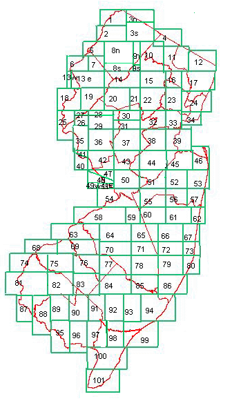
These Adobe™ PDF files of Historical topographic manuscript maps were completed by Topographic Engineer C.C. Vermeule from around 1870 to 1887 at a scale of 1 to 21,120 (3 inches equal one mile). The maps constitute New Jersey’s first topographic survey, and show early topographic interpretations and cultural features of the state. For conservation purposes, Vermeule’s maps were encapsulated in archival mylar. After encapsulation, each map was scanned in TIFF format at 300 dpi as RGB datatype and converted to JPEG format. The JPEG image was then converted to an Adobe™ PDF document. There are 101 topographic maps in the series and one key map. Maps numbered 50 and 53 are missing from the archive and were scanned from blue line field copies. Due to equipment limitations, some maps were scanned in two sections and are identified with the letter “n”, “s”, “e” or “w”.
The reference map and the original keymap show the locations of the historical topographic manuscript maps in New Jersey. Click the corresponding number below to see these individual topographic maps completed by C.C. Vermeule:
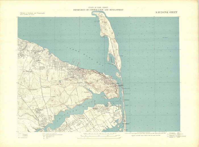
New Jersey Topographic Name Sheets were completed for selected (mostly urban areas) of New Jersey by the New Jersey Geological Survey from 1899 to 1944. All of the 63 maps in this historic series were scanned for this online collection. The scale is 1:24,000 (1 inch = 2000 feet). For conservation purposes during scanning, the Topographic Name Sheets were encapsulated in archival mylar. After encapsulation, each map was scanned in TIFF format at 400 dpi as RGB datatype. Each TIFF image was first converted to a JPEG image and then to an Adobe™ PDF document to include all of the image features within and outside the New Jersey State boundaries. The Adobe™ PDF images can be viewed and downloaded by clicking on the list below to the left for each Topographic Name Sheet.
| Name Sheet | Years |
| Amboy | 1901 , 1922 , 1940 |
| Atlantic City | 1902 |
| Boonton | 1904 , 1905 , 1927 , 1932 |
| Camden | 1899 |
| Chester | 1905 , 1915 , 1930 |
| Dover-Stanhope | 1905 , 1916 , 1932 |
| Elizabeth | 1900 , 1919 , 1930 |
| Hackensack | 1899 , 1914 , 1934 |
| Jersey City | 1899 , 1919 , 1928 |
| Long Branch | 1901 , 1931 |
| Morristown | 1902 , 1917 , 1926 , 1939 |
| Mount Holly | 1900 |
| Navesink | 1901 , 1932 |
| Newark | 1899 , 1908 , 1914 , 1926 , 1937 |
| New Brunswick | 1903 , 1905 , 1914 , 1928 , 1939 |
| New York Bay | 1903 , 1907 , 1942 |
| Paterson | 1899 , 1912 , 1922 , 1929 |
| Plainfield | 1916 , 1928 , 1938 |
| Pluckemin | 1905 , 1917 , 1944 |
| Shark River | 1903 , 1916 |
| Somerville | 1905 , 1920 , 1944 |
| Taunton | 1900 |
| Trenton East | 1902 |
| Woodbury | 1900 |
This statewide geologic map of New Jersey was compiled from published folios and from manuscript data in possession of the Survey that includes field work performed by W.S. Bayley, H.B. Kummel, R.D. Salisbury, and G.N. Knapp. Compilation was completed by J. Volney Lewis and Henry B. Kummel in 1910-1912 but then was revised in 1931 by H.B. Kummel, and again in 1950 by Meredith E. Johnson. Map scale is 1:250,000 (approximately 4 miles to one inch).

This population map is based on data obtained from the U.S. coast survey records, N.J. geological and topographical surveys, and various local surveys. It was compiled and drawn by Geo W. Howell, C.E and has a scale of 6 miles to one inch.

These maps were drawn from a survey made in 1769 by order of the commissioners appointed to settle the partition line between the Provinces of New York and New Jersey and a survey of the Northern Parts in the possession of the Earl of Dunmon. Maps were published in December of 1777.

