
Total Maximum Daily Loads (TMDLs)
The federal Clean Water Act requires each State to address impaired, “unhealthy” waterbodies through Total Maximum Daily Loads. TMDLs diagnose the source of the problem and quantify the water quality recovery, assisting DEP in achieving its priorities of waters that are swimmable, fishable and safe for drinking.
Pollutant sources, which are the cause of these unhealthy waters, fall into two categories – point sources and nonpoint sources.

Point Sources
- Municipal wastewater treatment plant discharges
- Industrial wastewater treatment plant discharges
- Residential and urban storm-water runoff*
* This source could fall in either category; however, as per the Clean Water Act storm-water runoff is regulated as a point source.
Nonpoint Sources
- Excess fertilizer from residential or agriculture run-off
- Oil, grease and toxic chemicals from urban run-off
- Sediment from construction sites, crop and forest land
- Salt from irrigation or de-icing
- Bacteria from animal waste
- Atmospheric deposition

Waters of the state are regularly assessed to determine if surface water quality standards are met and designated uses are supported. Waters that do not meet the applicable standard(s) or support the applicable designated use(s) are placed on the 303(d) List of Water Quality Limited Waters (303(d) List), as part of New Jersey’s biennial Integrated Water Quality Assessment Report. Section 303(d) of the federal Clean Water Act requires development of a TMDL for the pollutant(s) causing the impairment. Impaired waters are ranked and prioritized for TMDL development as part of the development of the 303(d) List every two years.
The factors considered in TMDL ranking and prioritization are described in the Integrated Water Quality Assessment Methods. Federal regulations concerning TMDLs are contained in USEPA's Water Quality Planning and Management Regulations (40 CFR 130,7(c)). New Jersey’s rules regarding TMDLs are set forth in the Water Quality Management Planning rules at N.J.A.C. 7:15-5.
Many of the waters placed on New Jersey's 303(d) List are impaired primarily by nonpoint sources of pollution or regulated stormwater sources rather than traditional point sources. For these impairments, development of a watershed restoration plan or watershed based plan can be an effective alternative to a formal TMDL. These plans characterize pollutant sources, the reductions needed to attain standards and the means to achieve the reductions. Implementation of these plans can often be achieved through receipt of Water Quality Restoration Grants for Nonpoint Source Pollution.
A load reduction target must be established for each pollutant listed as a cause of water quality impairment on the 303(d) List. A TMDL can include multiple load reductions but a separate TMDL equation must be derived for each pollutant causing water quality impairment. TMDLs must be calculated so that surface water quality standards for each pollutant will be attained. The critical condition and seasonal variation need to be considered, plus a margin of safety (MOS) to account for uncertainty, are all part of the TMDL development. The TMDL is allocated among all of the sources of the pollutant, including point sources, nonpoint sources and natural background.
Point sources are any discernible, confined, and/or discrete conveyance from which pollutants are or may be discharged, such as wastewater treatment facilities, combined sewer overflows and/or stormwater. All point sources receive wasteload allocations (WLAs) as part of the TMDL.
Nonpoint sources (NPS) of pollution are diffuse sources, such as overland runoff and air deposition, other than a point source from which pollutants are or may be discharged or harbor other activity that contributes or may contribute to water pollution. NPS receive Load Allocations (LAs) as part of the TMDL.
A Margin of Safety (MOS) is also required as part of the TMDL but it can be expressed as either an explicit part of the TMDL equation or may be accounted for through conservative assumptions made in calculating the TMDL. Reserve Capacity is an optional TMDL component included as a pollutant load for later allocation.
Total Maximum Daily Load = LAs + WLAs+ MOS + RC*
LA = Load allocations from nonpoint sources
WLA = Waste load allocations from point sources
MOS = Margin of saftey to account for scientific uncertainty
*RC = Reserve capacity set aside for future development (optional TMDL component)
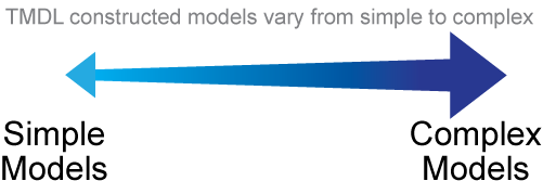
Mathematical models are used to simulate water quality conditions throughout the impaired waterbody and its watershed, including the sources of pollutants, the relationship between pollutant loading and the water chemistry and other environmental responses resulting in water quality impairment. The model is also used to evaluate pollutant reduction scenarios and waterbody response to these scenarios. The selection and application of an appropriate model leads to scientifically-defensible, TMDL-assigned pollutant reductions. There are different types of mathematical models that vary in the level of complexity:
Simple models calculate the percent reduction of pollutants neccessary to meet Surface Water Quality Standards without a need to mimic pollutant changes in the environment and are sometimes adequate for a TMDL.
Complex models can simulate changes in pollutant concentrations and flow in the contributing drainage area. Pollutant transformation and relationships to other pollutants in the area are often mimicked in complex water quality modeling.
The figure below shows an example of a (complex) model calibration figure for in-stream dissoved oxygen from the Raritan River TMDL technical report (Kleinfelder/Omni 2013, Vol. 3, pg. K-20 )

- Verify the water quality impairment
- Analyze water quality data in the watershed
- Collect additional data if needed (e.g. stream water quality data, stream characteristic measurements, weather data, etc.)
- Present information on water quality impairment and seek input from stakeholders
- Construct and test the TMDL model
- When there is a good model fit, run the TMDL model for different pollutant reduction scenarios
- Select appropriate reductions to meet the water quality standard under modeled critical waterbody conditions
- Convene a Model Evaluation Group appropriate to review complex models to vet that constructed/validated models are ready for TMDL proposal
- Propose TMDL to the Water Quality Management Plan
- Public review of proposed TMDL report
- Submit final TMDLs to USEPA for approval
- Adopt TMDL as a Water Quality Management Plan amendment
- Implement TMDLs through New Jersey Pollutant Discharge Elimination System permit revisions and grant restoration projects
- A TMDL is "proposed" when DEP publishes the TMDL Report as a proposed Water Quality Management Plan amendment in the New Jersey Register for public review and comment in accordance with N.J.A.C. 7:15-3.4
- Following the public comment period, DEP prepares a response to comments and minor revisions to the TMDL
- The revised document with response to comments is “established” upon submittal to EPA for review
- Following EPA’s review and approval process, the TMDL is deemed “approved.” DEP can then implement the TMDL and it can proceed to be “adopted” as an amendment to the Water Quality Management Plan, in accordance with N.J.A.C. 7:15-3.4
- The Notice of Adoption is published in the New Jersey Register
There are various informed opportunities during the development of a TMDL for public participation. Public meetings may be held to present information and solicit feedback. Additionally, formal public comments are sought when a TMDL is proposed - either in person at a hearing, in writing or both.
To stay up to date on public meetings join our DEP Email List and select WRM-Water Quality Assessment/Standards/Total Maximum Daily Loads.
Public participation, by stakeholders, is a valuable part of TMDL development and can be beneficial at various stages throughout the process. For example, local knowledge of water quality conditions and/or potential pollutant sources can influence TMDL monitoring designs. In addition, local water monitoring data can assist in developing a more accurate water quality model. Stakeholder input during the TMDL publication phase can help refine the final report as well as identify appropriate fixes to improve and restore water quality.
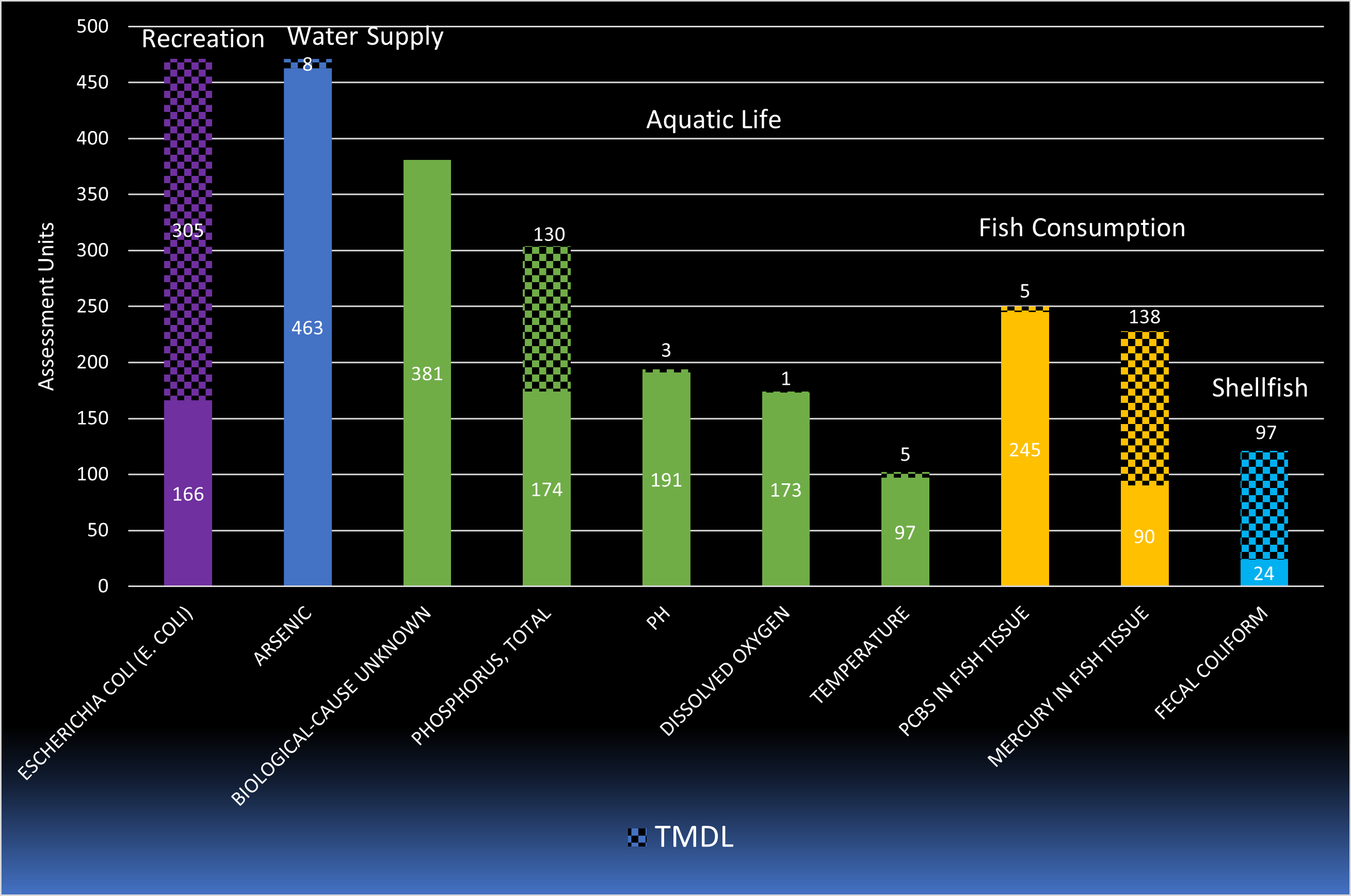
Over 600 TMDLs are covered in 50 TMDL documents that have been developed in New Jersey. The pollutants addressed by these TMDLs include pathogens, total phosphorus, mercury, PCBs, and various other pollutants described below and in the New Jersey TMDL List.
The top ten causes of water quality impairment in 2020 are shown in the chart below. Of all causes of impairments, five of the top ten are associated with the aquatic life designated use, including total phosphorus. TMDLs have been established for 68% of the pathogens, 65% of the mercury and 41% of the total phosphorus causing impairment.
Pathogen TMDLs have been developed for most of the watersheds assessed as not supporting the shellfish harvest for consumption use (79%). See the maps below for additional information.


Click on map to enlarge
 *Footnote: Use impairment is explained further HERE.
To find out what TMDLs are in your area use the TMDL look-up tool and enter the county and municipality of interest.
To view a map of areas covered by a TMDL use the DEP’s NJ-GeoWeb. Select the “TMDL” layers found in the table of contents.
DEP also provides TMDL shapefiles for download from the NJDEP Open Data (arcgis.com). Select the appropriate layer available in the dropdown on DEP Digital Data Downloads in ArcGIS Shape file format.
A TMDL Look-Up Tool is also available that allows the user to quickly identify if an approved TMDL is associated with surface waters within or bordering their municipality. This tool was developed to help municipal stormwater coordinators implement requirements of municipal separate storm sewer (MS4) permits but may be used by anyone with an interest in water quality in New Jersey.
Barnegat Bay
In 2010 the New Jersey Department of Environmental Protection (NJDEP) initiated a water quality study and monitoring program to determine more rigorous water quality standards in Barnegat Bay, the purpose of which was to,
- Evaluate water quality and determine the location and extent of impairments,
- Calibrate and validate modeling tools that can be used to simulate the condition and direct TMDL development for the Bay, and
- Based on responses to pollutant loads and water quality targets, identify load reductions from various sources and guide the restoration.
As a result of this initiative, the NJDEP has developed a site-specific nitrogen water quality standard for Barnegat Bay. The water quality standard will be achieved through a TMDL which establishes the nonpoint source load reductions needed throughout the watershed to achieve the target nitrogen water quality standard in the Bay.
A Model Evaluation Group was engaged in 2019-2020 to provide an independent and objective review for determining the adequacy of calibration, strengths and weaknesses of the calibrated model and subsequent usability of the model for TMDL and site-specific criteria development and other NJDEP management decisions. They concurred that the model served as a reasonable representation of spatial and temporal distributions of salinity, nutrients, and Chlorophyll a.

In collaboration with Barnegat Bay partners, information sessions were held as informal open forums for public participation in advance of proposing the TMDL for formal public comment.
- Session 1 Setting the Stage – An Overview of the Barnegat Bay Initiative to Develop a Rigorous Water Quality Standard for Nitrogen through Total Maximum Daily Load Process
Wednesday, Nov. 29, 2023; 9:00 a.m.–12:00 p.m.
Ocean County College, Gateway Bldg. Lecture Hall
A video recording of Session 1 has been posted at:https://youtu.be/i4tVfbh7Kikand the recording link has also been added to the event calendar notice on the DEP website:
- Session 2 Establishing a New Pollution Budget for Barnegat Bay: The Science Behind Developing the Nitrogen Standard and Modeled Load Reductions
Wednesday, January 31, 2024; 9:30 a.m. – 12:00 p.m.
Ocean County College, Gateway Bldg. Lecture Hall
LINK HERE (Coming Soon)
Additional information on a TMDL Implementation Information Session and proposal of the TMDL for public comment will be updated here in the months to come.
Watershed Based Plans
Watershed-based planning helps address water quality problems in a holistic manner by fully assessing the contributing causes and sources of pollution, then prioritizing restoration and protection strategies to address these problems. Beginning in State Fiscal Year (SFY) 2006, the Department supported development of Watershed Restoration and Protection Plans, also referred to as Watershed-Based Plans (WBPs), that focused on reducing nonpoint sources (NPS) of water pollution.
Designated use impairments caused by a parameter associated with NPS pollution that is addressed under one of these approved WBPs are identified on Subpart 5R of the Integrated List. Subpart 5R identifies use impairment caused primarily by NPS pollution or stormwater runoff that is not regulated under the federal CWA and is most effectively addressed through source controls rather than TMDLs. Watershed restoration plans, including 319(h) funded WBPs, can be an effective alternative to a formal TMDL to characterize pollutant sources, the reductions needed to attain standards, and the means to achieve the reductions. Technical guidance and related documents are available under Technical Support Documents.
- Identify causes and sources of pollution
- Estimate pollutant loading into the watershed and the expected load reductions
- Describe management measures that will achieve load reductions and targeted critical areas
- Estimate amounts of technical and financial assistance and the relevant authorities needed to implement the plan
- Develop an information/education component
- Develop a project schedule
- Describe the interim, measurable milestones
- Identify indicators to measure progress
- Develop a monitoring component
Additional information regarding developing a watershed-based plan can be acquired from EPA’s Handbook for Developing Watershed Plans to Restore and Protect Our Waters. Specific information, from that handbook, on the 9 elements above.

-
Map Key
 Alexauken Creek Watershed Plan
 Assiscunk Creek Watershed Plan
 Cedar Grove Watershed Plan
 Clove Brook Watershed Restoration Plan
 Long Swamp Creek Watershed Restoration Plan
 Manalapan Watershed Restoration Plan
 Metedeconk Watershed Plan
 Mulhockaway Creek Watershed Restoration Plan
  Neshanic River Watershed Restoration Plan
 Papakating Creek Watershed Restoration Plan
 Pleasant Run & Holland Brook Watershed Restoration Plan
 Sidney Brook Protection Plan
 Sourland Mountain Watershed Plan
 Tenakill Brook Watershed Restoration
 Upper Cohansey River Watershed Plan
 Upper Salem River Watershed Plan
 Wreck Pond Plan
Nonpoint Source Pollution Management
Addressing nonpoint sources (NPS) is a critical piece in the restoration efforts in the State. The NPS Management Program combines regulatory controls, non-regulatory strategies, watershed-based plans, restoration actions, and targeted funding to address NPS pollution. Every five years the program’s objectives and initiatives are updated in its Program Plan.
Many of the waters placed on the 303(d) List are impaired primarily by nonpoint sources of pollution and regulated stormwater sources. For these impairments, development of a watershed restoration plan or watershed based plan (WBP) can be an effective alternative to a formal TMDL to characterize pollutant sources, the reductions needed to attain standards, and the means to achieve the reductions. The DEP has approved over twenty 9-element WBPs located throughout the state including in the Musconetcong watershed (not seen on map). These watersheds receive priority for NPS funding from the Water Quality Restoration Grant Program.
Water quality restoration grants are awarded by the DEP to fund watershed restoration activities and initiatives around New Jersey that address nonpoint source pollution. Generally, grants are focused on restoration of water quality impaired predominantly by NPS pollution for waters located in a priority waterbody or region where the grant will help implement an approved TMDL or Watershed Based Plan (WBP). Information about current and previous funding priorities, grant awards, and successful grant projects is provided in the links below.
New Jersey TMDLs
- USEPA TMDL Web site
- How's My Waterway | USEPA
- USEPA 1991, Guidance for Water-Quality-based Decisions: The TMDL Process
- USEPA 2002, Guidelines for Reviewing TMDLs under Existing Regulations issued in 1992
- USEPA 2002, Establishing TMDL Wasteload Allocation (WLAs) for Stormwater Sources and NPDES Permit Requirements Based on those WLAs
- USEPA 2006, Establishing TMDL "Daily" Loads in Light of the Decision by the U.S. Court of Appeals for the D.C. Circuit in Friends of the Earth, Inc. v. EPA, et al., No.05-5015, (April 25, 2006) and Implications for NPDES Permits
- USEPA 2016, Information Concerning 2016 Clean Water Act Sections 303(d), 305(b), and 314 Integrated Reporting and Listing Decisions
- USEPA TMDL Tracking Web Site (ATTAINS)
- New Jersey Water Quality Assessment Program
- Stormwater in New Jersey
- DEP Mercury Research
| 303(d) — 303(d) List of Water Quality Limited Waters |
| As — Arsenic |
| BEARs — Bureau of Environmental Analysis, Restoration and Standards |
| BMP — Best Management Practice |
| CFR — Code of Federal Regulations |
| CWA — Clean Water Act |
| DO —Dissolved Oxygen |
| FC — Fecal Coliform |
| Hg — Mercury |
| HUC — Hydrologic Unit Code |
| HUC14 — NJ’s smallest delineated watershed/assessment unit. NJ has 958 HUC14s labeled using a 14-digit numbering system |
| LA — Load Allocation |
| MEG — Model Evaluation Group |
| MOS — Margin of Safety |
| MS4 — municipal separate storm sewer systems |
| Ni — Nickel |
| N.J.A.C. —New Jersey Administrative Code |
| NJPDES — New Jersey Pollutant Discharge Elimination System |
| NJR — New Jersey Register |
| NPS — Nonpoint Source |
| PCB — Polychlorinated Biphenyls |
| QAPP — Quality Assurance Project Plan |
| RC — Reserve Capacity |
| SWQS — Surface Water Quality Standards |
| TC — Total Coliform |
| TMDL — Total Maximum Daily Load |
| TP — Total Phosphorus |
| TSS — Total Suspended Solids |
| USEPA — United States Environmental Protection Agency |
| VOC — Volatile Organic Compounds |
| WLA — Wasteload Allocation |
| WMA — Watershed Management Area |
| WPP — Watershed Protection Plan |
| WRP — Watershed Restoration Plan |
| WWTP — Wastewater Treatment Plant |
| WQMP — Water Quality Management Plan |