
NJ Integrated Water Quality Assessment Report 2022 – General Information
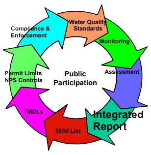
Clean Water Act 303(d) List & 305(b) Report
New Jersey’s surface waters provide much of the water used for drinking water supplies, recreation, fishing, boating, swimming, commercial fisheries including shellfish, and tourism, all of which support our State’s’ ecology, economy, and quality of life for our residents.
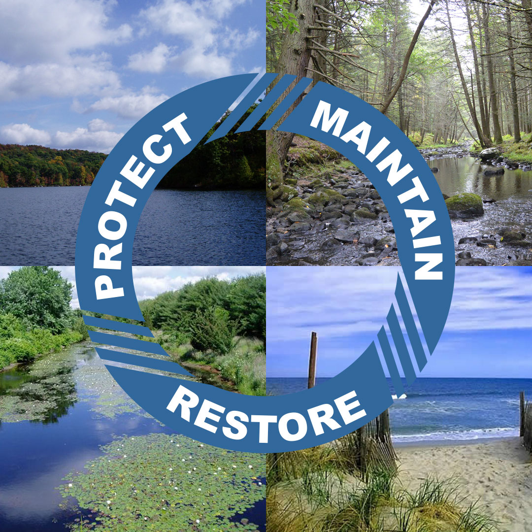
The New Jersey Integrated Water Quality Assessment Report (Integrated Report) is a compilation of information about the quality of New Jersey’s surface waters. The New Jersey Department of Environmental Protection (DEP) prepares the Integrated Report as a biennial assessment of statewide water quality that identifies and prioritizes waters for protection, restoration, and additional monitoring or research. The Integrated Report thus serves as an effective tool for enhancing, maintaining, and restoring water quality in all surface waters of the State to support their use for aquatic life, recreation, water supply, fish consumption, and shellfish harvest for consumption.
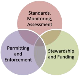
The primary purpose of the water quality assessment program is to determine the health of New Jersey’s water resources so the appropriate steps can be taken to restore, maintain and protect our water resources and their designated uses. Water quality standards, monitoring, and assessment provide the scientific foundation for the integrated assessment that supports protection of New Jersey’s water resources and implementation of the federal Clean Water Act, the New Jersey Water Quality Planning Act, and the New Jersey Water Pollution Control Act.
The DEP initiates a new water quality assessment cycle every two years. All existing and readily available data is evaluated to ensure that it meets established data quality requirements. The Integrated Water Quality Assessment Methods (Methods Document) describes the guidelines, protocols, and procedures how the data is used to determine water quality conditions.
The Methods Document provides an objective and scientifically sound assessment methodology, including:
-
-
- An explanation of DEP’s SWQS criteria and policies;
- A description of the data and the quality assurance process to determine the use of any existing and readily available data;
- A description of the methods used to analyze water quality and biological data to determine designated uses support; and
- A description of the guidance and policy for the Integrated Report.
-
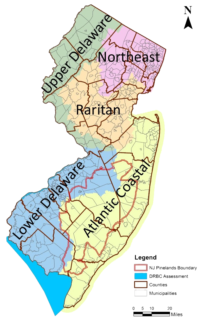
Assessment units (AUs) represent the scale at which waters of the State are grouped for assessment purposes. New Jersey waters are grouped into 958 AUs, which are delineated based on the U.S. Geological Survey (USGS) 14-digit Hydrologic Unit Code (HUC) boundaries except for waters of the Barnegat Bay Estuary and the Delaware River, and are grouped within five water regions.
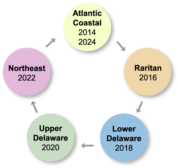
A different water region is selected each assessment cycle, on a rotating basis. Since 2014, New Jersey has employed a rotating regional approach to integrated water quality assessments. Under this approach, the Department completes a comprehensive, detailed analysis of water quality in one of New Jersey’s five water regions, Atlantic Coastal, Raritan, Lower Delaware, Upper Delaware, and Northeast each assessment cycle.
This rotating regional approach produces a comprehensive assessment of the entire State every ten years and supports development of measures to restore, maintain, and enhance water quality tailored to the unique circumstances of each region.
New Jersey uses a conservative assessment method that ensures accurate and confident decisions in identifying water quality issues and health. An impairment for a designated use may be tied to one parameter exceeding criteria at one of many monitoring sites. For more information, please see the assessment methods document below.
New Jersey is the fifth smallest, but most densely populated state in the Nation. NJ is also one of the most geologically and hydrogeologically diverse states. The state has a variety of surface waterbody types that range from intermittent streams to large river systems (a significant number of which are tidally influenced); acres of lakes, ponds, and reservoirs; and miles of estuarine and coastal (ocean) waters. Wetlands are found near most surface waterbodies, both freshwater and saltwater.
New Jersey’s surface water systems are located in a wide variety of geologic settings, from the past glaciated regions of northern New Jersey to the coastal plain of southern New Jersey, and include ecologically unique and/or protected areas such as the Pinelands and the Highlands regions.
| RESOURCES | EXTENT |
|---|---|
| State Population (2019) 1 | 8,882,190 |
| State Total Area (square miles) | 8,772 |
| State Total Land Area (square miles) | 7,254 |
| Rivers and Streams: Miles of Nontidal Rivers and Streams Miles of Tidal Rivers and Streams Miles of Rivers and Streams (total) Border Miles Shared Rivers |
– 13,695 5,730 19,425 197 |
| Lakes, Ponds and Reservoirs: Total Acres of Lakes and Ponds and Reservoirs Number of Reservoirs Acres of Reservoirs |
– 47,620 43 14,970 |
| Estuaries and Ocean: Square Miles of Estuaries Miles of Ocean Coast (linear miles) Square Miles of Ocean (jurisdictional waters) |
– 650 127 470 |
| Wetlands: Acres of Freshwater Wetlands Acres of Tidal Wetlands Total Acres of Wetlands |
– 739,160 209,269 948,429 |
1) 2019 US Census estimate
Spatial extents shown in this table are calculated based on 1:24,000 scale from the Department’s GIS coverages for the applicable water resource including the National Hydrography Dataset (NHD), surface water quality classification, lakes, coastal waters, and wetlands (2002).
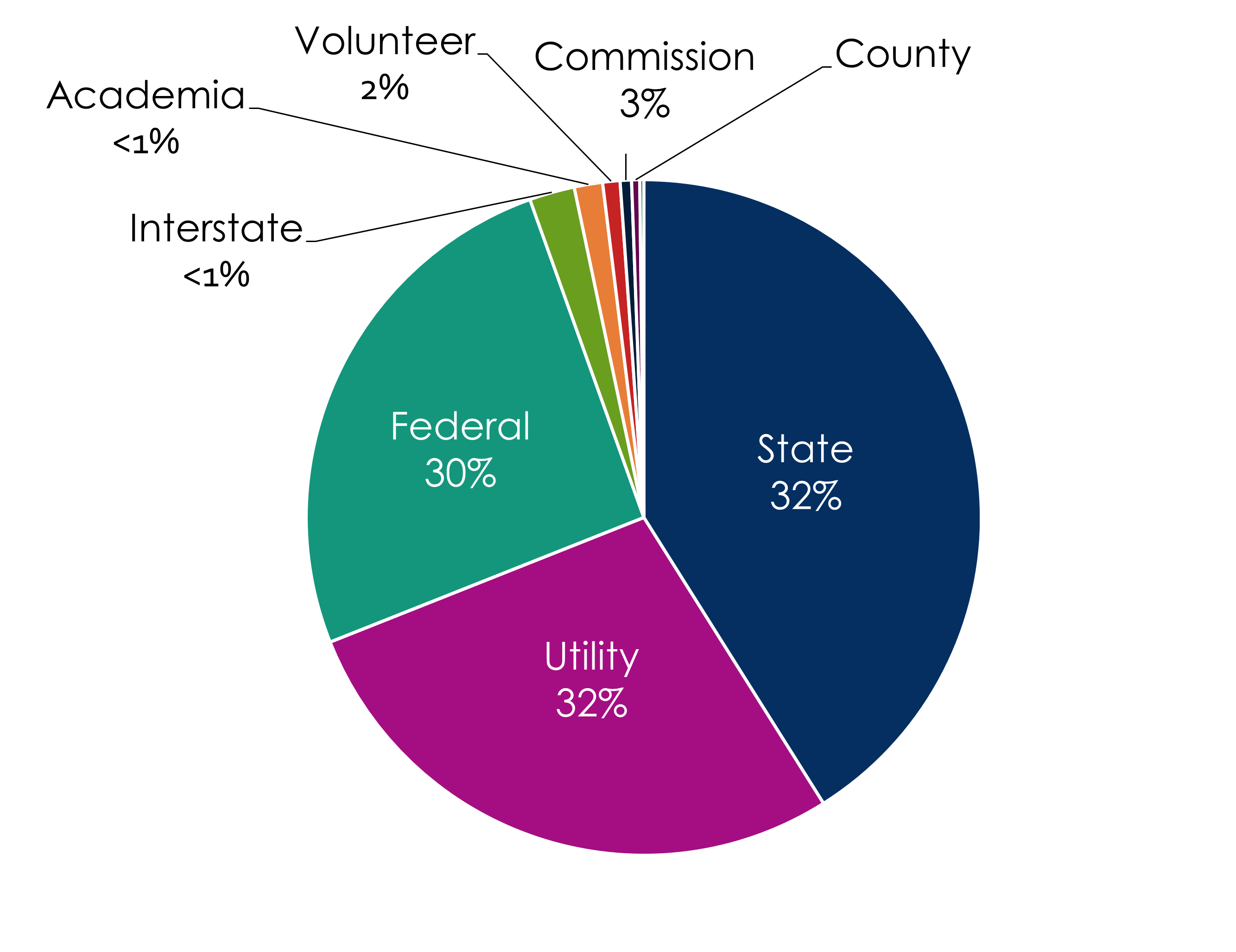
The DEP employs an integrated approach to assessing water quality by compiling a vast amount of water monitoring data and related information collected by numerous sources throughout the state.
While the principal contributor of water quality data used for assessment purposes is generated by the DEP, numerous monitoring organizations and other partners also collect relevant data. These include federal and county government agencies, regional commissions (e.g., Pinelands Commission) watershed associations and other voluntary citizen monitoring, and utility organizations.
All monitoring data must have an approved Quality Assurance Project Plan (QAPP) that includes acceptable sampling procedures. Information for developing QAPPs, sampling protocols and other resources for water monitoring may be found on the DEP’s website.
The Department’s most recent data solicitation covering the monitoring data in the Integrated Report and 303(d) List from the 2020 through 2026 assessment cycles can be found here as public noticed in New Jersey Register Volume 50, Issue 13, July 2, 2018 (50 N.J.R. 1507(b)).
DEP’s strategic goal outlined in the “New Jersey Water Monitoring & Assessment Strategy (2022-2032)” to develop a comprehensive monitoring program for all waters of the state has resulted in a drastic increase in the number of monitoring stations and samples collected over the last decade. In collaboration with other water monitoring stakeholders and agencies, the number of AUs with data has risen significantly and has resulted in a comprehensive understanding of water quality conditions.
Since 2006 which is the first Integrated Report that AUs were based on HUC14 sub-watersheds, the number of unassessed designated uses caused by insufficient data declined from 38% to only 18% AUs with insufficient data, the number of AUs with at least one designated use assessed rose to 97% statewide, and the number of AUs where all of the designated uses are assessed rose over 35% to 62% statewide1.
1. This includes all of the designated uses except for fish consumption.
Databases Used in the Integrated Report
| Data Web Site | Description |
|---|---|
| The Water Quality Portal (WQP) | Primary water quality data portal. All data collected by the DEP and other monitoring organizations is accessed through the WQP. Does not include continuous data. |
| DEP Continuous Data Monitoring | Access continuous data collected by the DEP |
| USGS Continuous Data Monitoring | Access continuous data collected by the USGS |
| Recreational Beach Conditions | Find current beach status, water quality sample results, reports of beach advisories and beach closings, and information on other events that affect beaches. |
| Shellfish Harvesting Conditions | Find current shellfish harvesting classification including data from monitoring stations. |
| EcoSHEDS | Find current continuous stream temperature data collected by NJ stakeholders. |
Water quality assessments are categorized into three statuses, Fully Supporting, Not Supporting, or Insufficient Data for assessment. Based on EPA guidance, these statuses are placed in sublists for the Integrated Report as described in the table below. In addition, subparts are added to Sublist 4 and Sublist 5 to help clarify the response strategy for impairments.
| Sublists | Description |
|---|---|
| Sublist 1 / Sublist 2 | An assessment unit is Fully Supporting designated uses and no uses are threatened. |
| Sublist 3 | Insufficient Data and information to determine if the designated use is fully supported or not supported. |
| Sublist 4 | One or more designated uses are Not Supported or are threatened but TMDL development is not required because of one of the following reasons: |
| Sublist 4A | A TMDL has been completed for the parameter causing designated use non-support. |
| Sublist 4B | Other enforceable pollutant control measures are reasonably expected to result in fully supporting the designated use in the near future. |
| Sublist 4C | Non-support of the designated use is caused by something other than a pollutant. |
| Sublist 5 (303(d)) | One or more designated uses are Not Supported or are threatened by a pollutant(s), that requires development of a TMDL. |
| Sublist 5A | Arsenic does not attain standards, but concentrations are below those demonstrated to be from naturally occurring conditions. |
| Sublist 5L | Designated use impairment is caused by a “legacy pollutant” that is no longer actively manufactured or discharged by a point source. |
| Sublist 5R | Water quality impairment is not effectively addressed by a TMDL, such as nonpoint source pollution that will be controlled under an approved watershed restoration plan or 319(h) Watershed Based Plan. |
Sublist 5 – Pollutants placed on the 303(d) List, also identify their priority ranking for TMDL development (High, Medium, Low). TMDLs for pollutants identified on Sublists 5A, 5L and 5R are assigned a low priority for TMDL development since alternative restoration measures are being pursued.
Sublist 5R – Development of a watershed restoration plan can be an effective alternative to a formal TMDL to characterize pollutant sources, the reductions needed to attain standards, and the means to achieve the reductions. The DEP is pursuing this approach where stormwater and nonpoint sources of pollution are considered to be the predominant source of water quality impairment.
The Surface Water Quality Standards (SWQS), N.J.A.C. 7:9B, establish the designated uses and antidegradation categories of the State’s surface waters, classify surface waters based on those uses (i.e., stream classifications), and specify the water quality criteria and other policies and provisions necessary to attain those designated uses. Designated uses include water supply for drinking, agriculture and industrial uses, fish consumption, shellfish resources, propagation of fish and wildlife, and recreation. In addition, the SWQS specify general, technical, and interstate policies, and policies pertaining to the establishment of water quality-based effluent limitations.
The current SWQS rules (N.J.A.C. 7:9B) were readopted in 2016 and amended in 2020. The SWQS are used to develop regulatory requirements for other Department programs that will serve to protect the existing and designated uses of the State’s surface waters. These programs include the New Jersey Pollutant Discharge Elimination System (NJPDES) program, Site Remediation Program, and various programs implemented by the Division of Land Use Regulation.
The SWQS also form the basis for the Integrated Report. Waters that exceed SWQS require the development of total maximum daily loads (TMDLs) or other alternative approaches to address the impairment. The Department has developed a Nutrient Criteria Enhancement Plan (NCEP) to explain the Department’s approach to developing and enhancing the existing SWQS nutrient criteria and policies to protect designated uses of all New Jersey’s surface waters, including saline waters (estuarine and marine).

The antidegradation policies instituted by SWQS are divided into three tiers: Outstanding National Resource Waters (ONRW), Category 1 Waters (C1), and Category 2 Waters (C2). ONRW carries the highest protection and applies to FW1 (nondegradation) and PL (Pinelands) waters. ONRW waters must be maintained in their natural state. The only changes to water quality allowed are those that restore natural water quality. C1 waters are recognized due to their exceptional ecological, recreational, water supply, or fisheries significance. C2 waters protect designated uses and require improvements to waterbodies that do not meet standards. In all three tiers, designated uses and water quality must be maintained and protected, and impairments must be restored to standards.