Other Technical Maps and Reports
The maps and reports provided below are technical in nature but have not been peer-reviewed. The information presented in these documents pertains to, but is not limited to, earthquakes and New Jersey topography.
Earthquake Loss Estimation Studies: Geologic Component
Damaging earthquakes in New Jersey are rare, but they have occurred and undoubtedly will again. Although predicting the time, place, and magnitude of earthquakes is not possible, their potential to do damage can be. Structural damage caused by an earthquake depends on how much the ground shakes. The amount of ground-shaking, in turn, depends on how soft and how deep the soil is, and on the type of bedrock lying beneath it. Also important is whether the soil type will lose strength, liquefy or slide downhill when shaken.
Computer software (HAZUS, for Hazards U.S.) developed under the direction of the Federal Emergency Management Agency (FEMA) was developed to simulate ground-shaking, building damage, and estimate economic loss, for potential earthquakes. The simulations take into account the magnitude and location of the earthquake, the physical properties of the soil and bedrock, and the type of building construction in the study area. Results of these simulations are used to guide the strengthening of structures built on vulnerable soils and to plan emergency response.
The Survey, with partial funding from the N. J. State Police Office of Emergency Management, maps seismic soil properties, including shaking behavior, liquefaction susceptibility, and tendency to landslide. This is completed by county at 1:24,000 scale.
Shaking behavior is mapped according to the methods developed by the National Earthquake Hazards Reduction Program. Liquefaction and landslide susceptibility are mapped according to the classifications used in the HAZUS model. For each county, HAZUS simulations use geologic data to provide damage and loss estimates for selected earthquake scenarios. The reports below provide details on these soil properties and economic loss estimates. The data on building stock used in these simulations are supplied with the HAZUS software and are from both federal and commercial sources. The building data have not been checked or verified by the N. J. Geological Survey.
The GIS ESRI™ shapefiles of Soil, Liquefaction and Landslide Susceptibility in New Jersey are available at DGS15-2.

Earthquakes in New Jersey, 1973 (Revised 1977)
Sample pages from Earthquakes in New Jersey, 1973 (Revised 1977).
This document includes a brief discussion of seismology, a listing of seismograph stations in and near New Jersey, an account of minor seismic activity related to the Triassic Border Fault and other areas in the state, and a listing of all the major and minor earthquakes large enough to be felt in New Jersey, and a few (too weak to be felt) detected by very sensitive seismographs. Authored by Daniel R. Dombroski, Jr. Published in 1970, revised in 1977.
An updated list and location map of earthquake occurrences in New Jersey is can be found in DGS04-1.
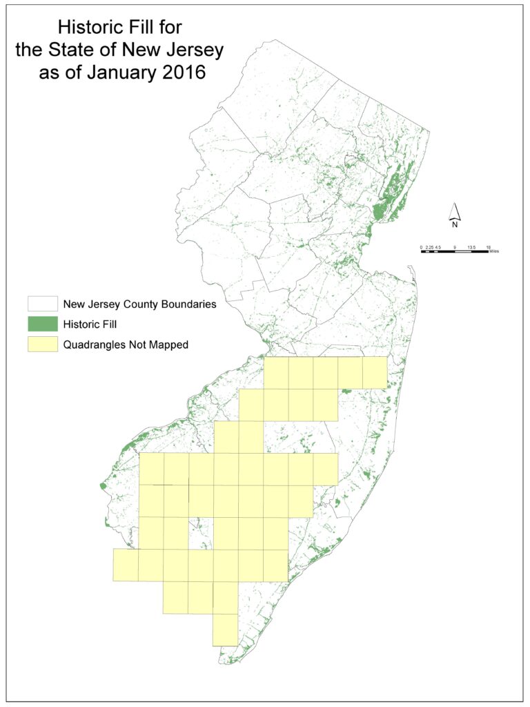
Brownfield Historic Fill
The “Brownfield and Contaminated Site Remediation Act” (N.J.S.A. 58:10B-1 et seq.) requires the Department to map regions where large areas of historic fill exist and to make this information available to the public. The Survey prepared maps showing areas of historic fill covering more than five acres. For the purposes of these maps, historic fill is non-indigenous material placed to raise the topographic elevation of a location. No representation is made as to the composition or contamination of the fill. These maps are not intended to be used at a parcel-scale. Any local evaluation of historic fill must be conducted by appropriate governmental agencies.
TuckaHoe NJ Marmora NJ
Runnemede NJ Delaware City DEL-NJ
Clementon NJ Salem NJ
Medford Lakes NJ Alloway NJ
Indian Mills NJ Elmer NJ
Chatsworth NJ Newfield NJ
Woomansie NJ Buena NJ
Brookville NJ Newtonville NJ
Forked River NJ Egg Harbor City NJ
Barnegat Light NJ Green Bank NJ
Wilmington South DEL-NJ New Gretna NJ
Penns Grove NJ-DEL Tuckerton NJ
Woodstown NJ Taylor Bridge DEL-NJ
Pitman East NJ Canton NJ-DEL
Pitman West NJ Millville NJ
Shiloh NJ Five Points
Williamstown NJ Bridgeton NJ
Hammonton NJ Dorothy NJ
Atsion NJ Mays Landing NJ
Jenkins NJ Pleasantville NJ
Oswego Lake NJ Bombay Hook DEL-NJ
Brigantine NJ Ben Davis Point NJ–DEL
Oceanville NJ Cedarville NJ
West Creek NJ Dividing Creek NJ
Ship Bottom NJ Port Elizabeth NJ
Fortescue NJ Port Norris NJ
Heislerville NJ Woodbine NJ
Sea Isle City NJ Rio Grande NJ