 OFFICIAL SITE OF THE STATE OF NEW JERSEY
DGS02-6 A Recharge-Based Nitrate-Dilution Model for New Jersey V6.1
Abstract
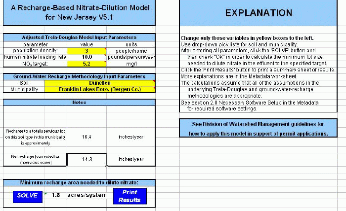
Digital Geodata Series DGS02-6 consists of an Excel workbook that applies a recharge-based nitrate-dilution model for New Jersey. This methodology enables the user to estimate the average area required per disposal system to generate enough ground-water recharge to dilute the nitrate in that system’s effluent to acceptable levels. The recharge-based nitrate-dilution model described here is a synthesis of two independent methods: a mass-dilution model and the New Jersey Geological Survey’s (NJGS) ground-water-recharge method. The end result is an estimate in acres per disposal system.
The mass-dilution model is modified from Trela and Douglas (1978). The Trela-Douglas nitrate dilution model has been used in New Jersey for more than 20 years to estimate nitrate concentrations in ground water from on-site subsurface wastewater disposal systems. As originally published, the model required data on household occupation rate, per capita water use, lot size per home, recharge rate, and the nitrate concentration in the effluent. As implemented here, this method requires only the household occupation rate (number of people per house) and the per capita nitrate loading rate (pounds per person per year). It also has been modified to account for the reduction in recharge due to impervious cover on the developed lot.
The NJGS’ ground-water-recharge method (Charles and others, 1993) is a water-budget approach that estimates average annual ground-water recharge based on land use, soil type and a municipality-based climate factor. It is applicable only to New Jersey. As implemented here the user needs only to input the soil type and the municipality.
The two underlying models are combined to produce a recharge-based nitrate-dilution model. This requires an additional parameter, a nitrate target. The target is the concentration that nitrate in the ground-water should not exceed after dilution is taken into account. The model’s result is an estimate of required acres per system which will provide enough recharge to dilute the nitrate emitted by an on-site subsurface wastewater disposal system to meet the specified water-quality target.
This method addresses just one factor in determining how dense a development a specified area can sustain without undesirable effects on the environment. Other factors, such as other non-point source contaminant loading, infrastructure capacity, open-space requirements, and ecological impacts must be addressed in determining the actual carrying capacity of a specific tract of land.
The Excel workbook is titled ‘nj_no3_dilution_v6.1.xls.’ In order to run the methodology Excel must have access to the file SOLVER.XLA. This is an add-in file to EXCEL 97 that must be activated. Details are in the metadata section of this report. Version 6.0 added new climate factors based on a smoother interpolation of data from meteorological sites to municipalities, includes new SSURGO soils, and updates the workbook to Excel 2003. Version 6.1 makes a minor modification to an internal flag that was returning misleading values for some soils.
The metadata section in the file describes these changes, as well as previous versions.
References
Charles, E.G., Behroozi, Cyrus, Schooley, Jack and Hoffman, J.L., 1993, A method for evaluating ground-water-recharge areas in New Jersey: N.J. Geological Survey Report GSR-32, Trenton, 95p.
Trela, J.J. and Douglas, L.A., 1978, Soils, septic systems and carrying capacity in the New Jersey Pine Barrens: paper presented at the First Annual Pine Barrens Research Conference, Atlantic City, May 22, 1978, 34p.
 Sample image.