DGS09-1 Reservoir Storage and Related Diversions in the Passaic and Hackensack River Basins, 1898 to 2015
Abstract
This New Jersey Geological Survey (NJGS) Digital Geodata Series (DGS) publication is a Microsoft Excel™ 2016 workbook that contains end-of-month reservoir storage and monthly diversion volumes for selected potable-supply water purveyors located in the Passaic and Hackensack River Basins in northeastern New Jersey. The water purveyors in this publication are the larger surface-water diverters in the region that transfer water over large distances and supply potable water to the major metropolitan populations of northeastern New Jersey. These purveyors include: United Water (United Water New Jersey and United Water New York, and formerly known as the Hackensack Water Company and the Spring Valley Water Company), Jersey City, Newark, North Jersey District Water Supply Commission, New Jersey American Water Company, Passaic Valley Water Commission, as well as several smaller associated purveyors. Records go back to 1898, which predates most but not all of the water-supply projects in the region.
The data contained in this publication were initially measured and recorded by the water purveyor operating the storage or diversion facility. The United States Geological Survey (USGS) compiled and published the data in one or more formal reports. The USGS data were originally published in two Water Supply Paper compilation reports and the annual New Jersey Water Resources Data Reports. Most of the reports are available on-line from USGS’s Publications Warehouse. None are available in the digital spreadsheet format presented here. The data contained in this publication were transcribed from those USGS reports.
The reports available from the USGS web page are image files of the original paper reports and not readily converted to spreadsheet formats. NJGS is publishing these data in a Microsoft Excel™ spreadsheet since it allows the data to be better utilized in any number of ways. For example, the data can be cut and paste for use in hydrologic models (safe yield modeling), water resource management and planning investigations, or water allocation permitting.
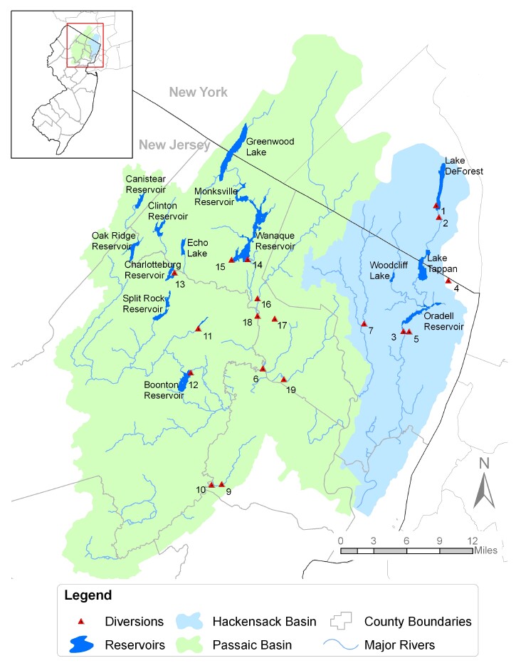
This Microsoft Excel™ 2016 workbook contains nine worksheets. Three worksheets contain the storage, diversion, and stage-storage datasets. Each of those has as a corresponding worksheet that lets the user select and plot the data. One worksheet contains the User’s Guide, one contains a map of the region, and one is used for Excel lookup and reference information.
The layout of the diversion and storage tables is based on a generalized layout of the USGS reports. Every effort was made to prevent data transcription errors, but data accuracy can not be guaranteed. Foot notes and comments regarding specific data entries that were included with the USGS publications are not transcribed here. Most of the foot notes and comments refer to estimated data or end-of-month date discrepancies. The user is strongly encouraged to refer to the original reports for specifics that might be significant to their particular needs.
The NJGS is publishing this data with permission of the USGS for use by the Department of Environmental Protection and the public. However, any use of this data is the responsibility of the individual or group utilizing the information and not that of NJGS.
In March 2011, diversion data for one site were corrected for a two-year period and an Excel formula reference was fixed for the diversion summary chart.
In February 2013, this report was updated with Water Year (WY) 2007 through WY 2011 (September 2011) information.
In May 2017, this report was updated with Water Year (WY) 2011 through WY 2015 (September 2016) information.
Map showing locations of major potable supply reservoirs and diversions in the Passaic and Hackensack River basins.