
GIS Resources

General information on the water quality assessment program and the Integrated Report. (Homepage)

Comprehensive water quality assessment report that determines the health of New Jersey’s water resources.

Access databases where publicly-available water quality data is stored. Description of DEP and non-DEP monitoring programs statewide.

DEP advisories on current and historical water quality conditions. Relevant water quality reports and special studies.

Description and access DEP programs focused on protecting, preserving, and restoring water quality throughout the state.
DEP provides water quality data and conditions in a variety of approaches. One of the most important tools used by DEP includes geographic information system (GIS) data, maps, and applications.
The principle GIS tool used by DEP is NJ-GeoWeb. This application provides users access to DEP GIS data on the internet. Users can view, query and analyze DEP’s GIS data with related environmental information. One major enhancement is the ability to upload Shapefiles from a local drive, and data from other sources for viewing within the application.
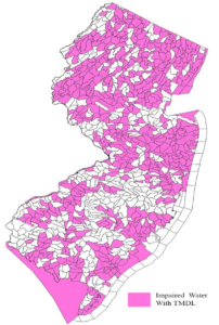
The Integrated Report includes interactive GIS maps that provide the water quality assessment results for all of the designated uses and their applicable parameters can be viewed at all monitoring stations and assessment unit level. Additionally, other tools provided by DEP include maps and applications (ie storymaps) that provide water quality related information and GIS water quality data files.
Water Quality GIS Resources
| Integrated Report Interactive Water Quality Maps |
| Important GIS Water Quality Data |
|