
Community Water Monitoring
“Community water monitoring” is the collection of scientific water quality data by concerned citizens working in partnership with professional scientists and government decision-makers. This valuable data helps determine the ecological condition of local waterbodies as well as identify the causes and sources of water quality impairment. Community water monitoring includes both “citizen science” and “volunteer monitoring” activities. Anyone can participate in community water monitoring – all you need is an interest in your watershed.
Data Collection
| Visual/Habitat | Biological/Macroinvertebrate | Bacterial | Chemical | Algal Blooms |
|
|
| Greatest variability in methods, parameters, and associated data quality and costs:
|
|


A stonefly is a pollution-intolerant macroinvertebrate.
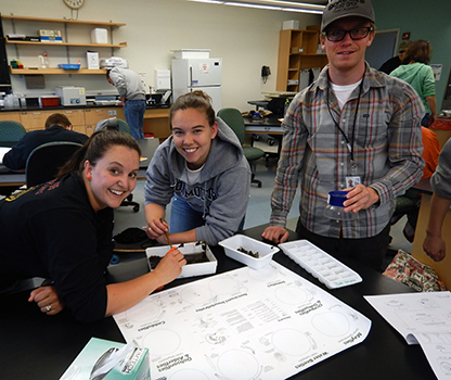
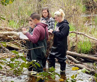
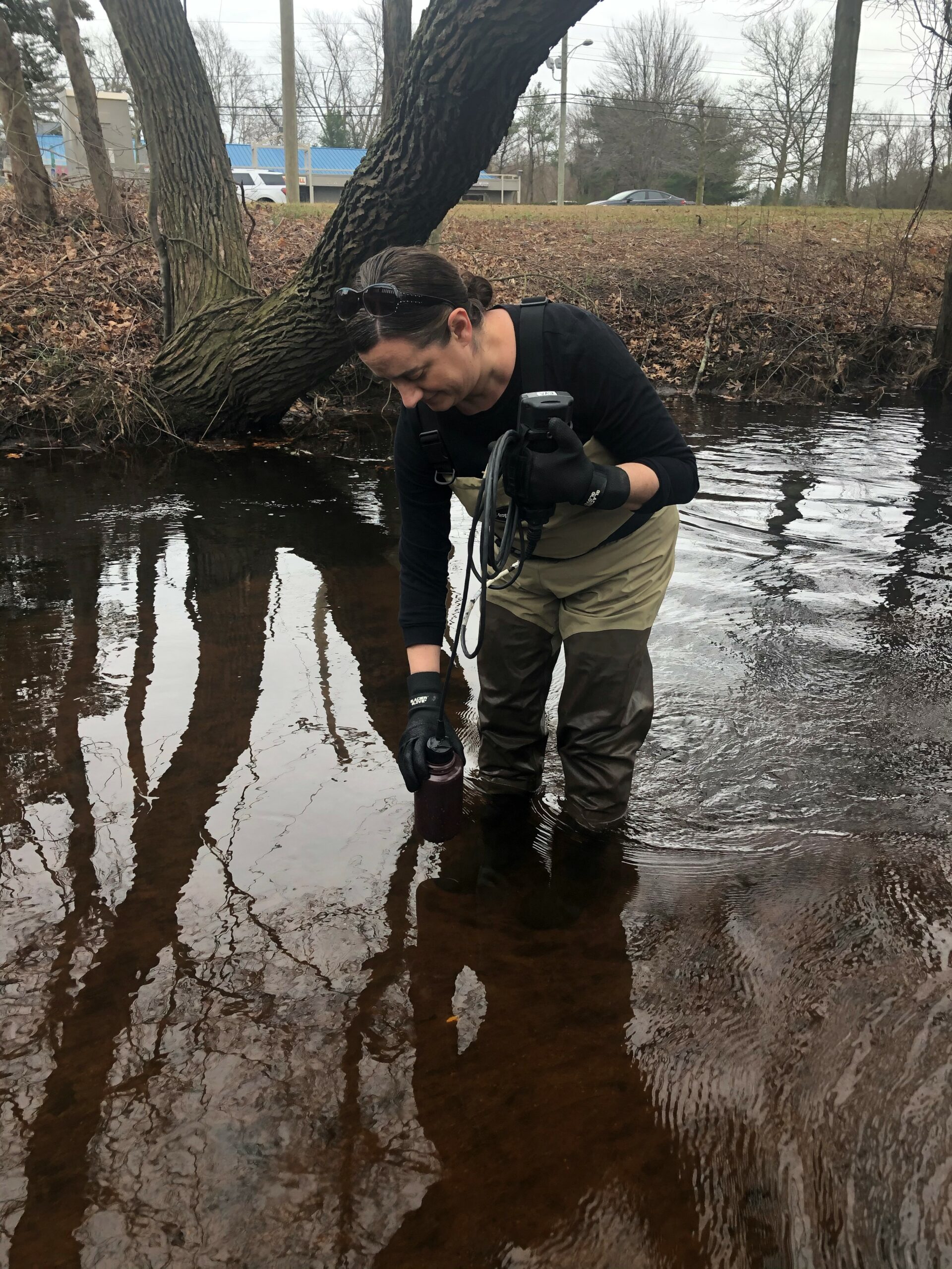
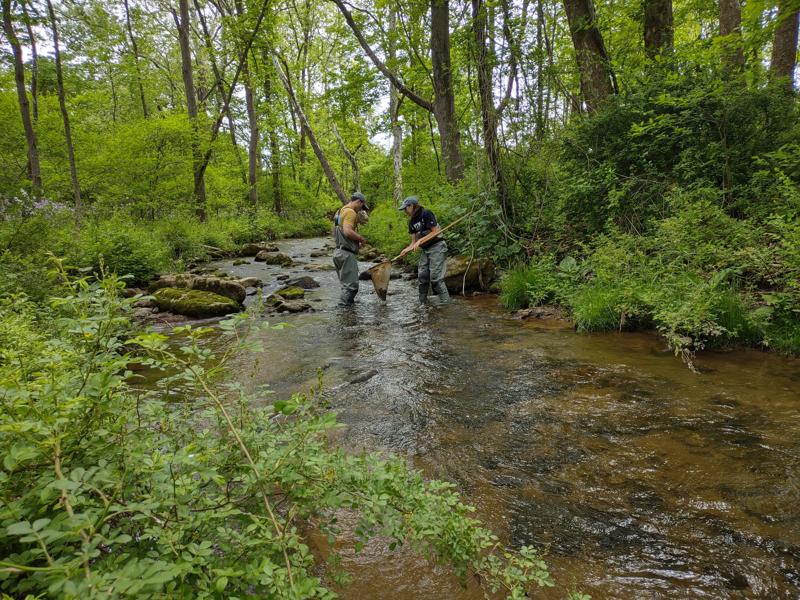
Community water monitoring data is collected in various ways depending on the project. You might wade into a stream to collect macroinvertebrates (the organisms that live on the stream bottom) or visit a lake to make observations based on what you see. Some projects require use of specific equipment, such as specialized thermometers, nets or electronic water quality meters. Other projects require only your eyes, the data form, a pen and a clip board.
One common method used by community water monitoring groups is biological assessment via the identification of macroinvertebrates. It’s a great way to get a snapshot of the overall health of a freshwater stream, since sensitivity to pollution varies by species. If many pollution-sensitive species are found, the stream is likely to be healthy, whereas if only pollution-tolerant species are found, additional tests may be needed to check for sources of stream impairment.
Some community water monitoring groups conduct chemical assessments. They use a probe, test strips, and/or reagents to measure parameters like nitrate, phosphate, chloride, specific conductance, turbidity, pH, dissolved oxygen and temperature. If a biological assessment indicates that a stream is impaired, chemical monitoring might explain the cause.
How is the data used?
The Community Water Monitoring Tiered Data Quality Framework defines the appropriate uses of the data, depending on the quality, type, and format:
- TIER 1: Community education and municipal engagement
- TIER 2: Water quality report cards, tracking down pollution sources, monitoring BMP effectiveness, and NJDEP Comprehensive Regional Assessments (plus Tier 1 uses)
- TIER 3: Regulatory assessments, including New Jersey’s Integrated Water Quality Assessment Report (plus Tier 1 & 2 uses)
- The map displays the data contributed by community water monitoring organizations for the 2018/2020 Integrated Report (list of data organizations)
Protocols for Community Water Monitoring


The NJDEP Division of Water Monitoring, Standards and Pesticide Control’s Bureau of Environmental Analysis Restoration and Standards (BEARS) has developed protocols for performing a habitat and biological (aquatic benthic macroinvertebrate) assessment of stream health. The AmeriCorps New Jersey Watershed Ambassador Program currently follows these protocols to conduct stream assessments for the Department. The protocols, which include a manual and data forms, are available under the first heading below.
These protocols may be used to collect data that can enhance your group’s ability to promote community education and participation in watershed stewardship. They may also be used to develop or refine a Quality Assurance Project Plan (QAPP) for your organization to ensure the quality and confidence level of your data. Approved QAPPs are required to be considered a Tier 3 project (see Study Design and QAPPS).


Study Designs and Quality Assurance Project Plans (QAPPs)
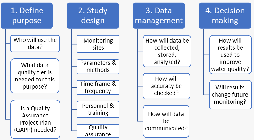
Study DesignDesigning a water monitoring study begins with identifying what question you are trying to answer. For example:
See also: |

Quality Assurance Project Plans
- How do you ensure the quality of your water monitoring program’s data?
- How do you ensure that the level of confidence in your data is commensurate with its desired use and data objectives?
A Quality Assurance Project Plan (QAPP) is a key tool to address potential uncertainties that may affect the quality of your data, such as how volunteers are trained; how samples are collected, handled and stored; or how data were analyzed and reports written. A QAPP is a document which outlines all procedures that will be followed by those conducting a monitoring project to ensure that the data they collect and analyze meet project requirements. It also serves as a record of methods, goals, and procedures that current and future volunteers will follow and that potential users of the data can consider. Links to QAPP resource materials are provided under the headings.
Resources for Community Water Monitoring
The National Water Quality Monitoring Council's Volunteer Monitoring workgroup is a national resource for learning about community-based water monitoring activities in other states.
Visit the Water Quality Portal to view the water quality data collected in New Jersey and across the United States by federal and state agencies, tribes, watershed groups, volunteer groups, and universities.

USEPA Participatory Science for Environmental Protection Website to find resources for new and established projects.
USEPA Participatory Science StoryMap to learn about community science projects taking place across the nation.
USEPA Region 2 has equipment available to loan for community water monitoring. Contact Rachael Leta-Graham at letagraham.rachael@epa.gov for more information.
Multiple New Jersey-based resources are available to support community water monitoring:
The New Jersey Watershed Watch Network, funded by NJDEP and The Watershed Institute, promotes the health and resiliency of New Jersey's Watersheds by strengthening, connecting, and mobilizing watershed organizations. It builds capacity and partnerships via workshops, trainings, sharing best practices and lessons learned as well as providing small grants across the community.
The AmeriCorps NJ Watershed Ambassadors provide free hands-on introductions to volunteer water monitoring using habitat and macroinvertebrate assessments.
The New Jersey Water Monitoring Council serve as a statewide body to promote and facilitate the coordination, collaboration and communication of scientifically sound, ambient water quality and quantity data to support effective environmental management. They hold several meetings per year that are open to members of the public.


Get Involved
There are many organizations, watershed associations, schools, and other entities that collect water quality data and information on local streams, rivers, and other waterbodies in New Jersey. The work of these groups is invaluable to understanding and improving the health of New Jersey’s watersheds. Some of their goals and objectives are to:
- Promote watershed stewardship
- Raise awareness about water quality issues
- Identify and report on current and changing water conditions
- Screen for water quality or biological impairment
- Evaluate the impacts of restoration projects on water quality
- Supplement water quality data collected by state and federal monitoring programs
How Can I Get Involved?

Visit the New Jersey Watershed Watch Network (NJ-WWN) website. NJ-WWN, a program funded by NJDEP and The Watershed Institute, provides support for community-based water monitoring programs across the state.
See the map below to locate a water monitoring group near you.
Visit our AmeriCorps New Jersey Watershed Ambassadors Program page to identify the AmeriCorps Watershed Ambassador for your Watershed Management Area (WMA) and request a hands-on introduction to Volunteer Monitoring.
Visit our Study Design and Quality Assurance Project Plan (QAPP) page for guidance on designing your own monitoring project.
Get involved with Trainings
Get involved with a Community Water Monitoring Project
New Jersey Watershed Watch Network Partners
The map below shows NJ Watershed Watch Network Partners, which includes organizations that currently have or may be interested in starting a scientific or educational monitoring program, plus organizations that provide support services for such programs. If you don’t see your organization represented, please contact Debbie Kratzer at Deborah.Kratzer@dep.nj.gov or submit your information via the link under the map on the NJ Watershed Watch Network website.

(Click the image to visit the interactive map on the NJ-WWN website.)

Stream School
Stream School is a two-day classroom and field workshop in which participants are introduced to basic stream ecology and biological monitoring and assessment techniques for streams and rivers. Attendees learn how to collect and identify the organisms (e.g., bugs) living in the water that are key indicators of stream health. Stream School is usually held twice a year – generally in the Spring and Fall.
To find out when the next session of Stream School is, visit the NJ Watershed Watch Network or contact Debbie Kratzer.
Water Quality Exchange (WQX) and Water Quality Portal (WQP)
WQX is the mechanism for community water monitoring organizations to share their data with NJDEP programs or others across New Jersey and the nation. WQP is the mechanism for anyone, including the public, to retrieve water monitoring data stored in WQX.
EPA water quality data website to view training videos and other helpful resources related to WQX and WQP. For further guidance, please contact the NJ Watershed Watch Network.
Other Trainings
Throughout the year the NJ Watershed Ambassadors host training opportunities in your local watershed. These trainings are introductions to NJDEP’s biological assessment and habitat (visual) assessment protocols. To find a training near you, follow us on Facebook.
Community Water Monitoring Projects


Descriptions of active community water monitoring projects can be found under the headings below. More detailed information about the projects can be found in this comparison table, which may help individuals identify the best water monitoring opportunity for them. The map shows the monitoring locations for all the programs mentioned on this page. In addition, NJDEP has many other opportunities for those interested in other NJ community science projects, including air quality, wildlife, and more.
- American Littoral Society
- Barnegat Bay Partnership
- Clean Ocean Action
- Great Swamp Watershed Association
- Lower Raritan Watershed Partnership
- Raritan Headwaters
- New Jersey Watershed Watch Network: Road Salt Monitoring
- Musconetcong Watershed Association
- Shark River Cleanup Coalition Citizen Science - Water Monitoring Program
- Sourland Conservancy
- SPLASH Steamboat Classroom
- The Watershed Institute
American Littoral Society
The American Littoral Society conducts quarterly water quality monitoring with the help of their Restoration Corps, a summer internship program for local youth aged 16-24. They monitor 5 sites in Cumberland County in order to assess the impact of various restoration projects on water quality. Their monitoring protocol includes:
- Using a YSI sonde to measure temperature, pH, turbidity, specific conductance, and dissolved oxygen
- Taking flow measurements and grab samples, which are lab tested for nitrogen and phosphorus levels
- Conducting biological (macroinvertebrate) assessments
Recruitment for the Restoration Corps starts in April, with trainings beginning in May and June. Volunteers of all ages are needed year-round to help with the maintenance and upkeep of ALS’s two continuous monitoring sensors, which are checked bimonthly. For more information, visit littoralociety.org or contact Zach Nickerson.
Barnegat Bay Partnership
Barnegat Bay Partnership monitors water quality to complement NJDEP’s ongoing Barnegat Bay Long Term Ambient Monitoring Program. Monitoring takes place monthly at Mill Creek in Manahawkin and Westecunk Creek in West Creek. Water quality parameters measured in the field include temperature, dissolved oxygen, salinity, and pH. In addition, samples are collected in bottles and sent to an NJDEP-certified lab for analysis of nutrients, pathogens, chlorophyll and more. Individuals interested in volunteering with the program should contact Karen Walzer, the BBP Volunteer Coordinator, at kwalzer@ocean.edu.
Clean Ocean Action

Clean Ocean Action aims to track down sources of pathogen pollution through their two “Rally for the Waterways” initiatives:
- Rally for the Two Rivers focuses on the Navesink and Shrewsbury River watersheds. COA monitors bacterial levels at in-river and upstream locations with the help of trained volunteers. Citizens can also contribute to the project at any time through COA’s Two Rivers Water Quality Reporting Form, reporting on water quality indicators such as color, odor, litter, erosion, algae and fish kills.
- Rally for Barnegat Bay (RBB) focuses on the Toms River watershed and surrounding municipalities. If monitoring detects sources of pathogen pollution, the program then connects municipalities with funding to remedy the issue. Starting in early 2022, volunteers are needed for water quality monitoring in both wet-weather and ambient conditions in the following municipalities: Beachwood, Island Heights, Ocean Gate, Pine Beach, South Toms River, and Toms River.
The Great Swamp Watershed Association (GSWA) welcomes volunteers of all ages to participate in a variety of monitoring programs, including visual and macroinvertebrate assessments, E. coli sampling, chemical and microplastic monitoring, and culvert sampling. The program monitors the streams of the Great Swamp Watershed and the main stem of the Passaic River through Little Falls.
Data is used to compile a yearly water quality report card and to assist environmental decision-making in local municipalities. Training for the different monitoring programs is provided on a regular basis. Visit the events section of GSWA’s webpage to find the next training. For more information, contact Sandra LaVigne.
Lower Raritan Watershed Partnership
The Lower Raritan Watershed Partnership (LRWP) welcomes volunteers to two water quality monitoring programs:
- LRWP’s Streamkeepers conduct annual visual and biological assessments of 33 freshwater stream sites. Visual assessment training takes place in May, and biological assessment training takes place in September. Data is used to evaluate stream health and to measure the impact of stream restoration projects and stormwater management.
- LRWP’s Pathogens Monitors conduct weekly visual and bacterial monitoring from May – October at six non-swimming public access beach sites along the Lower Raritan River. A one-day training is provided every April or May. Pathogens monitoring data is provided to the public to help community members make informed decisions regarding on-water recreation.
Monitoring training opportunities are communicated via the Lower Raritan Watershed Partnership newsletter (sign up here to be added to the LRWP communications list), and via the events page on the LRWP website.
Musconetcong Watershed Association
The Musconetcong Watershed Association (MWA) welcomes volunteers 12+ to participate in three types of water quality monitoring:
- Habitat & Macroinvertebrate Monitoring: Following training sessions in the spring and fall, volunteers conduct visual and biological assessments at sites throughout the watershed. Data is used for education, advocacy and to track the effects of restoration projects. MWA is currently developing a QAPP, which could allow future data to be included in DEP’s integrated report.
- Harmful Algal Bloom (HAB) Monitoring: Volunteers attend training in late May and monitor lakes along the Musconetcong River from June – September. Sites with high measurements of phycocyanin (the pigment associated with cyanobacteria) are reported to DEP for follow-up.
- Synoptic Temperature Collections: During the summertime, volunteers visit points of interest along the Musconetcong River to measure temperature. No training is required. Data is used to understand groundwater inputs and, in partnership with Trout Unlimited, maintain an up-to-date thermal map of the Musconetcong and its tributaries.
To get involved, sign up via the form on MWA’s website or email Christa Reeves.
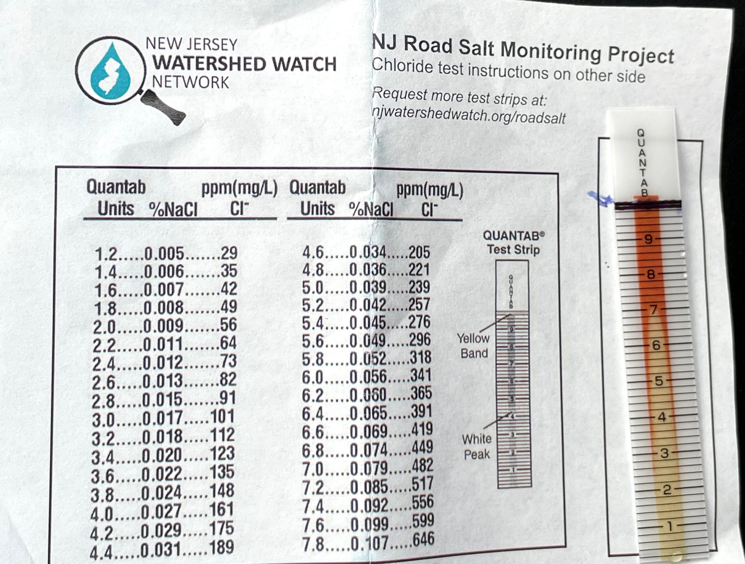
New Jersey Watershed Watch Network: Road Salt Monitoring
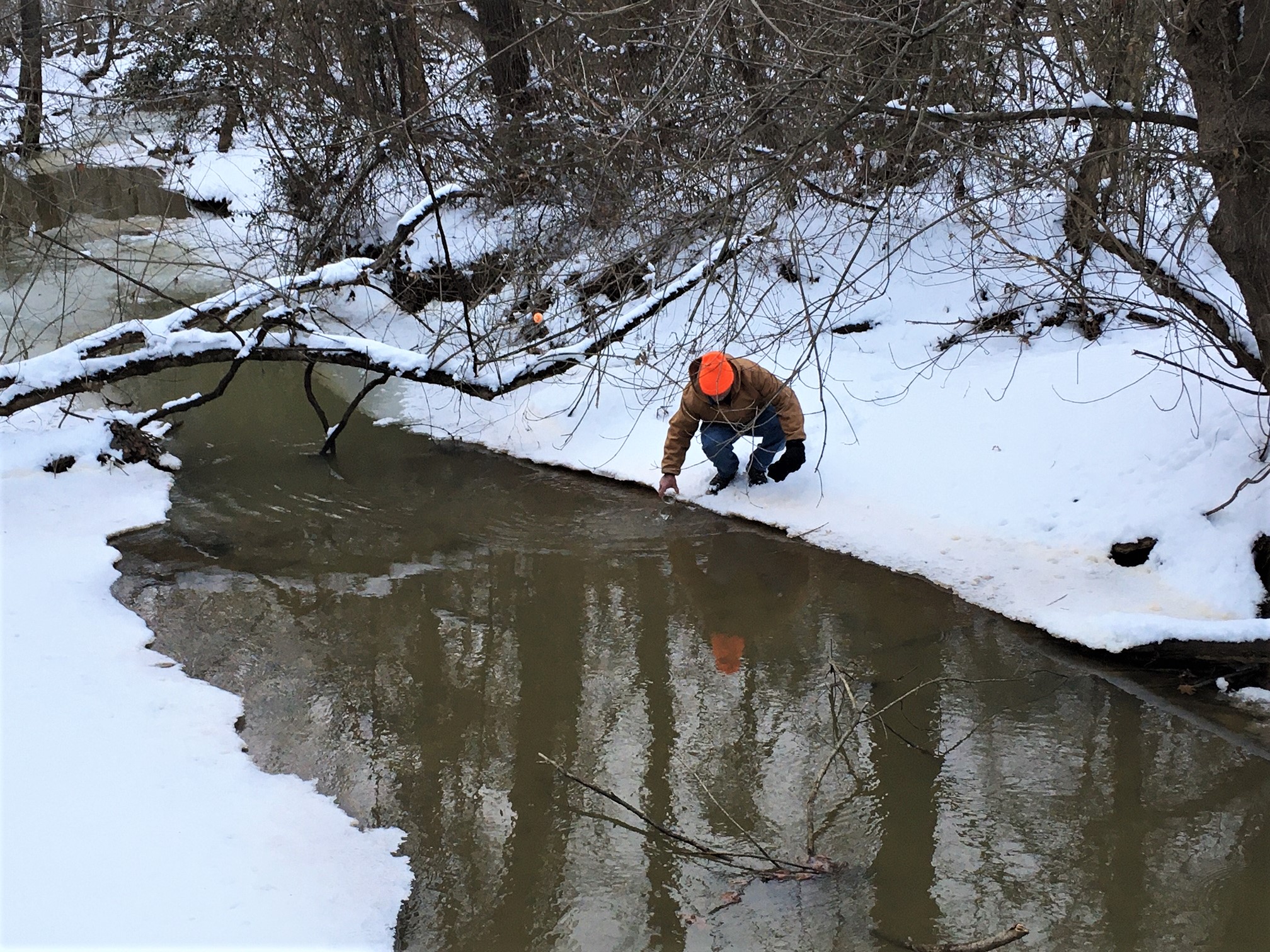
The New Jersey Watershed Watch Network (NJ-WWN), funded by NJDEP and The Watershed Institute, engages individuals and community partners across New Jersey for its annual winter road salt monitoring project. Some organizations featured on this webpage, including Clean Ocean Action, the Musconetcong Watershed Association, and SPLASH Steamboat Classroom, partner with NJ-WWN to include road salt monitoring as part of their water monitoring program.
The goal of the project is to raise awareness of the impact road salt has on our waterways. Volunteers monitor a freshwater stream or lake of their choice between December and April. They visit the site 6 times — three in dry weather and three in wet weather — to measure the chloride level using test strips. Data is uploaded to a map on NJ-WWN’s website and is used for educational purposes. NJ-WWN provides an optional training each November but interested volunteers can visit the project website anytime to request test strips and get started on their own.
Raritan Headwaters

Raritan Headwaters (RHA) conducts water quality monitoring at 70+ sites throughout the North and South Branch Raritan River watershed. The program includes biological, visual, chemical and bacterial water monitoring. While the type and frequency of monitoring varies by site, each location is assessed at least once per year.
RHA uses its water monitoring data in many ways, including to:
- Study the effectiveness of restoration projects
- Study emerging contaminants such as microplastics
- Compile reports on long-term trends in water quality
- Inform environmental decision making within the watershed
- Contribute to the NJDEP Integrated Report
RHA welcomes new volunteers 18 years or older to participate in the monitoring program. All volunteers attend an intensive training program (both online and in-person) conducted by RHA scientists in May and can expect to devote 10-12 hours to monitoring their designated sites during the June monitoring season. Visit the Raritan Headwaters website for more information and to get involved.
Shark River Cleanup Coalition Citizen Science - Water Monitoring Program

The Shark River Citizen Science - Water Monitoring Program is an all-volunteer led effort established in 2021 with support from the Shark River Cleanup Coalition. After attending initial training sessions by Rutgers and Environmental Protection Agency staff, equipment loan from EPA, and partnering with NJDEP to develop a Quality Assurance Protection Plan (QAPP), the group began monthly bacterial monitoring in September 2021.
Volunteers collect samples at eight strategically selected sites located at the base of outfall pipes along the river. The samples are then analyzed for the presence of enterococcus bacteria at a volunteer run lab in Wall Township, NJ. If analysis indicates fecal contamination, the group will consult NJDEP to verify the results, and then collaborate with government officials and stakeholders to identify the cause and correct the issue.
The group hopes to expand the scope and frequency of its testing in the future. To learn more about the Shark River Citizen Science - Water Monitoring Program and get involved, please follow their Instagram @sharkrivercitizenscience or email sharkrivercitizenscience@gmail.com.
Sourland Conservancy

The Sourland Conservancy trains volunteers aged 8+ to conduct visual and biological stream assessments in the Sourland Mountain Region, which includes Somerset County, Hunterdon County and Mercer County. The purpose of the program is to collect baseline data on Sourland streams and to determine whether land use affects water quality. Training takes place annually in May. Visit the project website to learn more and contact Stewards@Sourland.org to get involved.
SPLASH Steamboat Classroom

The SPLASH Delaware River Floating Classroom Citizen Science program is based in Lambertville, NJ, next to the beautiful Lower Delaware Wild and Scenic River. SPLASH is seeking volunteers to help collect water quality data along the main stem of the Delaware River, Alexauken Creek, and Swan Creek. Kits provided by the Watershed Institute are used to measure dissolved oxygen, pH, Nitrate, Phosphate, and turbidity in sample water.
Training is offered through the Watershed Institute with assistance from SPLASH volunteers. The time commitment is 1-2 hours of field work on the 3rd weekend of each month. For more information and to get involved, contact Allison Brown, PhD.
The Watershed Institute

The Watershed Institute’s StreamWatch program trains volunteers to conduct chemical, biological and bacterial water monitoring in the Stony Brook-Millstone Watershed. Data is submitted to the EPA’s Water Quality Exchange and used to generate quarterly water report cards. The program offers training year-round to volunteers aged 14 & older and requires a commitment of at least one year. Visit their website to sign up.