Watershed Improvement Plan
*Recommendations for additional water quality improvement projects may be sent to stormwatermanager@dep.nj.gov. Please provide all documentation supporting their effectiveness with the submission for consideration.
**NJDEP is funding a new technical assistance program with Rutgers Cooperative Extension (RCE) to assist municipalities with many of the requirements in the recently renewed Tier A permit. This program can assist municipalities with:
- Aiding in the development of the Watershed Improvement Plan,
- Helping municipalities better position themselves for stormwater funding opportunities,
- Aiding in the evaluation of long-term stormwater program improvements and solutions, such as stormwater utilities,
- Supporting MS4 and CSO Long-Term Control Plan compliance.
For more information on the RCE Water Resources Program and how it can assist your municipality with permit compliance, click here.
A Watershed Improvement Plan (WIP) is a plan required through the MS4 permits that each permittee will develop during the current five–year permit cycle and will ultimately result in water quality improvements and reduced flooding across New Jersey. The plan will be organized in three phases. Phase 1 is to complete a stormwater inventory by mapping required features. Phase 2 will evaluate the information found in the first phase to determine what potential improvement projects may be implemented to address water quality and quantity concerns. In the final phase, permittees will identify which of the potential quality and quantity improvement projects they are choosing to implement, and on what schedule.
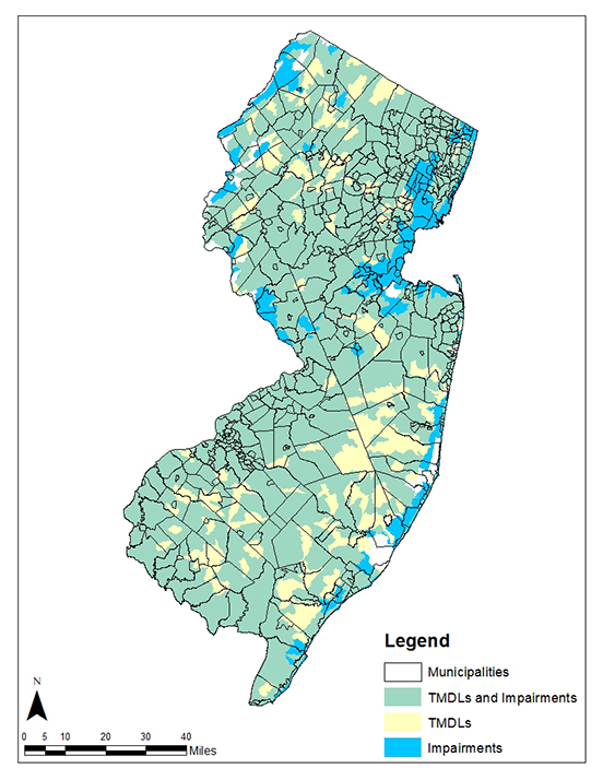
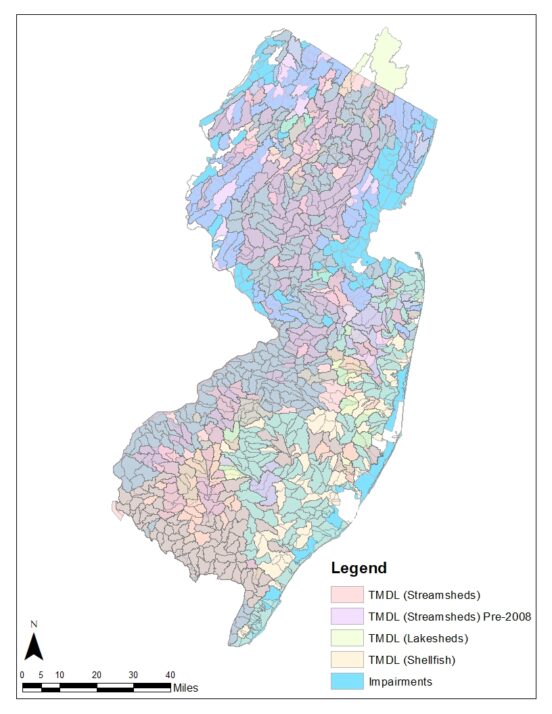
The purpose of the WIP is to identify opportunities to improve water quality, reduce MS4 contribution of pollutants to waterbodies with impairments and Total Maximum Daily Loads (TMDLs), and to address stormwater flooding to protect human health and safety, and the environment. There are many water quality impairments and resulting TMDLs that affect subwatersheds in every municipality across New Jersey (Figure 1). There are 958 subwatersheds in New Jersey (Figure 2). These subwatersheds can also be described as HUC14s and are identified by their 14-digit Hydrologic Unit Codes. Each subwatershed may have multiple TMDLs and impairments for various parameters, such as Fecal Coliform, Total Phosphorous (TP), Total Suspended Solids (TSS), Dissolved Oxygen (DO), E. coli, Nitrogen, pH, Total Dissolved Solids (TDS), Temperature, Turbidity, Polychlorinated Biphenyls (PCBs), Volatile Organic Compounds (VOCs), and metals. Some of these impairments affect fish and aquatic biota, the intakes that supply our drinking water, and the rivers and coastal waters where many of us swim. At least a portion of every town in the state has a TMDL, an impairment, or the vast majority have both. Some of these waters have no other discharges into them other than stormwater runoff.
The MS4 permits require that stormwater permittees develop or take part in the development of a regional WIP to identify water quality and quantity problems affecting their subwatersheds and determine what improvements can be made to reduce their contribution. The Department recognizes that some sources of pollution and flooding are beyond a permittee’s jurisdiction, such as farmland, or county/state/federal properties, but this exercise will help identify those sources.
The MS4 Unit is finalizing guidance materials to assist permittees in completing WIP requirements. Please check back for future updates and contact us at stormwatermanager@dep.nj.gov with any questions.

Figure 1. New Jersey’s water quality impairments from the 2020 Integrated Water Quality Monitoring and Assessment Report, and the Department’s 2018 and 2021 TMDL data by municipality. Areas with water quality impairments for which TMDLs have been developed are represented in yellow. Areas with water quality impairments for which no TMDLs have been developed yet are represented in blue. Green represents areas where both a TMDL and an impairment are present.

Figure 2. New Jersey’s water quality impairments from the 2020 Integrated Water Quality Monitoring and Assessment Report, and the Department’s 2018 and 2021 TMDL data by HUC14. White areas represent subwatersheds with no TMDL or water quality impairment. Each subwatershed may have multiple TMDLs and impairments for various parameters, so the layers are transparent to show any overlaps.