Geophysics and Subsurface Investigations
Various geophysical methods are used to investigate the subsurface geological environment for siting ground-water supply wells, studying the occurrence of ground-water contamination, assessing geologic hazards, providing field-based quality control and assurance of consultant geophysical surveys, and for archaeologic investigations. The following electronic glossary elucidates the different geophysical methods.
Magnetic Method
The magnetic method uses a magnetometer to measure the earth’s magnetic field strength in gamma or nanotesla units. Local variations (anomalies) in the field strength reflect the spatial variation of ferromagnetic materials in the subsurface.
Magnetic surveys are used for locating buried steel drums and tanks, and geologic features such as mineralized bedrock fractures, igneous intrusions, and ore bodies.
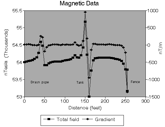 A total magnetic field and magnetic gradient profile over a buried drainpipe and tank.
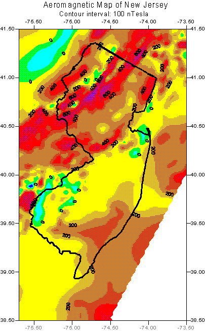 OFM 57, Magnetic Anomaly Map of New Jersey and Vicinity. Download PDF
NJGS DIGITAL GEODATA SERIES DGS04-3 Magnetic Anomalies of New Jersey
For more information on the magnetic method, please refer to Chapter 8 (Geophysical Techniques) of the NJDEP’s Field Sampling Procedures Manual, 2005.
Electrical Methods
Electrical methods include electrical resistivity, induced polarization (IP), and spontaneous or self potential (SP). Electrical surveys are used for mapping the geological framework of aquifers, locating concentrated plumes of ground-water contamination, mapping the subsurface thickness of unconsolidated sediments and the depth to consolidated bedrock, and mineral exploration.
The Electrical Resistivity method measures the apparent bulk electrical resistivity by injecting current into the ground through current electrodes that are grounded at the earth’s surface and measuring the difference of the electrical potential between the potential electrodes (see figure below). The amount of current (in amps) and the potential difference (in volts) is used to calculate the apparent resistivity (ohm-meters) at the midpoint of the array of the electrodes. Some common field arrays for the resistivity method are shown below.
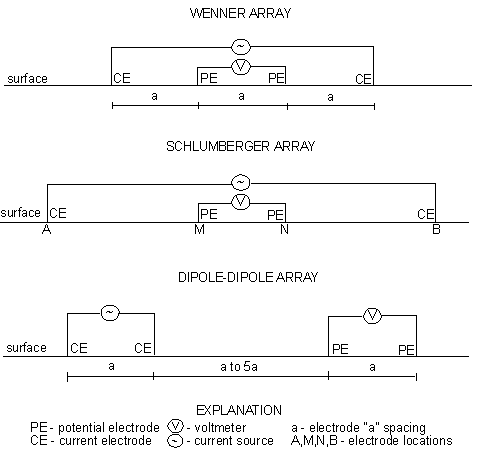
The Induced Polarization method measures the slow decay of voltage when the injected current is stopped. The IP method therefore measures the bulk electrical chargeability of the rocks. IP data are also collected using the field arrays shown above.
The Spontaneous Potential or Self Potential method measures the natural variation of the ground voltage between two electrodes. The voltage variation is caused by electrochemical reactions at a conductive body (for example a sulfide body).
For more information on geophysical techniques, please refer to Chapter 8 of the NJDEP’s Field Sampling Procedures Manual, 2005.
Electromagnetic Methods (EM)
Electromagnetic methods (EM) measure electrical currents generated in the subsurface resulting from the induction of time-varying magnetic fields at the ground surface. The EM method measures the bulk conductivity of subsurface material beneath and between the instruments transmitter and receiver coils. The readings are commonly expressed in the conductivity units of milli-ohms/meter (m-ohms/m) or milliseimens/meter (mS/m). EM Surveys are used for locating subsurface zones of highly-fractured bedrock, buried steel drums and tanks, plumes of ground-water contamination, and clay-rich horizons.
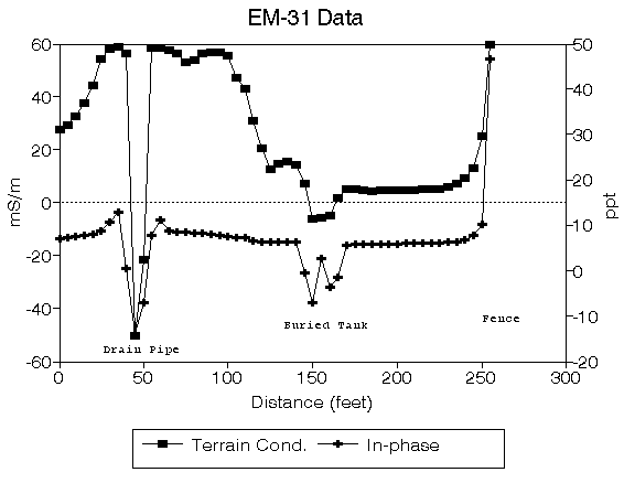
Terrain Conductivity
The terrain conductivity method uses co-planar transmitter and receiver coils with fixed separation. The exploration depth is generally increased by increasing the coil separation. The data are recorded in the frequency domain. Current flowing through the transmitter coil is set at a fixed frequency that varies as a sinusoidal function with time. Most EM instruments measure both the in-phase (real) and out-of-phase (quadrature) field components which are oriented normal to each other within the induced or primary magnetic field.
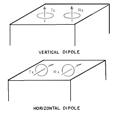
Diagram illustrating the coil configuration of a terrain conductivity study. Tx – transmitter coil, Rx – receiver coil.
Transient EM (TEM)
The “transient” or “time-domain” EM method records data in the time domain. The electrical current is induced for a period of time necessary to create a steady-state megnetic field in the earth. After this current is shut off, the secondary magnetic field associated with the induced current is sampled at a receiver as a function of time.
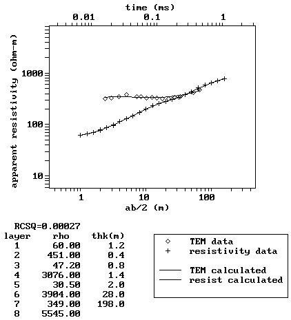
A modified display of the computer-graphics available with NJGS Open-File Report OFR 88-1 (Microcomputer Software for the Processing and Forward Modeling of Transient Electromagnetic Data Taken in the Central Loop Sounding Configuration).
Ground Penetrating Radar (GPR)
The GPR method uses a transmitting antenna to emit pulses of high-frequency EM waves into the subsurface. A transmitter and receiver apparatus is moved across the ground and the reflected EM energy is recorded as a function of time.
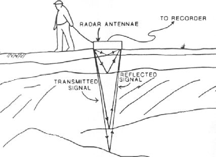
Diagram illustrating components of a GPR survey.
Very Low Frequency EM (VLF-EM)
The very-low frequency (VLF) EM method detects conductors by utilizing radio signals in the 15 to 30 kilohertz (kH) range that are used for military communications. The VLF transmitting stations are located worldwide. The most commonly used stations in North America are Annopolis, Maryland (21.4 kH), Cutler, Maine (24.0 kH) and Seattle, Washington (24.8 kH). Both of the in-phase (real) and out-of-phase (quadrature) components of the induced magnetic field are measured.
For more information on electrical methods, please refer to Chapter 8 (Geophysical Techniques) of the NJDEP’s Field Sampling Procedures Manual, 2005.
Seismic Methods
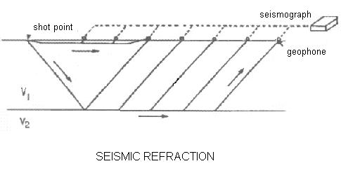
The seismic methods measure the travel-time of acoustic waves propagating through the subsurface. The shot point is the location of the source wave and the acoustic receivers are called geophones. Source waves are generally generated by percussion mechanisms located near the ground or water surface (for example dropped weights or dynamite). Data are collected, stored, and processed in a seismograph.
Seismic Refraction
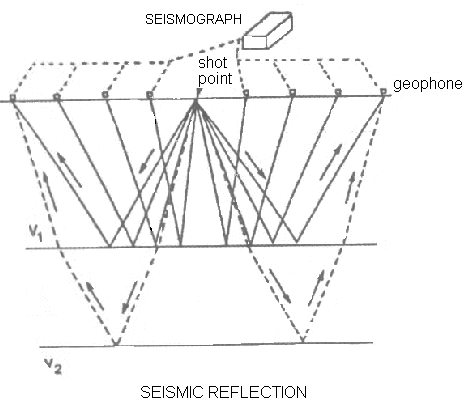
Seismic refraction is defined as the travel path of sound wave through an upper medium and along an interface (at a critical angle) and then back to the surface as shown in the figure below. The acoustic waves, like light waves, follow Snells’s Laws of Refraction.
 Seismic refraction surveys are commonly used to determine the thickness of unconsolidated materials overlying bedrock (overburden thickness) and depth to the water table. They are used for characterizing the geological framework of ground-water contamination studies and for assessing geologic hazards and archaeologic studies.
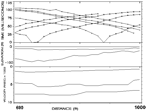 An example of seismic refraction data and interpreted model.
Seismic Reflection
The seismic reflection method records acoustic waves at the surface that are reflected off of subsurface stratigraphic interfaces where changes in the material density and conductive velocity of the acoustic waves are significant. The reflection patterns are described by Snell’s Laws of Reflection.
 Seismic reflection surveys are used for determining the thickness and structure of subsurface geology and are commonly applied in hydrocarbon and mineral exploration, earthquake and tectonic studies, and in the marine environment for resolving stratigraphic details (for example, the location and thickness of beach-sand deposits).
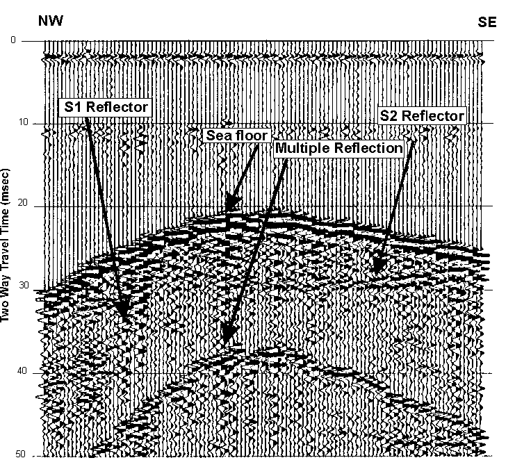 Digital marine seismic profile data traversing a sand ridge approximately 6 miles off of Avalon, New Jersey. The S2 reflector marks the sequence boundary between Holocene sediments and older Tertiary deposits. These depositional features are primary sources for beach sand replenishment.
For more information on geophysical techniques, please refer to Chapter 8 of the NJDEP’s Field Sampling Procedures Manual, 2005.
Gravity Method
The gravity method involves measuring the acceleration due to the earth’s gravitational field. A gravity meter or gravimeter measures the variations in the earth’s gravitational field. The variations in gravity are due to lateral changes in the density of the subsurface rocks in the vicinity of the measuring point. Because the the density variations are very small and uniform, the gravimeters are very sensitive and they measure one part in 100 million of the earth’s gravity field (980 gals or 980,000 milligals) in units of milligals or microgals.
Bouger Gravity Anomaly Map of New Jersey
Contour interval: 5 mgals
OFM 55, Bouguer Gravity Anomaly Map of New Jersey and Vicinity. Download PDF (541KB)
NJGS DIGITAL GEODATA SERIES DGS04-2 Bouguer Gravity Anomalies of New Jersey
Gravity Surveys are used for modeling the earth’s crustal structure, for locating bedrock fractures, buried topographic valleys, subsurface voids such as abandoned mines, caverns, and sinkholes, and for determining overburden thickness and depth to bedrock.
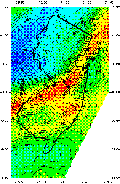
Gravity anomaly map over an abandoned mine.
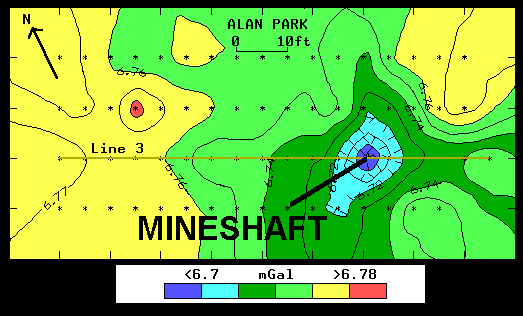
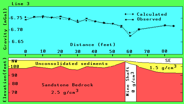
A gravity profile from above map and its interpreted model.
For more information on geophysical techniques, please refer to Chapter 8 “Geophysical Techniques” of the NJDEP’s Field Sampling Procedures Manual, 2005.
OFR 90-2 – Gravity Base Station Network in Northern New Jersey, Ghatge, Suhas L., and Jagel, Donald L., 1990, 39 p.
OFR 91-1 – Detection of an Abandoned Mine using High-Resolution Geophysical Methods in Randolph Township, Morris County, New Jersey, Ghatge, Suhas L., and Waldner, Jeffrey S., 1991, 10 p.
Microgravity Method for the Detection of Abandoned Shafts of the Schuyler Mine in Northeastern New Jersey, Ghatge Suhas L., 1993, Proceedings of the Symposium on the Application of Geophysics to Engineering and Environmental Problems (SAGEEP 1993), April 18-22, 1993, San Diego, California.,Vol. 1, pp. 195-207.
Microgravity Method for detection of Abandoned Mines in New Jersey, Ghatge, Suhas L., 1993, Bulletin of the Assoc. of Engineering Geologists, Vol XXX, No. 1, 1993, pp.79-85.
Borehole Geophysical Methods
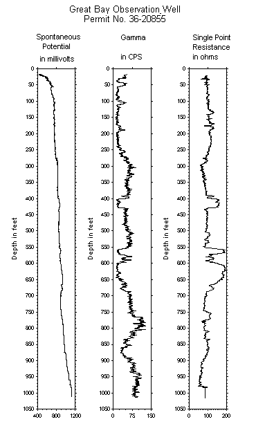
The various borehole geophysical tools used for logging wells employ the same geophysical principles as for the surface methods. The most common tools include natural gamma ray, self potential, resistivity, induction, porosity/density, and caliper devices.
Borehole geophysics is used for mapping the hydrogeologic framework of an aquifer, locating concentrated plumes of ground-water contamination, and identifying other subsurface features such as natural-occurring voids and radioactive horizons.
Sample of a geophysical log.
For more information on borehole geophysical methods, please refer to Chapter 8 (Geophysical Techniques) of the NJDEP’s Field Sampling Procedures Manual, 2005.