Digital Data
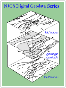 The Digital Geodata Series (DGS) are a set of digital data files that can be retrieved using Internet browsers for the World-Wide-Web. The Series includes DGS products and other reference and utility files. DGS products include data sets compiled for use in Geographic Information System (GIS) software, and other software applications stemming from Survey projects. DGS products for GIS include ESRI‘s™ ARC/INFO exported coverages (e00) and GRIDs, Arc Marco Language (AML) scripts and form menus, ArcView 3.x shapefiles, and geodatabases. Other DGS products include georegistered bit map and raster imagery, Microsoft Excel workbooks, Microsoft Access databases, executable software programs, FGDC compliant metadata files, and other ASCII text files providing references, specifications, and notes.
DGS files are reviewed according to standards for the Survey Open-File products. They are provided here at no cost as compressed or archived binary files MIME type multipart/x-zip or multipart/x-tar). Some browsers may have to be configured to download a file using these MIME (Multimedia Internet Mail Extensions) protocols.
Pursuant to the NJ Department of Environmental Protection GIS data-sharing policy, any maps, publications, reports, or other documents that utilize NJDEP digital data will credit the NJDEP’s Geographic Information System as the source of the data with the following credit/disclaimer:
   "This (map/publications/report) was developed using New
   Jersey Department of Environmental Protection Geographic
   Information System digital data, in conjunction with the DATA
   USER's work, but this secondary product has not been verified
   by NJDEP and is not state-authorized."
Data from the Digital Geodata Series are also available for distribution upon written request to the State Geologist. These data include topographic base-map imagery and other utility data that can be supplied in response to custom orders with costs reflecting data preparation and reproduction.
DGS07-3 Bathymetric Digital Elevation Grids Offshore of New Jersey
DGS06-1 Bathymetric Elevation Contours Offshore of New Jersey (Ten-Foot Interval)
DGS00-3 Topographic Elevation Contours for New Jersey (1:100,000 Scale)
DGS99-4 Digital Elevation Grids for New Jersey (1:100,000 scale)
DGS99-1 Monochromatic Bit-Mapped Topographic Images of New Jersey (1:24,000 scale)
DGS98-7 County Topographic Base Map Digital-Raster-Graphics Images for New Jersey (1:100,000 scale)
DGS98-4 A 30-Second State Plane Coordinate Grid for New Jersey
DGS98-3 Monochromatic Bit-Mapped Topographic Images of Hunterdon County, NJ. Superceded by DGS99-1
DGS98-2 Monochromatic Bit-Mapped Topographic Images of Warren County, NJ. Superceded by DGS99-1
DGS98-1 Monochromatic Bit-Mapped Image of New Jersey; Planimetric Base Map (1:500,000 scale)
DGS17-1, Oil and Natural Gas Exploration Wells Drilled in New Jersey
DGS15-2 Soil, Liquefaction and Landslide Susceptibility in New Jersey
DGS15-1 Bedrock Geology of New Jersey (Scale 1:24,000)
DGS10-2 Surficial Geology of New Jersey (Scale 1:24,000) updated (12-04-2018)
DGS10-3 New Jersey Transfer Model Withdrawal, Use, and Return Data Summaries
DGS09-2 Coastal Plain Sediments with Potential to Form Acid (Sulfate) Soils
DGS07-2 Surficial Geology of New Jersey (Scale 1:100,000)
DGS06-3 Landslides in New Jersey updated (5-1-2017)
DGS05-1 Selected Sand, Gravel and Rock Surficial Mining Operations (quarries) in New Jersey
DGS04-7 Historic Fill For New Jersey updated (4-15-2025)
DGS04-6 Bedrock Geology of New Jersey (Scale 1:100,00)
DGS04-1 Earthquakes Epicentered in New Jersey updated (6-28-2023)
DGS03-2 Abandoned Mines of New Jersey (Scale 1:24,000)
DGS02-7 Physiographic Provinces of New Jersey
DGS00-5 ArcView 3.X Extension for Making 2D and 3D Structural Geologic Shapefiles
DGS99-3 Surficial Geology of Hunterdon County, New Jersey (1:24,000)
DGS97-2 Surficial Geology of Middlesex County, New Jersey (1:24,000)
DGS96-4 NJGS Field Data Management System (v.2.1)
DGS96-2 Bedrock Geology of Warren County, New Jersey (1:48,000)
DGS96-1 Glacial Sediments of New Jersey (Scale 1:100,000)
DGS18-1 Springs In New Jersey. Associated with OFR21-3 updated (4-24-2019)
DGS14-1 Computer Workbook Investigating Water Availability in New Jersey on a Watershed Management Area Basis updated (9-8-2014)
DGS13-1 Computer Workbook Summarizing New Jersey Withdrawals and Discharges on a HUC11 Basis updated (8-28-2023)
DGS10-3 New Jersey Water Transfer Model Withdrawal, Use, and Return Data updated (10-27-2022)
DGS10-1 Dielectric Permittivity as a Function of Water Content For Selected New Jersey Soils
DGS09-1 Reservoir Storage and Related Diversions in the Passaic and Hackensack River Basins, 1898 to 2015 updated (10-30-2017)
DGS08-1 Canals and Water Raceways of New Jersey
DGS07-1 Aquifer-Recharge Potential for New Jersey
DGS06-2 Tidal Benchmark Network in New Jersey
DGS05-3 Hydrogeologic Nomenclature Reference Table
DGS05-2 New Jersey’s Ambient Ground Water Quality Network Data
DGS04-9 New Jersey water withdrawals, transfers, and discharges by Watershed Management Area, 1990-1999
DGS04-8 Summary of Flows in the Delaware River at Trenton and Montague with Major Upstream Diversions, 1913-2002
DGS04-5 Well Head Protection Areas For Public Non-Community Water Supply Wells In New Jersey.
DGS02-6 A Recharge-Based Nitrate-Dilution Model for New Jersey, V6.0
DGS02-5 Selected U.S. Geological Survey and N.J. Department of Environmental Protection Monitoring Networks
DGS02-4 Additional Climate Factors for the New Jersey Geological Survey’s Ground-Water Recharge Methodology
DGS02-3 Ground-Water Recharge for New Jersey
DGS02-2 Well Head Protection Areas for Public Community Water Supply Wells in New Jersey
DGS02-1 New Jersey Geological Survey Hydro Database
DGS01-2 Relational Data Files for GIS Display of New Jersey Water Withdrawals from 1990 to 1999
DGS01-1 ArcView 3.x Extension for 3D Well-Field Generation and Visualization
DGS00-4 Data Summary of New Jersey Water Withdrawals 1990-1996. Superseded by DGS04-9
DGS00-2 Areas of Counties and Municipalities in Water Regions and Watershed Management Areas for New Jersey
DGS00-1 Drought Regions in New Jersey
DGS99-2 MS Excel Workbook Implementing the NJGS Ground-Water-Recharge Methodology
DGS98-6 Sole-Source Aquifers of New Jersey (1:100,000)
DGS98-5 Bedrock Aquifers of New Jersey (1:250,000)
DGS98-5 Surficial Aquifers of New Jersey (1:250,000)
DGS97-1 Public-Community Water-Supply Wells of New Jersey
DGS96-3 Ambient Ground-Water Quality of the New Jersey Part of the Newark Basin
Some data from the Digital Geodata Series are displayed in the following interactive tools:
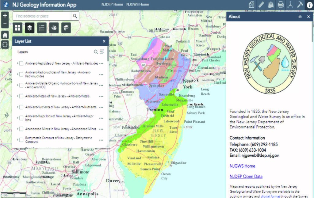
NJ Geology Information Web App
An interactive mapping application that provides information specific to New Jersey’s geology, aquifers, well head protection areas, earthquake epicenters, abandoned mines, landslides.
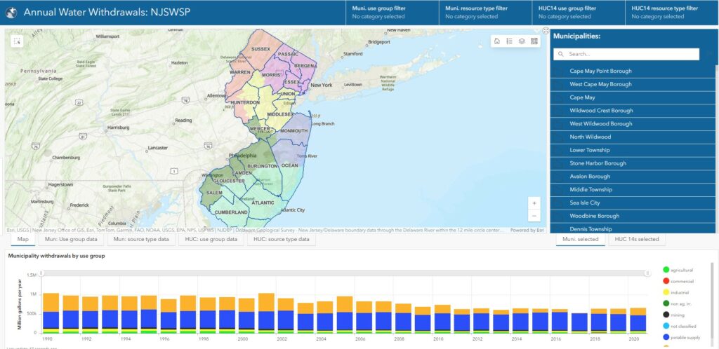
NJ Water Withdrawl Data Summary Viewer
This viewer displays New Jersey water withdrawals categorized by use group and resource type. Withdrawal data is summarized by municipality and HUC 14 in related tables. This data is designed to support the sharing of water supply planning information with the public and is a component of the statewide water supply plan update
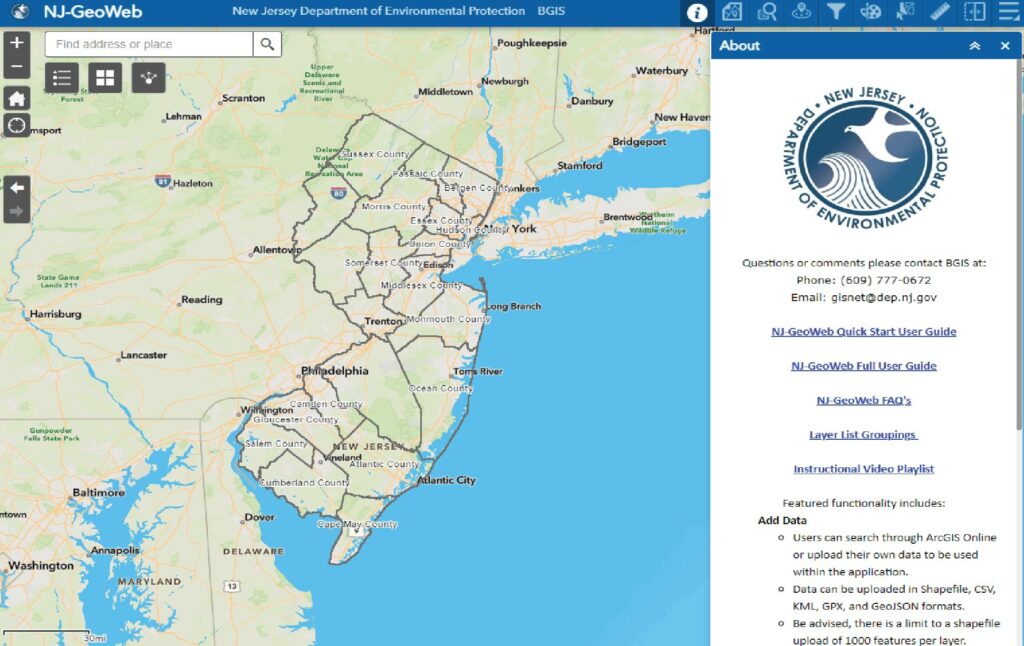
NJ-GeoWeb 3.0
An interactive mapping application that can be used for locating areas of interest, interacting with the Department’s GIS data, and querying related environmental information.
Experience Builder & StoryMaps
ArcGIS StoryMaps allow you to share your maps in the context of narrative text and other multimedia content.
New Jersey Publicly Accessible High Points by County
Deepest Bodies of Water in New Jersey