 Official Site of The State of New Jersey
Landscape Project Story Map
An overview of the Landscape Project methodology and changes made for Landscape Project 3.4
Landscape Project Experience
Access Landscape Project GIS layers with the Landscape Project Experience application
Both the Experience and StoryMap work best with Google Chrome browser
What is the Landscape Project?
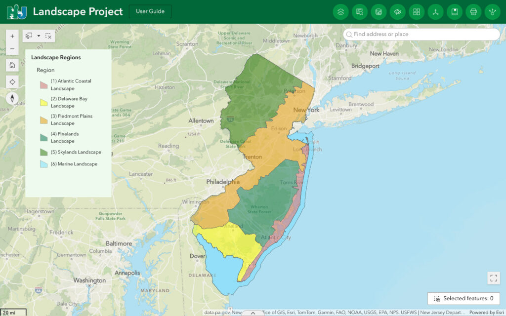
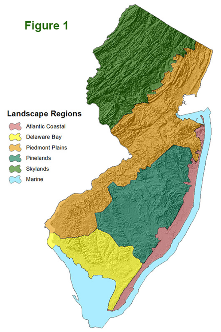
The Landscape Project is a pro-active, ecosystem-level approach for the long-term protection of imperiled species and their important habitats in New Jersey. The project was begun in 1994 by the N.J. Division of Fish Wildlife’s Endangered and Nongame Species Program (ENSP). The Landscape Project focuses on large land areas called “landscape regions” that are ecologically similar regarding their plant and animal communities (Figure 1). Using an extensive database which combines imperiled and priority species location information with land-use/land-cover data, the Endangered and Nongame Species Program has identified and mapped areas of critical importance for imperiled species within each landscape region.
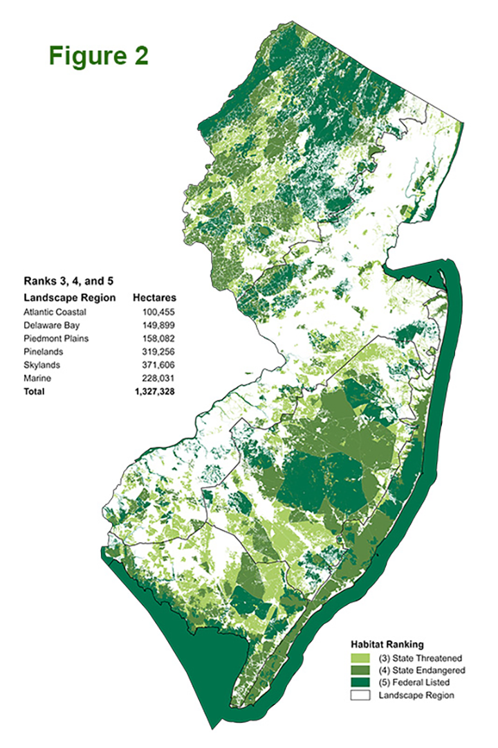
Landscape Project critical habitat maps (Figure 2) were developed to provide users with peer-reviewed,scientifically-sound information that is easily accessible. Critical habitat maps were designed for use by anyone, but especially those individuals and agencies who have the responsibility for making land-use decisions, i.e., municipal and county planners and local planning boards, state agencies, natural resource and lands managers, the general public, etc.
Most importantly, the critical information Landscape Project products provide can be used for planning purposes before any actions, such as proposed development, resource extraction (such as timber harvests) or conservation measures, occur. Proper planning with accurate, legally and scientifically sound information will result in less conflict. Less time will be wasted, and less money spent, attempting to resolve endangered and threatened species issues.
Why does NJ need the Landscape Project?
As the most densely populated state in the nation, pressure to consume land for development has increased as the population has grown. Yet population growth cannot be isolated as the only, or even the primary, driving force of habitat loss in New Jersey as urbanization continues to occur at a greater rate than population growth. Land was consumed for residential development at nearly twice the rate of population growth over the 1986-2007 period, widely a result of a large-lot, area-intensive land use zoning and development pattern that encroached on rural landscapes throughout the state (Hasse & Lathrop 2008, 2010; Hasse et al. 2010). In more recent years, residential development decreased its relative contribution to overall urbanization while industrial, transportation, major roadways and other urban or built-up land experienced relative increases (Hasse & Lathrop 2020).
Whether this uptick indicates old development patterns regaining a foothold, or simply represents a minor fluctuation of a lower urbanization rate in place since 2007, remains to be seen. Nevertheless, the Landscape Project dataset remains integral to many regional planning efforts that encourage smart growth and it will continue to serve as a tool to help facilitate land use patterns more sensitive to the needs of wildlife and their habitats.
Who benefits from the Landscape Project?
Conservation of large expanses of fields, forests and wetlands help to ensure that wildlife will remain a part of New Jersey’s future. Conserving imperiled and special concern species habitat identified in the Landscape Project also results in more land contributing ecosystem services and more open space for outdoor recreation. Surveys by the US Fish and Wildlife Service (2024) reveal more than 148 million U.S. residents sixteen and older participate in some form of wildlife-related recreation. Open spaces provide places where people can escape the confines and stresses of urban and suburban living. Retaining habitats in their natural state provides other benefits such as reducing the threat of flooding, allowing for the biodegradation and filtering of environmental contaminants and recharging ground water reserves. In short, planning that employs the Landscape Project habitat mapping provides potential benefits for everyone.
Download Landscape Project GIS Data
Critical wildlife habitat maps can be downloaded from NJDEP Bureau of GIS website. (more )
Read New Jersey’s Landscape Project Report
The following reports provide in-depth information about the Landscape Project, the methodology used to delineate and rank habitat, and the peer-review and working groups that assisted in development of the methodology.
New Jersey’s Landscape Project Report (Version 3.4)
New Jersey’s Landscape Project Poster (Version 3.4)
Appendices to Landscape Project Report (Version 3.4)
- Appendix I – Protocol for Accepting or Rejecting Species Sighting Reports
- Appendix II – Species Occurrence Area Justifications
- Appendix III – NJDEP 2020 Land Use/Land Cover Categories
- Appendix IV – Land Use/Land Cover Analysis for Species and their Feature Label Components
- Appendix V – Land Use/Land Cover Selections and Patch Type Justifications