The New Jersey Partnership to Plug-In
On June 3, 2019, Governor Murphy announced the New Jersey Partnership to Plug-in, a first-of-its-kind, statewide partnership to build out the necessary infrastructure to support electric vehicles in New Jersey. The Partnership aligns state agency roles through a Memorandum of Understanding (MOU) that requires the goals of the partnership be incorporated in the RGGI Strategic Funding Plan, and directs the Agencies to use the RGGI funds, to extent authorized by law and regulation, to further the MOU goals.
COORDINATION WITH EFFORTS OF THE BOARD OF PUBLIC UTILITIES, THE DEPARTMENT OF ENVIRONMENTAL PROTECTION, AND THE ECONOMIC DEVELOPMENT AUTHORITY
“The New Jersey Partnership to Plug-In ensures that we are working collaboratively across state agencies and with our private sector partners, to not only meet, but exceed our goal of registering 330,000 electric vehicles in New Jersey by 2025,” said Governor Murphy. “This new initiative is part of our broader effort to make renewable energy solutions work for everyone in New Jersey”
ELECTRIC VEHICLE REGISTRATION MAPPING
Current and Projected Electric Vehicle Registrations
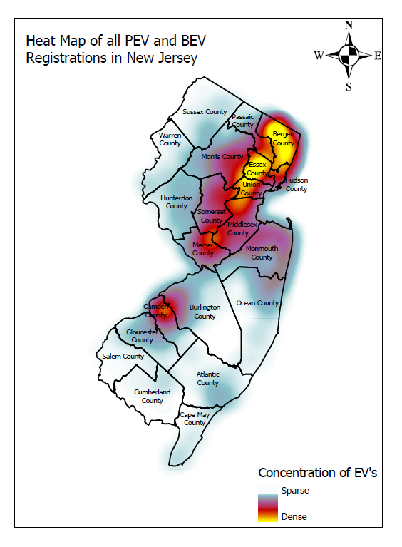
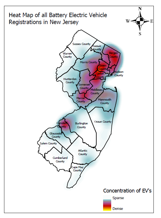
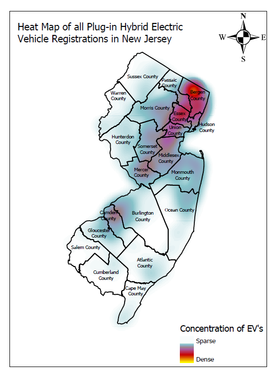
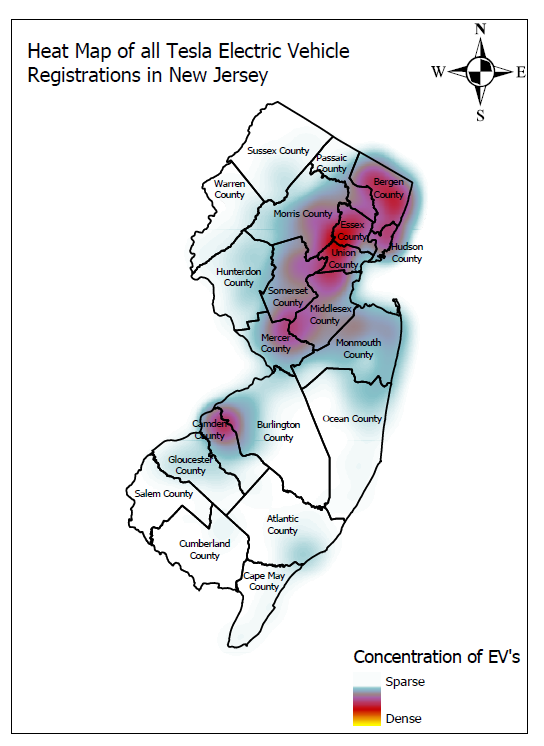
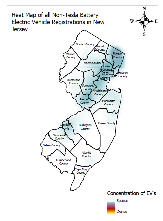
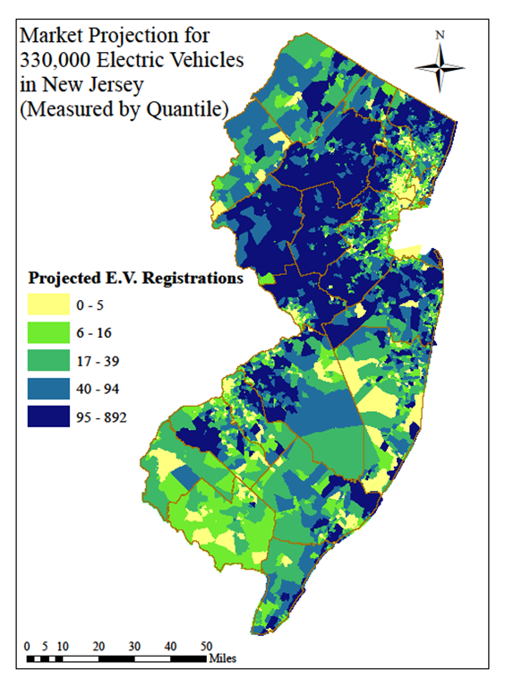
In addition to the strategic mapping, above, current and projected EV registration density may be used to evaluate suitability of potential charging station locations. Not all of the electric vehicle types shown on the maps will be relevant to eligible charging station projects under the EV Law (for example, plug-in hybrid electric vehicles are generally incompatible with DCFC, and Tesla-only charging stations do not meet the EV Law requirements). These maps are for informational purposes only and based on data current through December 31, 2019.
The following New Jersey maps show:
ELECTRIC VEHICLE INFRASTRUCTURE CORRIDOR STRATEGIC MAPPING
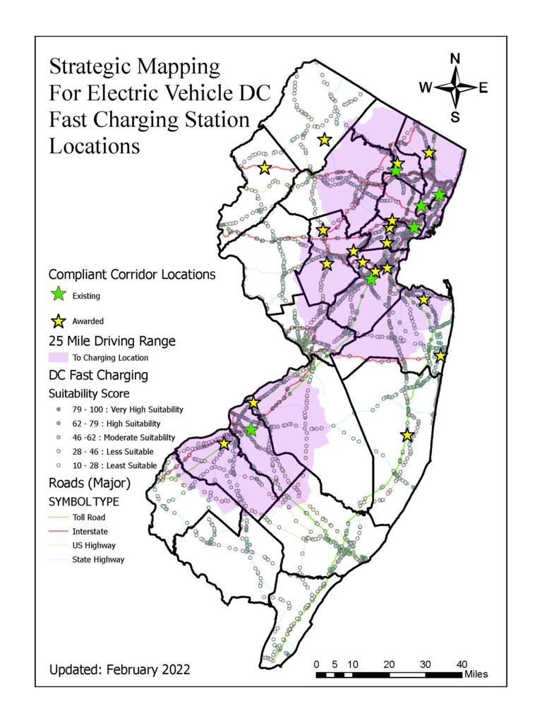
In accordance with the New Jersey Partnership to Plug-In, “Partnership” (signed June 3rd, 2019), the Department is developing mapping that that will help inform strategic placement of electric vehicle (EV) charging infrastructure. Further, Public Law 2019, chapter 362, “EV Law” (signed January 17th, 2020), prescribes more specific requirements for EV charging infrastructure, with regard to number, power, and distribution of charging stations. This initial phase of the Department’s effort focuses on DC fast charging (DCFC) on major travel corridors in New Jersey. The EV Law requires at least 75 charging locations on travel corridors, equipped with at least two DCFCs per location, each capable of providing at least 150 kW of power, and no more than 25 miles between charging locations. The EV Law also requires that fast charging equipment at these 75 locations comply with CHAdeMO, CCS, or other non-proprietary future standards (i.e., Tesla Superchargers are not compliant). These are referred to in the map as “compliant locations.”
INTERPRETING THE MAP
The map is labeled, “Strategic Mapping For Electric Vehicle DC Fast Charging Station Locations.” This map incorporates several layers of information:
1. The base map of New Jersey shows county boundaries and major roads.
2. Current DCFC locations that are compliant with the EV Law are shown as green stars. Planned (near term) DCFC locations that are also compliant with the EV law are shown as yellow stars. The 25 mile driving distance to the green stars is portrayed as a light purple layer.
3. However, in addition to the map, the Department is also providing a list of all New Jersey toll roads, interstates, US routes and NJ routes that are at least 20 miles in length, with an estimated number of potential DCFC locations (118) that would be required on each roadway if such locations were spaced every 25 miles, as required by the EV Law. A subset of this list of 118 will enable us to attain the goal of 75, as required by the EV Law.
The final layer is a suitability score derived from the publicly-available M.J. Bradley & Associates “Electric Vehicle Infrastructure Planning Tools” as detailed in our methodology document. The darker color dots on the map indicate corridor locations at intersections or exits with a higher suitability score for the placement of DCFC. To provide more detailed information than visible on the map, you may also view a complete list of the suitability scores here.
This strategic mapping provides information that allows for evaluation of potential DCFC locations as follows:
1. Areas on the map that are not shaded purple or blue are not covered by a DCFC location that is compliant with the EV Law. DCFCs installed outside of the shaded areas would help to provide gap coverage. However, additional locations will also be needed inside the shaded areas in order to meet the requirement of 75 locations.
2. Exits and intersections with a higher suitability score offer higher population, more traffic, and more nearby commercial amenities, making these potentially more desirable for DCFC locations.
