About Wetlands
Previously misunderstood as wastelands, wetlands are now being recognized for their vital ecological and socioeconomic contributions.
Did you know Wetlands:
- Protect drinking water by filtering out chemicals, pollutants, and sediments that would otherwise clog and contaminate our waters.
- Soak up runoff from heavy rains and snow melts, providing natural flood control. Wetlands release stored flood waters to streams during droughts.
- Provide critical habitats for a major portion of the State’s fish and wildlife, including endangered, commercial and recreational species.
- Provide high quality open space for recreation and tourism.
Many of these values were not widely appreciated until the 1970s and 1980s. By then, more than half of the nation’s wetlands were destroyed.
Definition of a Wetland
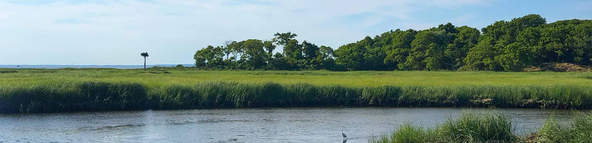
A wetland is a unique ecosystem where the land is regularly saturated with water for an extended period of time. There are a variety of types of wetlands, such as bogs, marshes, and swamps, but all wetlands have three essential characteristics in common:
Water
In a wetland, the water level will be at, above, or just below the surface of the ground for some duration of time at least once per year. A wetland does not have to be wet constantly. Some wetlands retain this high amount of water throughout the entire year while others will only be wet during certain intervals, such as during a particular season. The water in a wetland might come from a nearby waterway (such as the ocean, a river, a stream, or a creek) or from precipitation. It could also seep up from below the surface of the ground. The different traits of the water in a wetland (quantity, timing, source, etc.) are collectively referred to as the wetland’s hydrology. “Hydrology” means the study of water.
Saturated Soil
Wetlands have a particular type of soil called hydric soil. “Hydric” means wet. All soil gets wet from time to time, but hydric soils are wet long enough that they become anaerobic, meaning there is no oxygen in them. The longer that soil is saturated with water, the less oxygen it has. Hydric soil is generally darker in color than regular soil and sometimes has red, green, or purple tones, which indicate a lack of oxygen.
Water Plants
While all plants need water, certain species of plants have adapted to survive in hydric soils and flooded conditions. These species are often referred to as hydrophytes or hydrophytic vegetation. “Hydrophyte” is Greek for “water plant.” Hydrophytes come in all different forms. Some wetlands will be mostly grassy, others are covered primarily in shrubs, and some are forested with large trees.
Wetlands are found throughout New Jersey, and they can be either tidal or non-tidal. Tidal wetlands are routinely flooded by the tides of the ocean, rivers, streams, and bays in New Jersey’s Coastal Zone and are usually referred to as coastal wetlands. The water in coastal wetlands can be saltwater or a mix of salt and freshwater. Non-tidal wetlands in New Jersey are referred to as freshwater wetlands, and they can be found throughout the state, often along non-tidal streams, rivers, and creeks. However, freshwater wetlands can also be found in low-lying areas far from any waterway. The water in these wetlands typically comes from precipitation or groundwater.
Why is Protecting Wetlands Important?
Wetlands are an extremely valuable natural resource that provide essential benefits for people, animals, and the environment. Wetlands purify our water by filtering out harmful pollutants that would contaminate our waterways, and they protect us against flooding by soaking up water during storms. Along the coast, wetlands help prevent erosion. The roots of wetland plants hold in soil and sand so that the wind and water cannot sweep the soil or sand away with them.
Wetlands also help protect us from climate change by absorbing excess carbon dioxide from the air. Carbon dioxide traps heat close to the Earth, which is necessary to keep us warm. However, when there is too much carbon dioxide in our atmosphere, Earth’s temperature rises too high, melting the polar ice caps and pushing more water into our oceans, which causes sea levels to rise. High atmospheric temperatures also lead to more precipitation, which means longer and more frequent storms that can lead to increased flooding. However, plants are nature’s solution to climate change. Plants need carbon dioxide to grow, so they remove it from the air. The types of plants found in wetlands are especially useful for mitigating against climate change as they absorb carbon dioxide very quickly and hold onto excess carbon for a long time, which helps keep our atmosphere from overheating.
In addition to these benefits, wetlands are crucial for numerous animal species throughout New Jersey, many of which live, feed, spawn, and/or nest in wetlands. Wetlands also provide great recreational spaces for people. We go to wetlands to hunt, fish, canoe, kayak, look at wildlife, take pictures, and hike.
The DEP has produced its first scientific report on climate change, which summarizes the current state of knowledge regarding the effects of climate change on New Jersey’s environment.
Unfortunately, wetlands in New Jersey are highly vulnerable to both human and natural forces, especially sea level rise and development pressure. As the most densely populated state in the nation, New Jersey is subject to high demands for development to accommodate its growing population. Thousands of acres of wetlands have already been lost to development. Both coastal and freshwater wetlands are also threatened by our rising sea levels. Coastal wetlands are at risk from drowning while some freshwater wetlands may be destroyed by an influx of saltwater.
How Does DEP Protect Wetlands?
The DEP strives to protect wetlands through a variety of methods, including research, planning, public involvement, permitting, mitigation, and education. The DEP also works to protect the wide variety of plants and animals that live in our state’s coastal and freshwater wetlands.
WLM oversees wetlands permitting and mitigation. WLM also helps ensure the protection of threatened and endangered species that call New Jersey’s wetlands home and contributes to the DEP’s wetlands education programs.
Finally, WLM plays a role in the efforts undertaken by the New Jersey Coastal Management Program (NJCMP) to protect coastal and freshwater wetlands within our state’s Coastal Zone. The NJCMP is comprised of a network of offices within the DEP that work together to ensure that New Jersey’s coastal resources and ecosystems, including wetlands, are conserved as a vital part of local, state, and federal efforts to enhance sustainable coastal communities.

To ensure the protection of our wetlands, a permit or approval is required for any activity that may impact this critical and vulnerable ecosystem. There are three categories of permits and approvals for wetlands – coastal wetlands permits, freshwater wetlands permits, and transition area waivers.
The Wetlands Act of 1970 required the creation of maps showing the boundaries of all coastal wetlands within New Jersey from the Raritan Bay south. These coastal wetlands maps were completed in the early 1970s. All mapped wetlands are considered coastal wetlands for permitting purposes, even if the wetland is not tidal today. Wetlands are a dynamic ecosystem, and both coastal and freshwater wetlands in New Jersey have undergone changes since the maps were produced. Any activity that is located in a mapped coastal wetland may need a coastal wetlands permit. Mapped coastal wetlands are protected as part of New Jersey’s Coastal Zone, so coastal wetlands permits are included in the coastal zone permitting program. See Coastal Permitting for more information.
Any activity located within a wetland that is not mapped on the coastal wetlands maps may require a freshwater wetlands permit, even if the wetland is tidal.
DEP staff reviews permit applications for construction within wetlands and transition areas according to the following statutes and rules. For more information on each of these, see Laws and Regulations.
WLM has created an online mapping tool to help you identify if your project is in a protected area, such as a coastal or freshwater wetland or transition area, as well as other related environmental features and resources that may affect your proposed project.
To ensure the health and safety of certain wetlands, New Jersey also protects the land areas adjacent to the wetland, which are called transition areas. In transition areas, a special approval called a transition area waiver is necessary to ensure the protective boundary surrounding the wetland is maintained.
Common types of activities that require a freshwater wetlands permit or transition area waiver include construction activities (such as houses and swimming pools), disturbances to the soil (such as excavation), disturbances to the water level (such as draining or ditching), the dumping of materials (such as filling), and disturbances to the vegetation (such as cutting down trees or spraying herbicide).
Types of Freshwater Wetlands Permits and Transition Area Waivers
Several types of freshwater wetlands permits are available, depending on the project. These include general permits-by-certification, general permits, and individual permits. For more information on each of these types of permits and approvals, see Permit Types.
Below you will find lists of the general permits-by-certification and general permits that are available for freshwater wetlands. If your project is not listed below, it is likely that you will need an individual permit. WLM has created a checklist for individual permits that provides the application requirements.
Within transition areas, several types of transition area waivers are available, depending on the project. These are also listed below.
General Permits-by-Certification:
There are two activities that may be eligible for a freshwater wetlands general permit-by-certification. The table below provides a brief description of each permit. For detailed information and the specific requirements for each general permit-by-certification, see Subchapter 6 of the Freshwater Wetlands Protection Act Rules.
- General permit-by-certification 8 – Construction of an addition to a lawfully existing residential dwelling
- General permit-by-certification 24 – Repair or modification of a malfunctioning individual subsurface sewage disposal (septic) system
General Permits:
There are 30 freshwater wetlands general permits. The table below organizes these general permits into distinct categories and provides a brief description of each permit. For detailed information and the specific requirements for each general permit, see Subchapter 7 of the Freshwater Wetlands Protection Act Rules.
WLM has created checklists for each of these general permits. Each checklist provides the application requirements for that general permit.
Transition Area Waivers:
There are five types of transition area waivers. The table below provides a brief description of each waiver. For detailed information and the specific requirements for each transition area waiver, see Subchapter 8 of the Freshwater Wetlands Protection Act Rules.
WLM has created checklists for these transitions area waivers. Each checklist provides the application requirements for that waiver.
- General permit transition area waiver – If the activity qualifies for one of the general permits listed above (except for general permits 1, 6, 7, and 23), the general permit serves as the transition area waiver. Please note that there is no separate checklist for a general permit transition area waiver. The application requirements for the waiver are the same as the requirements for the general permit.
- Special activity transition area waiver – This transition area waivers applies only to certain stormwater management activities (such as outfalls), linear development activities (such as roadways and pipelines), and redevelopment activities (such as building a residential development where there was once an industrial development) as well as activities that would meet the criteria for an individual permit if they were located within a freshwater wetland instead of within a transition area.
- Averaging plan transition area waiver – If an activity does not qualify for the general permit transition area waiver or the special activity transition area waiver, the averaging plan transition area waiver may apply. Under this waiver, the overall shape of the transition area is modified to allow for the proposed activity. However, the total square footage of the transition area must be maintained to ensure there is no reduction in the size of the protected area around the wetland.
- Access transition area waiver – This waiver is for activities that are located in a freshwater wetland that require either a general permit or an individual permit as well as for mitigation activities. The waiver allows limited access through the transition area for the construction and/or use of the activity within the wetland. For example, an access transition area waiver would allow for the temporary storage of construction materials within the transition area.
- Hardship transition area waiver – This transition area waiver may be used for an activity only if complying with all of the requirements in the Freshwater Wetlands Act Rules would make any development on the site impossible.
Delineating Freshwater Wetlands – Obtaining a Letter of Interpretation
Wetlands are commonly referred to as swamps, marshes, or bogs, however many wetlands in New Jersey do not fit this familiar description. A wetlands may be appear to be dry on the surface for much of the year but be wet in the spring or during storm events. To determine what is and is not a wetland in New Jersey, the Department has adopted and requires that the 1989 Federal Manual for Identifying and Delineating Jurisdictional Wetlands be used for determining the presence and extent of freshwater wetlands.
The 1989 Federal manual uses a three parameter approach and requires that a wetland include; hydric soils, wetland hydrology and hydrophytic vegetation. For detailed information, and for exceptions to this approach, please download and carefully review the 1989 Federal Manual.
A “Letter of Interpretation” or “LOI” means a document “…issued by the Department under N.J.A.C.7:7A-4, indicating the presence or absence of wetlands, State open waters, or transition areas; verifying or delineating the boundaries of freshwater wetlands, State open waters, and/or transition areas; or assigning a wetland a resource value classification.” There are five types of LOI’s obtainable from the Department;
- Presence/Absence
- Presence/Absence – “Footprint” of Disturbance
- Delineation
- Verification
- Verification – Partial
The following regulations apply to all Letters of Interpretation.
- N.J.A.C 7:7A – The entire Freshwater Wetlands Protection Act Rules.
- N.J.A.C. 7:7A-4 See this section for regulations that apply to all Letters of Interpretation.
- N.J.A.C. 7:7A-16.2 See this section for general application requirements
- N.J.A.C. 7:7A-16.3 See this section for application requirements for Letters of Interpretation
Please Note: The Department has made every effort to ensure that the text of this regulation is identical to the official, legally effective version set forth in the New Jersey Register. However, should there be any discrepancies between the text in the PDF available on this web site and the official version of the rule, the official version will govern. For more information on obtaining official versions of the rules, How To Get a Paper Copy of Department Rules
Letter of Interpretation
If you wish to have clear knowledge of whether there are freshwater wetlands, freshwater wetlands transition areas and/or State open waters on a site, you will have to apply for a Letter of Interpretation (LOI). Wetlands mapping available on GEOWEB and from other sources is an approximation usually based on aerial photography interpretation. The true extent of wetlands on a site may be less, or than is depicted on these maps and if present may be of a very different configuration. The State does not rely on these maps for regulatory determinations and instead requires a LOI should someone wish to determine presence, absence and/or extent of wetlands on a parcel(s).
Presence/Absence
A “Presence/Absence” LOI identifies whether any freshwater wetlands, State open waters or transition areas exist on a site, or on a portion of a site (See “Footprint of Disturbance” below) one acre or less. A presence/absence LOI also provides the resource value classification for any wetlands on the site.
A presence/absence LOI does not identify the boundaries or location of any freshwater wetlands, transition areas, and/or State open waters found within a site or portion thereof. To obtain an LOI indicating the location or the boundaries of freshwater wetlands, transition areas, and/or State open waters, an applicant must apply for a Line Delineation LOI (See the Delineation tab) for sites of up to an acre, or a line verification LOI (See the Verification tab) for sites over an acre.
The Department can issue a presence/absence LOI for any site, regardless of its size. Please see N.J.A.C. 7:7A-4.3, Presence/absence LOI, for the relevant section of the rules Application requirements for a LOI can be found in the “Freshwater Wetlands” tab of the “Forms, Checklists and Other Documents” webpage and at N.J.A.C. 7:7A-16.3.
Presence/Absence – Footprint of Disturbance
A “Footprint of Disturbance” (FOD) LOI identifies whether any freshwater wetlands or State open waters exist within a defined “footprint” on a subject site or whether a transition area from an adjacent wetland is within the footprint, with the following restrictions:
- The footprint area must be no larger than one acre.
- The Department will issue a FOD for more than one portion of a site, provided that:
- Each portion is no larger than one acre;
- The applicant submits a separate fee for each portion; and
- No more than three presence/absence LOIs shall be issued for a single site under this subsection.
Please see N.J.A.C. 7:7A-4.3, Presence/absence LOI, and specifically N.J.A.C. 7:7A-4.3(c) and (d), for the relevant rule provisions. Application requirements for a LOI can be found in the “Freshwater Wetlands” tab of the “Forms, Checklists and Other Documents” webpage and at N.J.A.C. 7:7A-16.3.
Wetland Delineations
A “Line Delineation” LOI identifies the boundaries of any freshwater wetlands, transition areas, and/or State open waters on a site or a municipal tax lot that is one acre or smaller, and identifies the resource value classification of any freshwater wetlands on the site. For a line delineation LOI, the applicant need not submit a delineation. Rather, the Department will inspect the site and delineate the boundary lines of any freshwater wetlands, transition areas, and/or State open waters. You cannot get a Line Delineation LOI for a portion of a site, unless the portion is an entire municipal tax lot. Please see N.J.A.C. 7:7A-4.4,Line delineation LOI for the relevant section of the rules. Application requirements for a LOI can be found in the “Freshwater Wetlands” tab of the “Forms, Checklists and Other Documents” webpage and at N.J.A.C. 7:7A-16.3.
Line Verification
A “Line Verification” LOI identifies the boundaries of any freshwater wetlands, transition areas, and/or State open waters on a site, regardless of its size, or a municipal tax lot no larger then the site, and the resource value classification of any freshwater wetlands. For a line verification LOI, the applicant must submit a proposed delineation of wetlands, transition areas, and/or State open waters, which the Department will confirm or modify.
Important Guidance: When you consider Department regulated features such as wetlands on a property, it is important to think of it as an area and not a boundary. All types of Letters of Interpretation (LOI) except a Presence or Absence determination, refer to wetlands and/or wetland lines, but when a line is noted, it really refers to the edge of an area of wetlands. On a survey, this area would be depicted as a polygon (a multisided shape) the edges of which would either be a property boundary, or a wetlands line delineated and verified by the Department. A wetland may not stop at the property boundary, but the polygon is the limit of the determination for that particular site. If you are submitting a LOI Line Verification to the Department, you must take into consideration that the wetlands are an area, not a line, and prepare your site plans accordingly.
Wetland lines that do not meet the property boundary at some point will be unacceptable and will require revision. A simple self test is if you can “connect the dots” with the wetlands line/field points and the property boundary to form a polygon. If the answer is yes, it is likely that the line will not be rejected for being “too short”. Remember that every wetlands line that does not connect to itself to form a polygon within the site, must connect to a property boundary.
Please see N.J.A.C. 7:7A-4.5,Line verification LOI for the relevant section of the rules. Application requirements for a LOI can be found in the “Freshwater Wetlands” tab of the “Forms, Checklists and Other Documents” webpage and at N.J.A.C. 7:7A-16.3.
Line Verification – Partial
The Department can issue a line verification LOI for a portion of a site, if all of the following criteria are met:
- The site is publicly owned;
- The site is larger than 10 acres;
- The portion that is to be verified is no larger than 10 percent of the overall site; and
- The portion is clearly marked on the plan and on the ground.
This type of LOI is rare. It is most often used by a public entity to determine the Departments jurisdiction with regards to Freshwater Wetlands, on a portion of a much larger site for which some project plans are being prepared. Please see N.J.A.C. 7:7A-4.5,Line verification LOI, and specifically N.J.A.C. 7:7A-4.5(b)3 for the relevant rule provisions.
Application requirements for a LOI can be found in the “Freshwater Wetlands” tab of the “Forms, Checklists and Other Documents” webpage and at N.J.A.C. 7:7A-16.3.