Regions
2025 SWAP Regions and Habitat Mapping
Effective conservation of New Jersey’s diverse wildlife and plant species requires planning at different scales. Some actions must be targeted to a specific habitat or species, but species-specific conservation alone is not enough, especially given the long-term shifts that are occurring and will continue to occur due to climate change and other changes to New Jersey’s landscape. Some conservation actions are best taken at the state level, while some are more appropriate to address at a regional scale. It is the “threat” and the targeted conservation action that dictates the scale.
Maps allow users to better select the location(s) where they can take action to improve habitat for species or habitats based on where they work or live. The 2025 SWAP uses three mapping tools to assist users to make implementation, location, and scale decisions. Each map offers a different perspective on conservation, highlighting where species of greatest conservation need (SGCN) occur, identifying the locations to preserve critical habitats, and overall habitat condition. Every SWAP region (except marine) has one of each map to assist users as they consider conservation actions they want to take.
SWAP Maps
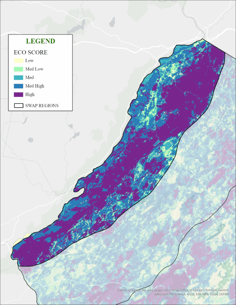
Ecological Priority Model, Spring 2020 – Version 3
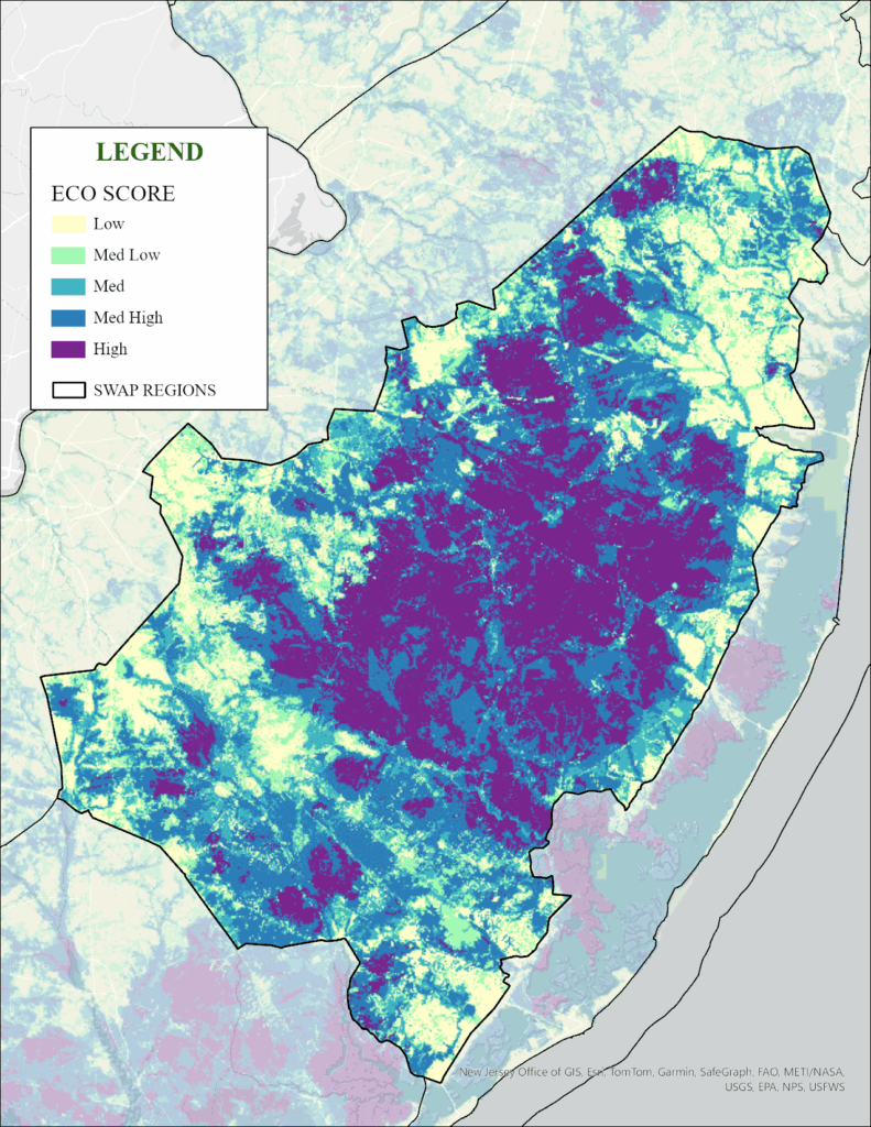
Ecological Priority Model mapping (EcoMap) is a multi-partner effort spearheaded and managed by Rowan University. This map represents lands that are the most ecologically important in New Jersey and includes detailed, publicly available data across four broad ecological indicator categories: water, rare species and natural communities, climate change resilience, and habitat connectivity. The priority layer illustrates lands that are critical to protect to maintain the ecosystems of New Jersey.
Conservation Blueprint Science Advisory Committee. Ecological Priority Model – Version 3.0 (Raster version) also known as Ecosystems to Protect. Published online at https://www.nj-map.com/blueprint/ecological/ , February 2020.
New Jersey’s Landscape Project
New Jersey’s Landscape Project mapping continues to be the principal way NJDEP’s Fish & Wildlife documents habitats that support endangered, threatened, and special concern wildlife species. NJDEP uses the Landscape Project mapping to guide the application of land use regulations that provide protection to imperiled wildlife species’ habitats, for internal review of habitat management plans, and as an important factor in land preservation efforts by the NJDEP’s Green Acres Program. The Landscape Project mapping uses the state’s land use / land cover GIS data and Biotics Database of rare species occurrence data to model species habitat locations in the state. Landscape Project version 3.4 provides this presumptive habitat mapping based on 2020 land use / land cover habitat patches and species occurrence data.
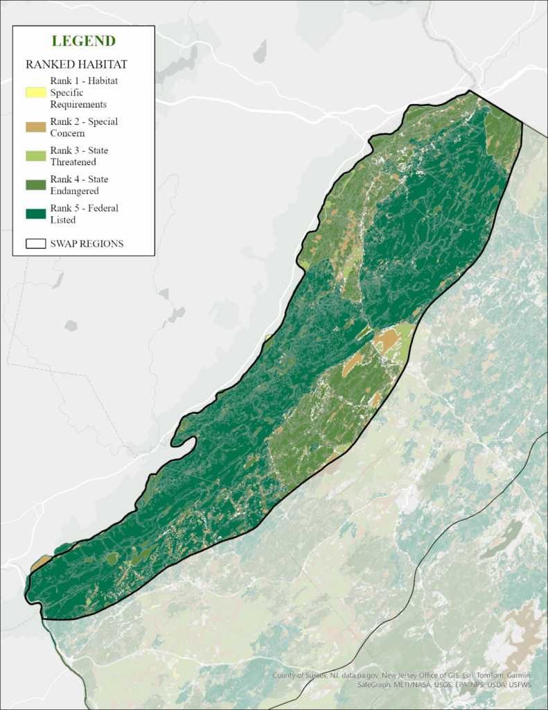
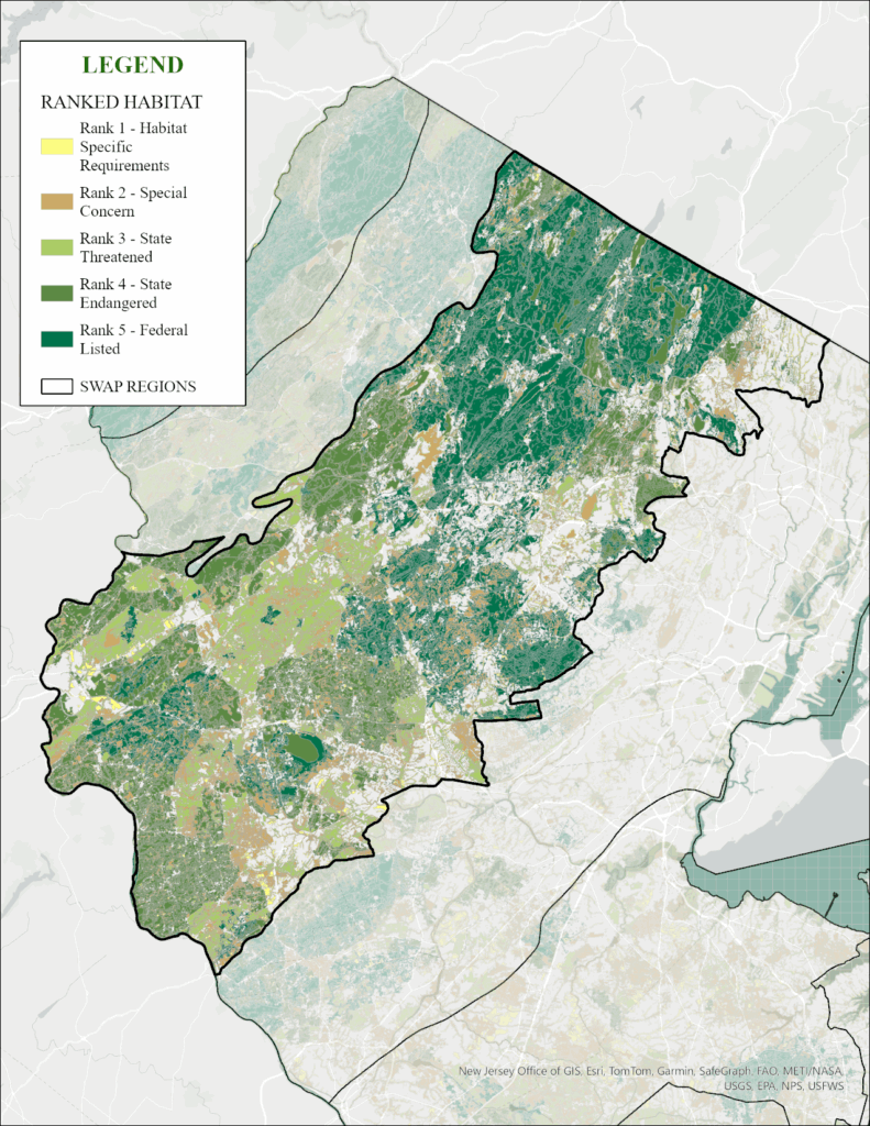
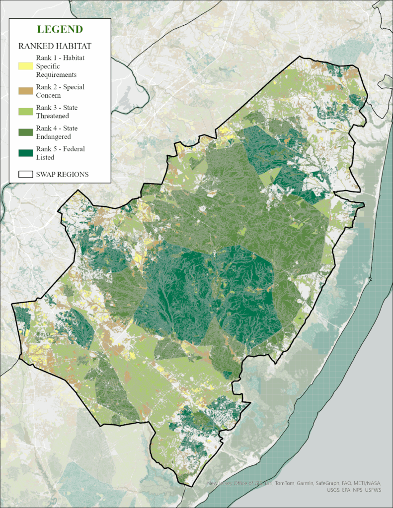
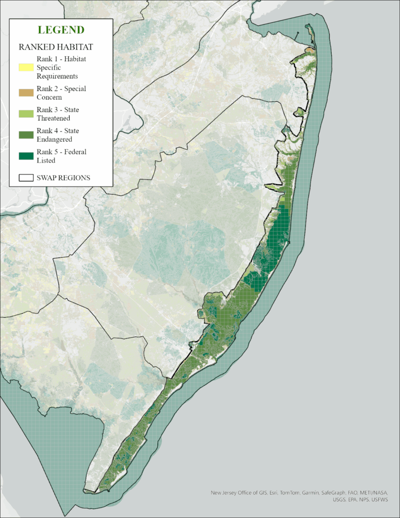
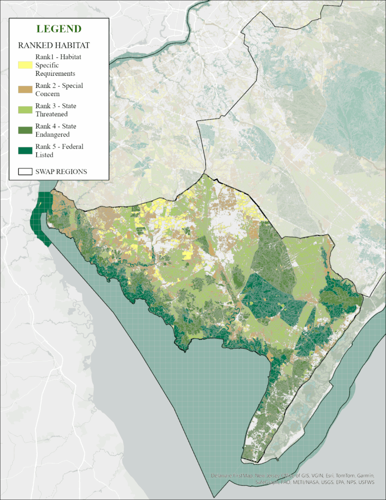
Within each SWAP Region, the Landscape Project mapping depicts the habitats that are ranked based on the combination of habitat type and documented species locations, resulting in habitat patches that are rank 1 (suitable only), 2 (supporting species of Special Concern), 3 (supporting state-threatened species), 4 (supporting state-endangered species), and 5 (supporting federal-listed species). To fully explore the Landscape Project, go to the interactive map HERE .
Connecting Habitat Across New Jersey (CHANJ)
Connecting Habitat Across New Jersey (CHANJ) is a multi-partner, multi-disciplinary strategic plan led by NJ Fish & Wildlife. CHANJ identifies key areas to preserve and restore habitat connectivity for terrestrial wildlife at the local, landscape region, and statewide levels. The CHANJ mapping is designed to help prioritize areas for land protection, habitat restoration and management, and mitigation of road impacts on wildlife and their habitats. CHANJ products include a statewide map of core habitat areas and corridors between them, a guidance document, and a road/wildlife toolkit that provides recommendations on protecting, managing, and restoring the functional connectivity within the core habitat areas and corridors. To explore CHANJ mapping, click HERE .
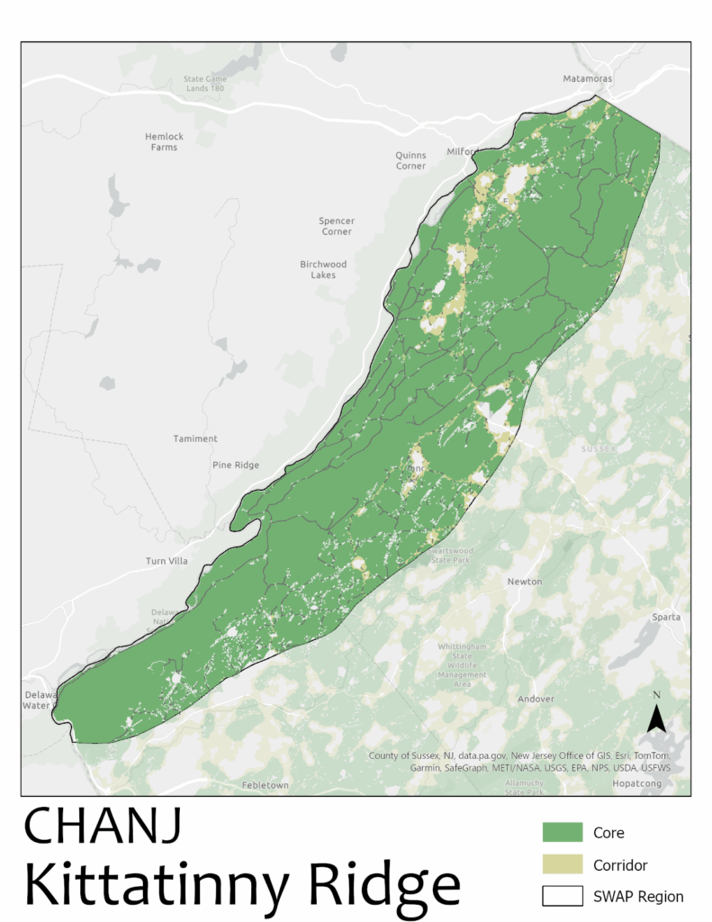
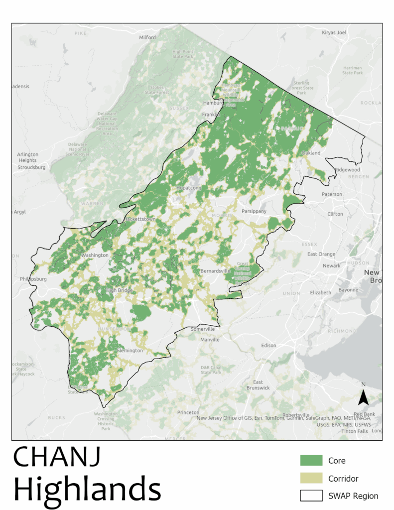
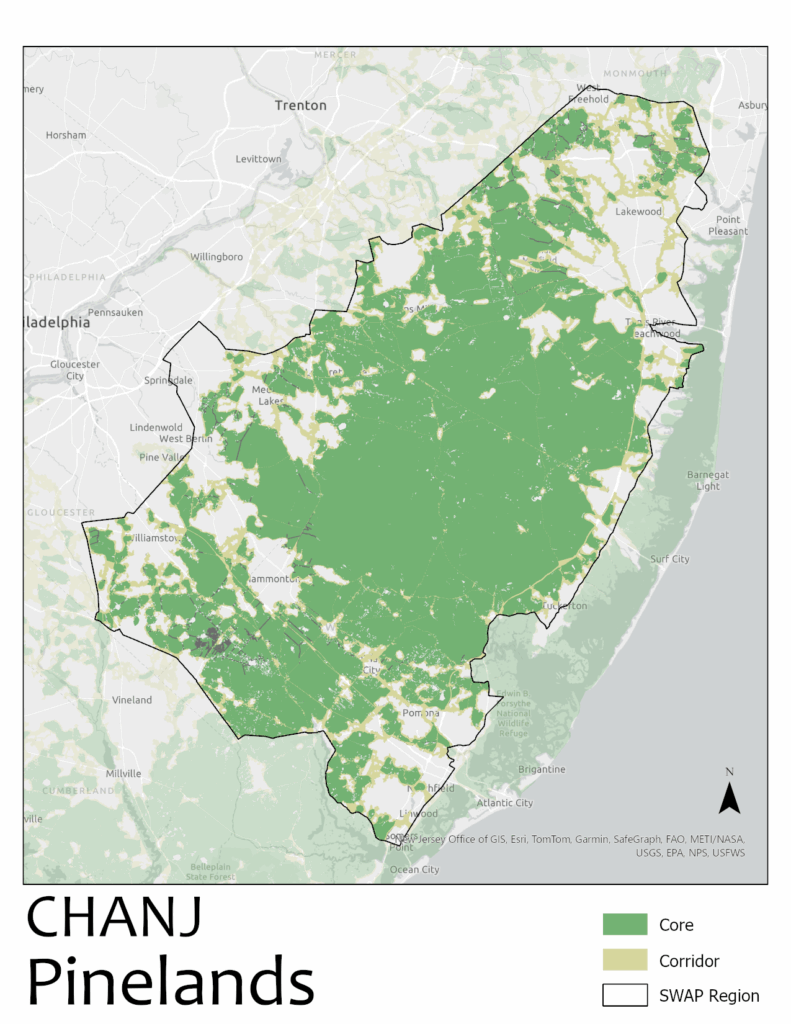
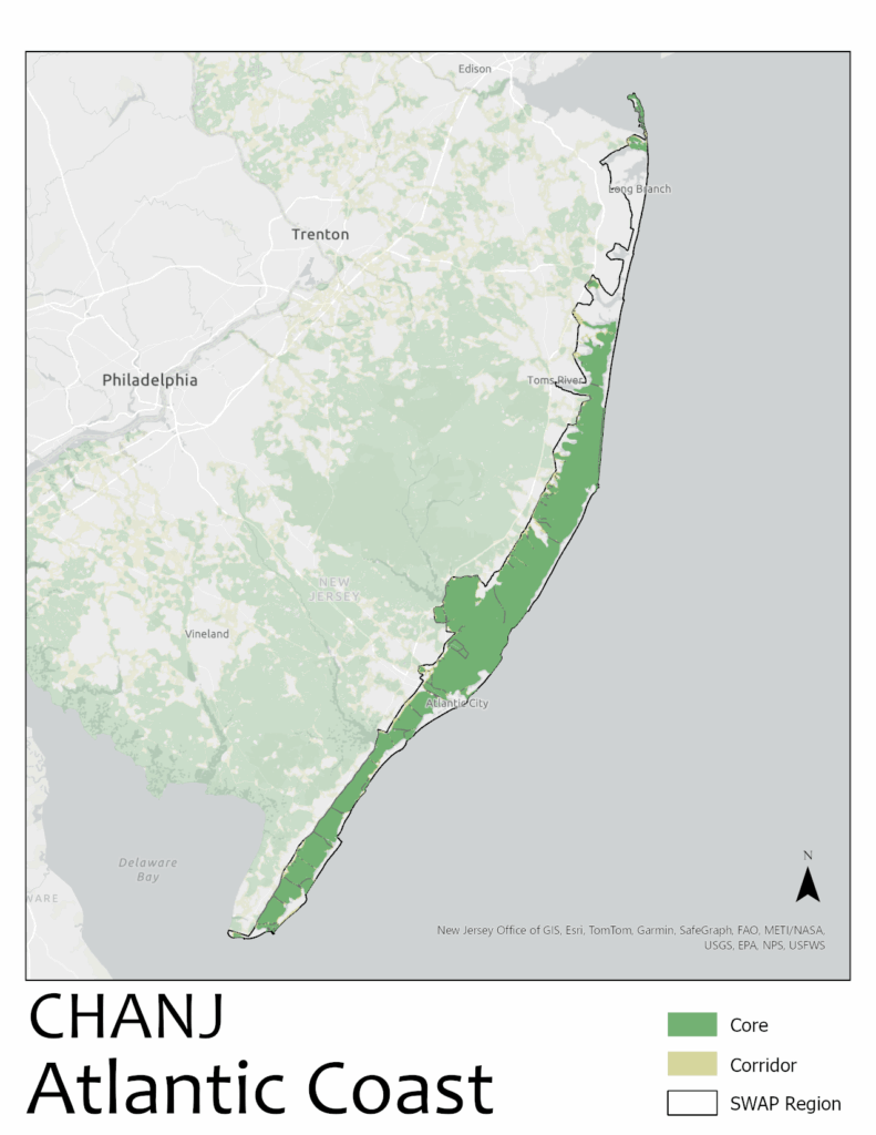
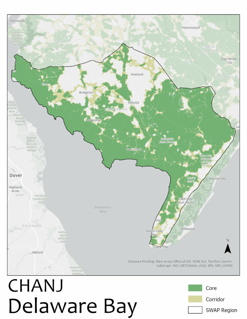
The CHANJ mapping consists of habitat Cores, Corridors, and Road Segments. Cores are patches of contiguous natural land cover of a minimum threshold size, which are likely to meet the habitat needs (shelter, forage/prey, reproduction) of most terrestrial wildlife species, especially if functionally linked to other Cores. Corridors are continuous swaths of habitat representing the most efficient pathways for wildlife to move between Cores. Road Segments are sections of roads within Cores and Corridors, not adjacent to urbanization, and serve as starting points for targeting road/wildlife mitigation efforts.
Additional NJDEP Habitat Mapping Focused on Biodiversity
New Jersey Heritage Priority Sites
A total of 343 Natural Heritage Priority Sites have been identified, representing some of the best remaining habitats for rare species and rare ecological communities in the state. These areas are priorities for the preservation of biological diversity in New Jersey. If these sites become degraded or destroyed, unique components of our natural heritage may be lost. Natural Heritage Priority Site maps are used by individuals and agencies concerned with the protection and management of land. Click HERE to explore the sites.
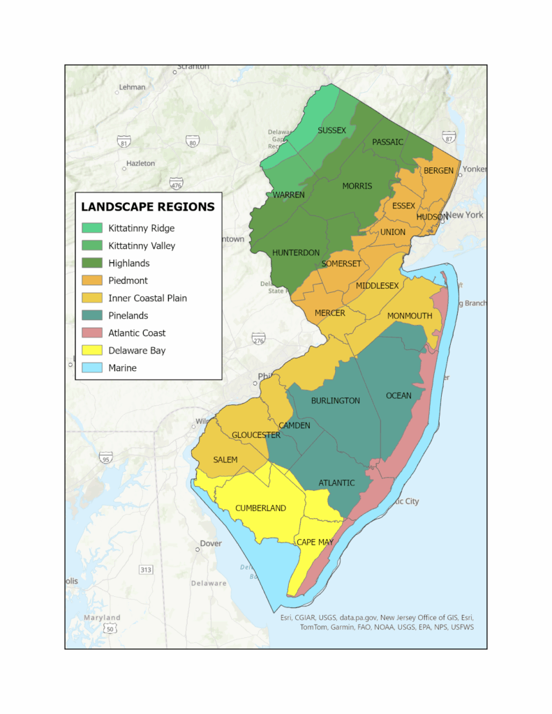
New Jersey’s Nine Landscape Regions for the Wildlife Action Plan
In the 2025 SWAP, New Jersey is divided into nine landscape regions: Kittatinny Ridge, Kittatinny Valley, Highlands, Piedmont, Inner Coastal Plain, Pinelands, Atlantic Coast, Delaware Bay, and Marine (which is exclusively aquatic). The first eight regions are each characterized by landforms, soils, vegetation, and hydrological regimes that collectively support distinctive habitats and plant and animal communities.
Kittatinny Ridge Region
The Kittatinny Ridge Region encompasses portions of Warren and Sussex counties with 37% of its area conserved in state and local open space, but that figure rises to 60% when federally owned lands are included. It features significant topography and ridgeline associated with the Appalachian Mountains and contains a mosaic of habitat types vital to a variety of species including forest (which predominates the region), wetlands, and scrub-shrub habitats, glades, cliffs and rock outcrops, and Category One streams.
While most of this region is in conservation ownership, some forests are threatened by lack of long-term management that has reduced structural diversity; closed canopy conditions and high deer populations that have left the understory barren in many places; and an abundance of invasive, non-native species. Scrub-shrub and other early successional habitats are uncommon due to vegetative succession. The Kittatinny Ridge Region also has significant geologic features, with sandstones and Shawangunk conglomerates on Kittatinny Mountain, and ancient limestone and shale between the mountains and the Delaware River. This geology influences the landscape and geochemistry of rivers and wetlands that support many SGCN.
Ecological Priority Model
The Kittatinny Ridge Region encompasses a variety of habitats of high ecological value, in large part due to the extensive and contiguous tracts of conserved land extending between the northern and southern boundaries of the region. Conserved land is in wildlife management areas, state parks and forests, and national park lands. The lack of major roadways has helped maintain high ecological value in this region, which benefits communities of people, wildlife, and plants. Click HERE .
Landscape Project Map
The Landscape Project mapping uses contiguous habitat patches and is best viewed in the Landscape Project Interactive MAP . This map clips the Landscape Project critical habitat map by the Kittatinny Ridge regional boundary. In Landscape Project map, the SWAP’s Highlands, Kittatinny Valley, and Kittatinny Ridge create the “Skylands” region.
Landscape mapping portrays the importance of this region for endangered, threatened, and special concern wildlife. The extensive tracts of conserved lands provide a stronghold for many listed species, especially non-flying animals, federally listed wildlife, and other imperiled wildlife species including Leonard’s Skipper, Bobcat, Leonard’s Skipper, and plants like Appalachian Twayblade.
CHANJ Map: Connecting Habitat Across New Jersey
CHANJ mapping for the Kittatinny Ridge highlights significant core habitat area in the region. There are also several important corridors that need protection to ensure animals can travel between core areas. Like the Kittatinny Valley region, the Kittatinny Ridge is also part of the broader Appalachian corridor that extends from northern Alabama to the Canadian Maritimes. It is critical that the habitat in this region remains connected to build resilience from the impacts of climate change both within New Jersey as well as the larger Appalachian region. An essential component of habitat connectivity work in the habitat cores and corridors identified by the CHANJ mapping is implementing targeted wildlife passageways through roadways so that wildlife can safely move within and between habitat areas. For an interactive map, CLICK HERE .
Kittatinny Valley Region
The Kittatinny Valley Region is part of the Ridge and Valley Physiographic Province and includes a small portion of the Highlands Physiographic Province. It encompasses portions of Warren and Sussex Counties. Approximately 32% and 7% of this region lies within the Highlands Planning Area and the Preservation Area, respectively, with land use planning administered by the Highlands Council.
The Kittatinny Valley is characterized by unique geologic formations and large remnants of glacial lakes that support extensive wetlands. The “sweet” alkaline soils in this broad valley support agriculture and grasslands among rolling forested hillsides and distinctive groundwater-fed wetland complexes, creating a mosaic of habitats ranging from small forest tracts to riparian habitats, scrub-shrub habitats, grasslands, and Category One streams woven among sprawling residential communities and town centers. This region is a hotspot for biodiversity with unique habitats that support numerous at-risk species. It provides breeding habitat for NJ’s endangered Golden-winged Warblers and the Northern Metalmark.
Natural habitats are threatened by the lack of long-term management, invasive species control, sprawling development and infrastructure. The presence of active and inactive agricultural lands that are unsuitable for wildlife reduces connectivity within this region and between neighboring regions. Traditional agricultural practices can degrade habitats and threaten wildlife by contributing sediment, phosphorus, and fecal coliform to waterways.
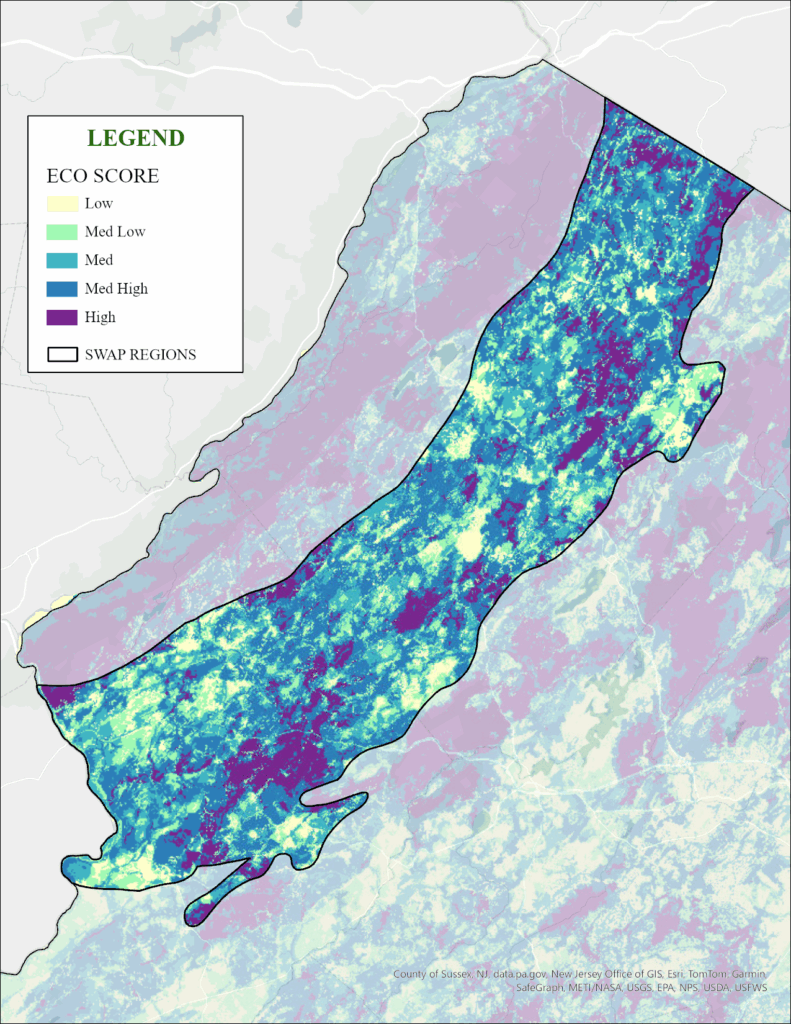
Ecological Priority Model
The Ecological Priority Map of the Kittatinny Valley Region reflects a matrix of high and medium value ecological patches throughout. This region provides important opportunities for habitat connectivity within and between regions, a critical factor in increasing resilience in a changing landscape. Click HERE
to explore.
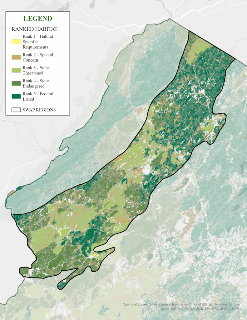
Landscape Project Map
The Landscape Project mapping uses contiguous habitat patches and is best viewed in the Landscape Project Interactive MAP .
This map clips the Landscape Project critical habitat map by the Kittatinny Valley regional boundary. In the Landscape Project map, the SWAP’s Highlands, Kittatinny Valley, and Kittatinny Ridge create the “Skylands” region.
Landscape mapping portrays the importance of this region for endangered, threatened, and special concern wildlife. The northern half of this region has documented habitats for federal and state-listed wildlife, including bat species (Indiana Myotis, Northern Myotis, Little Brown Myotis), bird species (Red-headed Woodpecker, Golden-winged Warbler, Bobolink), Bobcat, Bog and Wood turtles, Bronze Copper, and more.
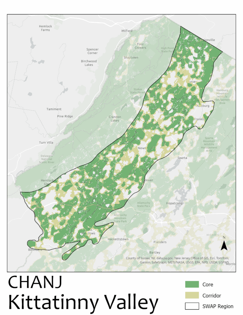
CHANJ Map: Connecting Habitat Across New Jersey
CHANJ mapping for the Kittatinny Valley highlights significant core habitat areas in the region that are so important to long term population viability for terrestrial wildlife. CHANJ modeling also identifies important corridors that need protection to ensure animals can travel between core areas and across the larger landscape. This region is part of a broader Appalachian corridor that extends from northern Alabama to the Canadian Maritimes. It is critical that the habitat in this region remains connected to build resilience from the impacts of climate change both within New Jersey and the larger Appalachian region. An essential component of habitat connectivity work in the habitat cores and corridors identified by the CHANJ mapping is implementing targeted wildlife passageways through roadways so that wildlife can safely move within and between habitat areas. For an interactive map, click HERE .
Highlands Region
The Highlands Region is part of the Highlands and Piedmont physiographic provinces and includes a small portion of the Ridge and Valley physiographic provinces. It encompasses parts of Bergen, Passaic, Morris, Sussex, Hunterdon, Somerset, and Warren counties, and a small portion of Essex County. About 38% and 41% of this region lies within the Highlands Planning Area and Highlands Preservation Area, respectively (NJDEP| Watershed & Land Management | Highlands ). The beautiful, rugged terrain of the Highlands, part of the Appalachian Mountains, is formed by its complex geologic history with ancient bedrock (granite, gneiss) and numerous parallel mountains with deeply carved valleys formed by rivers. It supports a mosaic of habitat types vital to species that rely on forest, wetland, riparian, and scrub-shrub habitats, glades, cliffs and rock outcrops, and Category One streams woven among residential communities and agricultural lands.
The conditions of the region’s habitats vary significantly. Although conserved lands can be found throughout the region, the northerly portion has larger, contiguous tracts of conserved (or otherwise protected) land where extensive tracts of high quality, interior forest habitat support area-sensitive species. Other areas have interspersed conserved lands among suburban, agriculture, and undeveloped private lands. Forests in the region are threatened by the lack of long-term management, invasive species, and high deer populations that have left the understory barren in many places. Scrub-shrub habitat is uncommon due to vegetative succession and remaining patches are vulnerable to development. Traditional agricultural practices can degrade habitats and threaten wildlife by contributing sediment, phosphorus, and fecal coliform to waterways.
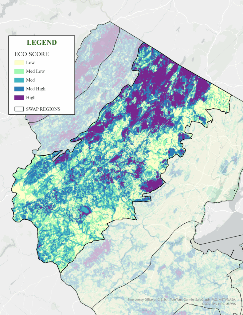
Ecological Priority Model
The Highlands Region includes a variety of habitat types in this transition area between mountains and the plain to the south. Habitats with high ecological scores are concentrated in the northern one-third, on lands in conservation ownership as state parks and wildlife management areas, and by water authorities that protect land around drinking water reservoirs. Good value habitats are found throughout this region, with more farmland and Delaware River tributaries making up the more western portion. Fragmentation by development is evident in the Highlands Region, demonstrating the importance of preserving and/or creating habitat connections. Click HERE to explore.
Landscape Project Map
The Landscape Project mapping uses contiguous habitat patches and is best viewed in the Landscape Project Interactive MAP . This map clips the Landscape Project critical habitat map by the Highlands regional boundary. In Landscape Project map, the SWAP’s Highlands, Kittatinny Valley, and Kittatinny Ridge create the “Skylands” region.
The Landscape Project map helps highlight locations of endangered, threatened, and special concern wildlife populations. For the Highlands, habitats important to these species include forests, woodlands, and various aquatic habitats throughout this region, and open grassland habitats toward the west. Some of the largest freshwater lakes are found here, and the Delaware River tributaries are especially important for aquatic species like Brook Trout and other fish, freshwater mussels, dragonflies, and freshwater turtles. Many of the Highlands’ rank 5 habitats are valued by imperiled bat species, that hibernate in various caves and former mines found across this region and spend the warm months roosting and foraging throughout its forests and floodplains.
CHANJ Map: Connecting Habitat Across New Jersey
CHANJ mapping for the Highlands shows the transition from larger, more connected core habitats in the northern part of the region to the smaller, sparser, tenuously linked habitats at the southern end. Corridors need protection to ensure animals can travel between the remaining core areas and to preserve functional connectivity between the Kittatinny Valley and Piedmont regions. It is vital in this region to grow and protect core habitat areas as well as secure the identified corridor habitats between them before the connections are lost to development. An essential component of habitat connectivity work in the habitat cores and corridors identified by the CHANJ mapping is building targeted wildlife passageways through roadways so that wildlife can safely move within and between habitat areas. For an interactive map, CLICK HERE .
Piedmont Region
The Piedmont Region incorporates most of the Piedmont Physiographic Province that encompasses all or parts of Bergen, Passaic, Essex, Hudson, Morris, Union, Somerset, Middlesex, Hunterdon, and Mercer counties. Also known as “foothills” or Piedmont Lowlands, the Piedmont is a low rolling plain divided by a series of higher ridges at the base of the Appalachian Mountain range with elevations from 300 feet to just over 900 feet above sea level. The geology of the Piedmont is soft shales and sandstones of Triassic age, with intrusions of volcanic diabase sills (the Palisades) and lava flow basalts (the Watchung Mountains). The historic, glacial “Lake Passaic” that formed in the basin between ridges supports massive wetlands today, including Troy Meadows and the Great Swamp.
The conditions of the region’s habitats vary, but all have been influenced by human settlement as most of this region has been logged, farmed, or developed. The northern part of the Piedmont (parts of Bergen, Passaic, Essex, Hudson, and Union counties) is mostly developed with scattered habitat oases consisting of woodlands, shrublands and grasslands, lakes and streams, and tidal marshes. This northern part includes the Meadowlands – a vast tidal marshland that is important habitat and an oasis amid the most urbanized part of New Jersey. The southern Piedmont (parts of Hunterdon, Mercer, Somerset, Middlesex, Morris, and western Union counties) is a mixture of developed areas with fragmented woodlands, grasslands and agriculture, and shrublands.
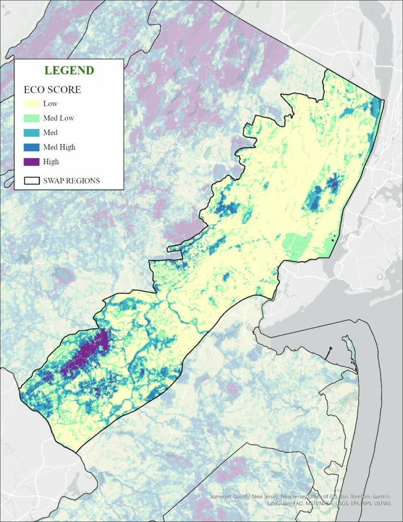
Ecological Priority Model
The Piedmont Region has some of the lower ecological scores, largely due to the high degree of urbanization in the northeastern part of the state and the highway corridor spanning the region between Philadelphia and New York City. In its northern end, the Meadowlands marshes, the Palisades Interstate Park forests, and the Watchung Mountains are incredibly valuable habitats. In its southern end, the habitats of the Sourland Mountains rank high for ecological values. This is a region where targeted conservation action is necessary to address current and future threats of habitat loss, species population declines, and, especially, a potential loss of connectivity between conserved habitats in northern and southern New Jersey. Click HERE to explore.
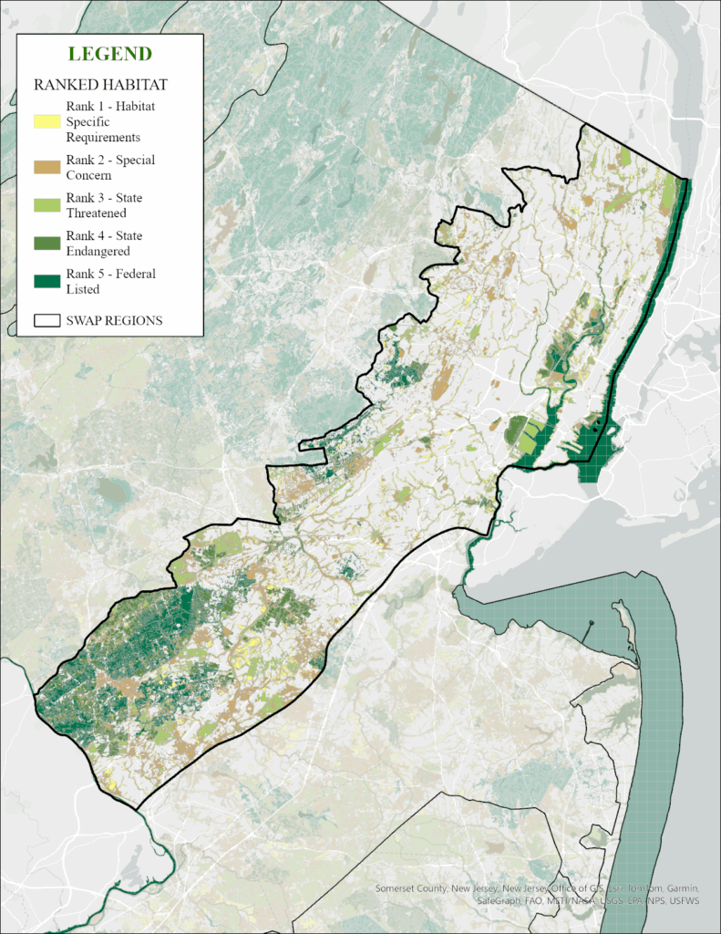
Landscape Project Map
The Landscape Project mapping uses contiguous habitat patches and is best viewed in the Landscape Project Interactive MAP . This map clips the Landscape Project critical habitat map by the Piedmont regional boundary.
The Landscape Project map helps highlight locations of endangered, threatened, and special concern wildlife populations. For the Piedmont, those are forests, woodlands, and freshwater marshes that support nesting and migrating birds, as well as some unique populations of reptiles and amphibians. Many habitats here have been fragmented by development and roads, making it essential to improve the condition of remaining habitats for resident and migratory wildlife to ensure security of local populations.
CHANJ Map: Connecting Habitat Across New Jersey
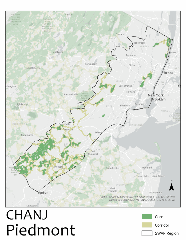
CHANJ mapping for the Piedmont highlights the sparse availability of core habitat areas in the region. However, it is a crucial region for maintaining – and improving – habitat connections between habitats. More broadly, this region is essential for maintaining gene flow of terrestrial wildlife populations between the northern and southern regions of the state. The dense highway system between Philadelphia and New York City is especially challenging for wildlife to navigate. Targeted safe wildlife passage systems are critically needed. The CHANJ project identifies habitat corridors that are in dire need of conservation action for New Jersey wildlife and their ability to move across the landscape. The thin corridors in this region must be secured before they are lost to development. For an interactive map, CLICK HERE .
Inner Coastal Plain Region
The Inner Coastal Plain encompasses all or parts of Middlesex, Mercer, Monmouth, Burlington, Camden, Gloucester, Salem, and Cumberland counties. The geology of the Inner Coastal Plain is primarily clays, silts, and sands, with some ironstone ridges. The relict coastal hardwood forests are diverse, and large wetlands complexes such as those in Assunpink WMA are important refugia for wildlife and plants. The southern part of this region supports an abundance of vernal pools and vegetated intermittent ponds. The many freshwater and brackish tidal tributaries to the Delaware River provide significant stream and riparian habitat. Habitats are characterized by agricultural lands, extensive grasslands, fragmented woodlands, and biologically productive tidal freshwater marshes.
The conditions of the region’s habitats vary, but all have been influenced by human settlement as most of this region has been logged, farmed, or developed. Threats today and in the future include invasive species, continued development, and over-browsing by white-tailed deer. Sea level rise impacts the freshwater tidal marshes as the saltwater line moves farther up into the Delaware and Raritan rivers and their tributaries.
Ecological Priority Model
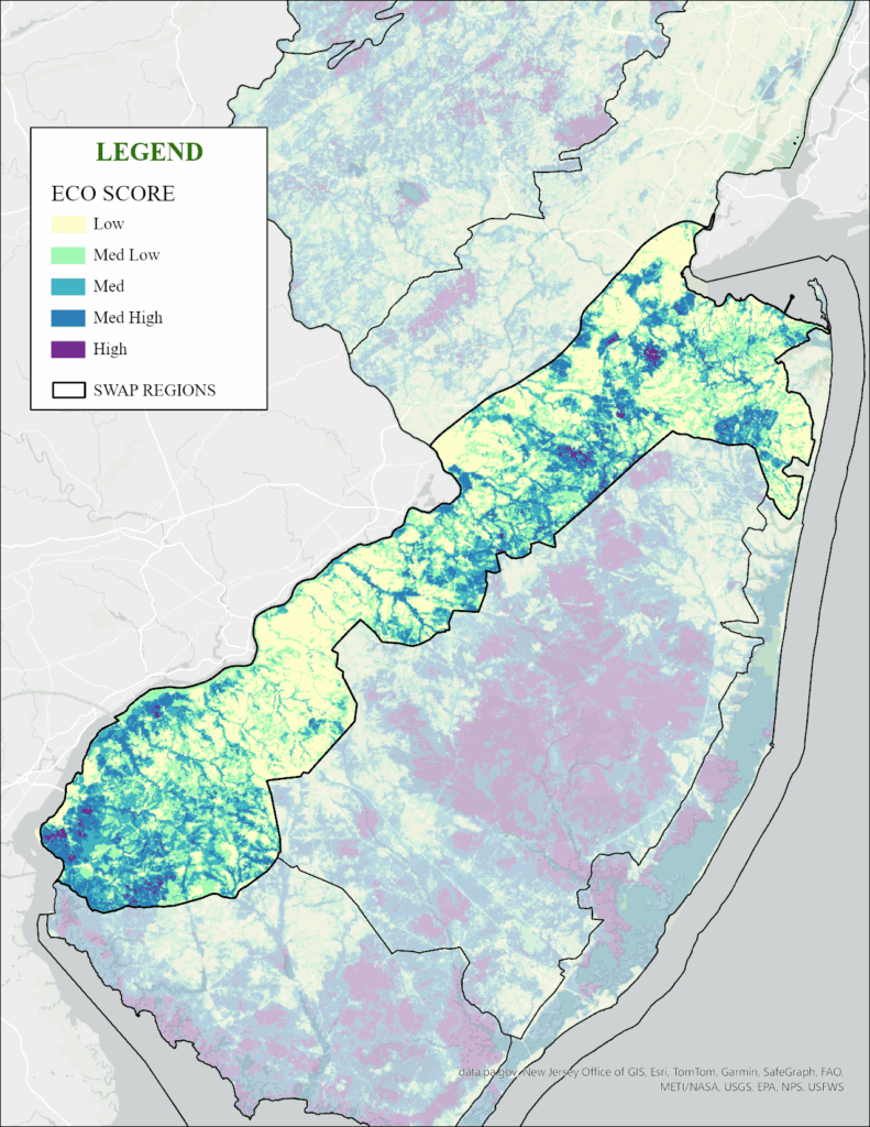
The Inner Coastal Plain Region contains many areas that are ranked low to medium by the Ecological Priority Map. This is largely due to the high degree of habitat fragmentation caused by development and road density. The habitats that remain in this region are extremely important for the species that occur here. From open uplands and woodlands to the abundant freshwater and saline tidal streams and wetlands, these habitats support populations of a great diversity of plants and animals. The Inner Coastal Plain ranks lowest of the nine regions in the percentage of conserved open space, but it ranks highest for the number of potential vernal pools, a habitat critical for many at-risk amphibians. Click HERE to explore.
Landscape Project Map
The Landscape Project mapping uses contiguous habitat patches and is best viewed in the Landscape Project Interactive MAP . This map clips the Landscape Project critical habitat map by the Inner Coastal Plain regional boundary.
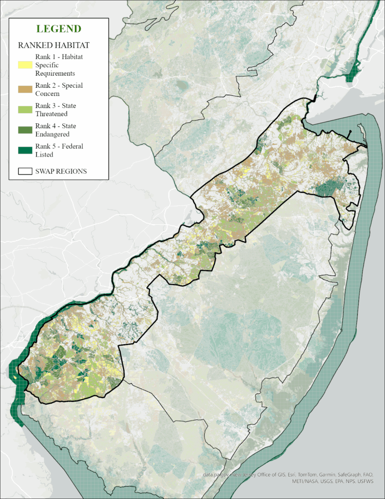
The Landscape Project map highlights the locations of endangered, threatened, and special concern wildlife populations. In this region, there are relatively few habitat patches valued for endangered wildlife, but there are some notable clusters where conservation actions are important to address threats related to fragmentation and to ensure the remaining habitats are productive and resilient.
CHANJ Map: Connecting Habitat Across New Jersey
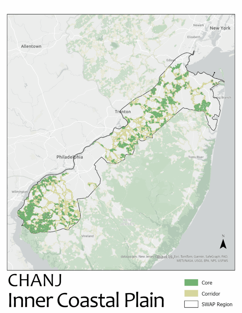
CHANJ mapping for the Inner Coastal Plain reflects the lack of large core habitat patches in the region. However, this region is crucial to connecting habitats between the northern and southern parts of the state. CHANJ mapping identifies the remaining habitat corridors that are most important to preserve and restore for the long-term viability of wildlife populations both within the region and across the state. An essential component of habitat connectivity work in the habitat cores and corridors identified by the CHANJ mapping is implementing targeted wildlife passageways through roadways allowing wildlife to safely move within and between habitat areas. In addition, the riparian corridors are important for aquatic connectivity across this region and adjacent regions. For an interactive map, CLICK HERE .
Pinelands Region
The Pinelands region encompasses all or parts of Atlantic, Ocean, Burlington, Camden, and Gloucester counties. The geology of the Pinelands on the coastal plain is rooted in the last ice age that caused sand deposition and erosion plus freeze-thaw cycles. Patterns in the landscape now are driven by fires in the extensive dry, sandy forests and by water in the many rivers and riparian swamps fed by the deep and massive Kirkwood-Cohansey Aquifer.
New Jersey’s Pinelands (or Pine Barrens) is an internationally recognized ecosystem consisting predominantly of pine and pine-oak mesic upland forests, pitch pine lowlands, and cedar swamps supporting diverse reptile, amphibian, and invertebrate populations (including interior forest and area-sensitive species), and unique ecological communities. Extensive cedar swamps and wetland systems are home to numerous insect species and populations of many neotropical birds. Its waterways support aquatic communities unique among the mid-Atlantic states and its aquifers provide drinking water to a large portion of the surrounding region.
The Pinelands has important and specific regulations and land protections, however habitats remain at risk. The region’s low diversity of forest types makes it more susceptible to impacts from climate change, such as the region-wide invasion of the southern pine beetle. The Pine Barrens is a pine-dominated forest, fire-adapted system where the forest structure was historically maintained by wildfires. More recently, that structure was maintained by human activities such as logging and charcoal production. Today, changes in wildfire patterns are converting the forest to a closed canopy condition and the tree species composition is changing to include more deciduous hardwood trees. Addressing long term threats like climate change and invasive species, plus managing habitats in a fire-adapted ecosystem, are among the challenges ahead.
Ecological Priority Model
Overall, the condition of the Pinelands Region’s habitats is ranked very high, with vast forest and wetlands ecosystems preserved and intact, thanks to abundant state park and forest holdings and to the federal designation of the more than one million-acre Pinelands National Reserve . This designation carries strong stewardship and regulatory protections that are enforced by the New Jersey Pinelands Commission . This level of protection has allowed a wide diversity of wildlife and plants to thrive in this unique ecosystem. Click HERE
to explore.
Landscape Project Map
The Landscape Project mapping uses contiguous habitat patches and is best viewed in the Landscape Project Interactive MAP . This map clips the Landscape Project critical habitat map by the Pinelands regional boundary.
The Landscape Project map helps highlight locations of endangered, threatened, and special concern wildlife populations. For the Pinelands, those include forest species, aquatic species adapted to the somewhat acidic streams, ponds, and wetlands, and unique plant communities adapted to its sandy soils. The large, unfragmented forests are important for migrating landbirds, the Georgia (Helicta) Satyr, and Pinelands-specific reptile and amphibian species like the Pine Barrens Treefrog and Northern Pinesnake. Rare plants like Chapman’s Yellow-eyed-grass thrive in the Pinelands as well as unique plant communities including pygmy pine forests, Atlantic white cedar swamps, and wetland meadows.
CHANJ Map: Connecting Habitat Across New Jersey
CHANJ mapping for the Pinelands highlights the significant core habitat area found nowhere else in the state, thanks to the lower density of roads and development in this region. There are, however, important corridors to protect to ensure wildlife can travel between habitats in search of food, shelter, and mates. An essential component of habitat connectivity work in the habitat cores and corridors identified by the CHANJ mapping is implementing targeted wildlife passageways through roadways allowing wildlife to safely move within and between habitat areas. Considering the number of wildlife and plant species that are unique to the Pinelands, maintaining connections to ensure their long-term population viability is an important goal. For an interactive map, CLICK HERE .
Atlantic Coast Region
The Atlantic Coast region encompasses parts of Monmouth, Ocean, Atlantic, and Cape May counties. The underlying geology of the outer coastal plain on the Atlantic Coast driving habitat diversity is primarily the sands overlain by marsh peat deposits formed since the last glaciation. Changes in sea level are changing the geomorphology of coastal features and causing a landward migration of coastal marsh habitat. Habitats include barrier islands and beaches, tidal salt marshes, rivers, shallow bays, and lagoons along New Jersey’s coastline.
New Jersey’s Atlantic Coast beaches and marshes are among the most productive coastal habitats in the country. This region is the primary habitat for New Jersey’s coastal-nesting bird communities that depend on fish, shellfish, and marine invertebrates for food, and the salt marsh matrix habitat of mudflat, low marsh, high marsh and tree-shrub patches. This region plays a crucial part of the Atlantic flyway for migration of songbirds, raptors, and waterfowl. The region also includes urban centers with limited remaining natural areas.
Ecological Priority Model
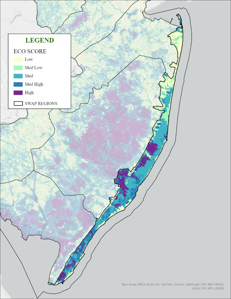
The Ecological Priority map for the Atlantic Coast region highlights a disparity of high-value, critical wildlife habitat adjacent to highly developed Jersey shore towns. Areas of saltmarshes and open water back-bays are shown in darker colors as high ecological value, while areas in lighter colors show where habitat value has been compromised by development. The extent of coastal and shoreline development has led to impediments to natural beach and dune processes, and a system of sand replenishment to maintain beaches for human uses. Click HERE
to explore.
Landscape Project Map
The Landscape Project mapping uses contiguous habitat patches and is best viewed in the Landscape Project interactive MAP . This map clips the Landscape Project critical habitat map by the Atlantic Coast regional boundary.
The Landscape Project map helps highlight locations of endangered, threatened, and special concern wildlife populations. For this region, those are primarily composed of colonial-nesting birds like herons, egrets, gulls, and terns that nest in the coastal saltmarshes, as well as Ospreys and Bald Eagles. This region is critical for the beach- and marsh-nesting species like Northeastern Beach Tiger Beetles, Piping Plovers, Black Skimmers, American Oystercatchers, Black Rails, and Diamond-backed Terrapins. And plants like Sea-beach Knotweed.
CHANJ Map: Connecting Habitat Across New Jersey
CHANJ mapping for the Atlantic Coast portrays significant core areas, but many of those include open waters of the back bays that are contiguous with tidal saltmarshes. In addition, there are important corridors that need permanent protection to ensure animals can travel between habitats and into adjacent regions. In this region, improving the connectedness of habitats is important for coastal wildlife like saltmarsh birds, Northern Diamond-backed Terrapins, and the vast number of migrating birds in spring and fall that rely on contiguous or connected habitats without impediments like roads and buildings that can impact survival. Habitat connectivity for the Atlantic Coast region must also consider marsh migration which is the ability of the saltmarsh to move inland in response to sea level rise, and marsh subsidence. For an interactive map of CHANJ critical habitats, CLICK HERE .
Delaware Bay Region
The Delaware Bay region encompasses all, or parts of, Cape May, Atlantic, and Cumberland counties. This southern portion of the coastal plain is underlain by layers of gravel, sand and silt, and supports the Kirkwood-Cohansey water aquifer. Tidally influenced rivers and wetlands occur in the Delaware River/Bay tributaries, while inland there is an abundance of vernal pools and intermittent ponds. The region still contains vast woodland tracts that are among the largest in the state, with large acreages in conservation ownership, enhancing their value to migratory and nesting neotropical birds and raptors. Beyond the forests, the region’s expansive habitat mosaic of streams and tidal rivers flowing into Delaware Bay supports concentrations of rare wildlife and plants, including wintering waterfowl.
Extensive saltmarsh and sandy beaches support the largest concentration of spawning horseshoe crabs in the world, critical to hundreds of thousands of migrating shorebirds, including the Red Knot, a federally threatened species. The Cape May peninsula remains one of the country’s most important migratory stopovers for hundreds of bird and insect species like the Monarch Butterfly. The peninsula is also a hotspot for botanical diversity, supporting many rare species at the northern edge of their range.
Ecological Priority Model
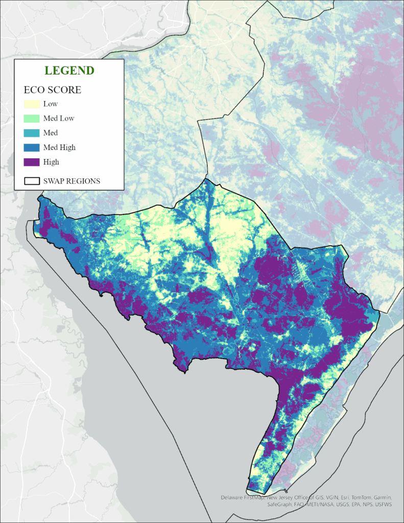
The Ecological Priority map for the Delaware Bay region portrays some of the vast areas of the highest-value habitats in New Jersey. Many of these lands support tidal and freshwater wetlands that support rare wildlife and plant species. The relatively high acreage of land in conservation ownership has contributed to the importance of this region for wildlife and plants – places that remain wild. While these areas score high in ecological value, there are parts of this region where conservation actions are warranted to preserve species that use a variety of habitats, and where long-term habitat connections should be preserved. Click HERE to explore.
Landscape Project Map
The Landscape Project mapping uses contiguous habitat patches and is best viewed in the Landscape Project Interactive MAP . This map clips the Landscape Project critical habitat map by the Delaware Bay regional boundary.
The Landscape Project map helps highlight locations of endangered, threatened, and special concern wildlife populations. For this region, those are the saltmarsh and beach species including migrating and nesting birds, and forest-interior songbirds and raptors. The Cape May peninsula habitats are critical for migrating landbirds as well as wetland-dependent amphibians. This region is known for many species associated with waterways – Bald Eagles, Ospreys, Northern Harriers, and Diamond-backed Terrapins.
CHANJ Map: Connecting Habitat Across New Jersey
CHANJ mapping for the Delaware Bay highlights the significant area of unfragmented core habitat plus critical corridors that need to be protected for long term viability of wildlife populations. Protecting these corridors helps ensure animals can travel between habitats. Securing the corridors of habitat that connect larger cores enhances the value of existing conserved lands and is insurance against isolating wildlife populations that become vulnerable to other threats. Securing corridors is of particular importance in the Cape May peninsula where water limits wildlife movement and in inland areas fragmented by development. An essential component of habitat connectivity work in habitat cores and corridors is building wildlife passageways through roadways allowing wildlife to safely move within and between habitat areas. For an interactive map, CLICK HERE .
Marine Region
The Marine Region is entirely open water and spans from the mouth of the Raritan River, around Sandy Hook, and the area of State waters along the Atlantic coast and all of Delaware Bay open waters. State waters is defined as three miles from the Atlantic shore, beyond which is federal waters. Habitats in this region are defined as “nearshore,” from mean low waterline seaward beyond the breaker zone, and “offshore,” extending seaward from the marine nearshore into the deep waters of the Atlantic Ocean. These open waters support an immense ecosystem that is largely out of view and includes marine fish, shellfish, marine invertebrates, marine turtles, and marine mammals. Offshore, the Gulf Stream and cold-water currents create dynamic temperature shifts that influence marine life migrations. New Jersey’s network of artificial reef sites is located in this habitat. This habitat supports species from plankton to Humpback Whales.
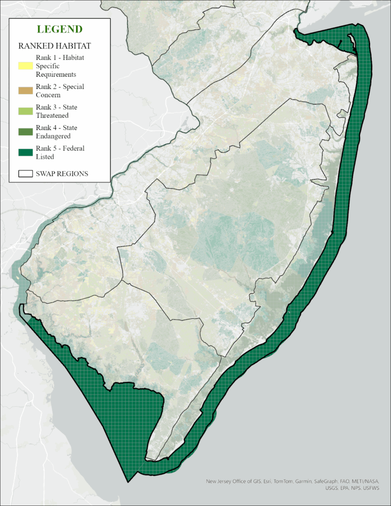
The Marine Region is not mapped in the same ways the other regions are portrayed; however, the Landscape Project map uses species occurrences to identify general areas where endangered, threatened, and special concern wildlife have been documented.
Landscape Project Map
The Landscape Project mapping uses contiguous habitat patches and is best viewed in the Landscape Project Interactive MAP .
The Landscape Project map of the Marine Region uses a grid to define water areas that are ranked based on documented species occurrences. Nearly the entire region is “rank 5” because these waters support federally listed marine mammals, marine turtles, and fish.
Mapping and Habitat Condition Changes from 2017 to 2025
In the 2017 SWAP, New Jersey created Conservation Focal Areas (CFAs) to identify areas where taking conservation action would be most effective. During our 2025 comprehensive update, we determined that the methodology used to produce the 2017 CFAs was not easily repeatable or updateable.
In the 2025 SWAP, we are using three separate mapping tools to better identify priority habitats within each region. Those mapping tools are the “Ecological Priority Model” map, Landscape Project critical habitat map, and the CHANJ project map. Individually, each map depicts a different story of habitat conditions. Together, the maps help identify the overall condition of areas in each region that combined highlights the locations conservation actions are best taken to address the priority threats facing the region. These map products are updated on a regular basis using standardized, repeatable metrics, which will help track both positive and negative changes over time.
The Ecological Priority Model prioritizes areas based on four broad ecological indicator categories: water, natural communities (including NJ Landscape Project layers), climate change resilience, and habitat connectivity.
The NJ Landscape Project map uses species occurrence data with species habitat suitability to create layers of species-based patches; it is the DEP’s map of critical wildlife habitat for New Jersey.
CHANJ mapping identifies areas of core habitat and the connections necessary to preserve connectivity.
