Higbee Beach Wildlife Management Area Restoration Project
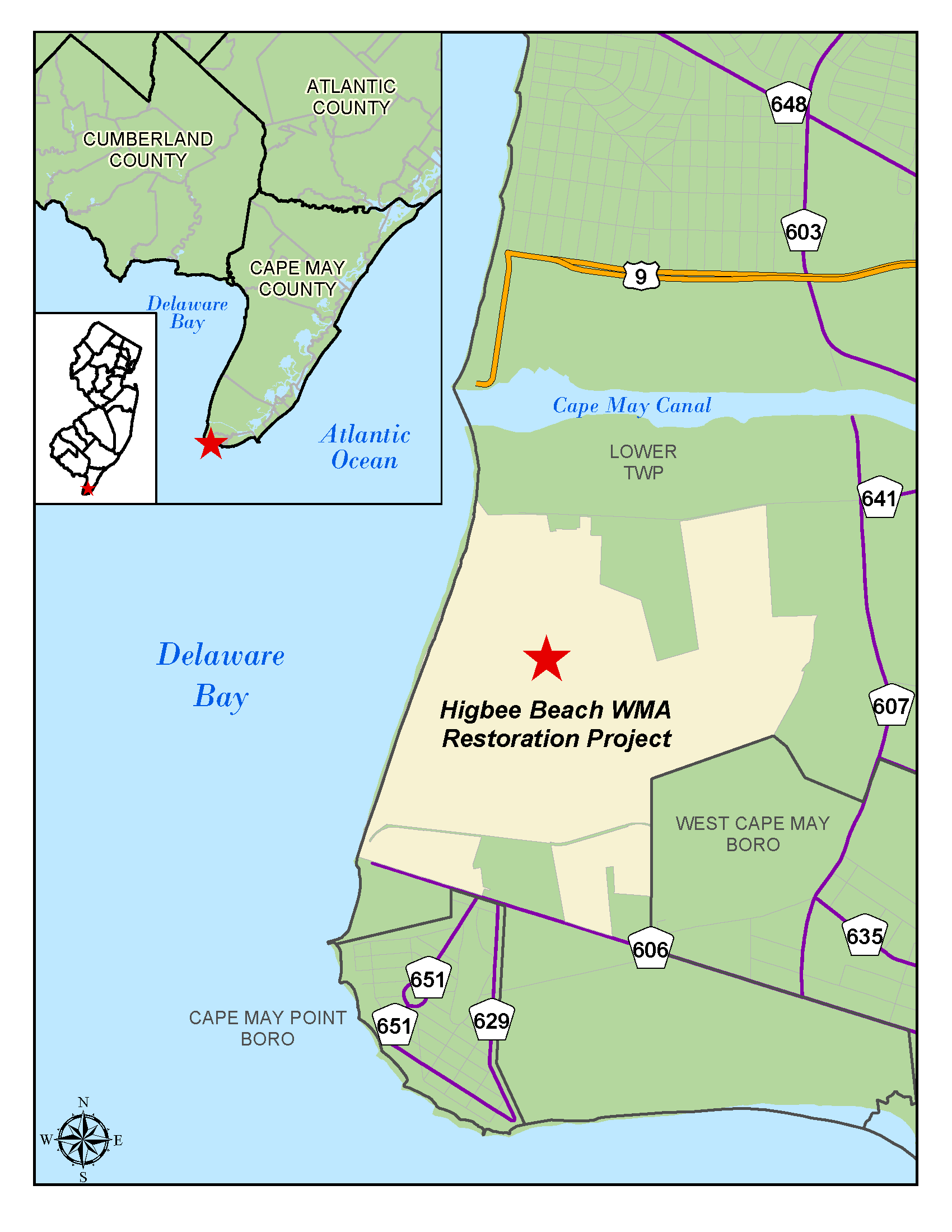
LOCATION: Higbee Beach Wildlife Management Area (WMA), Lower Township, Cape May County
PURPOSE: The purpose of this project is to restore tidal hydrology and function to Pond Creek marsh, restore upland areas of the WMA which were degraded by the manufacturing operations from the former Harbison Walker Magnesite facility in order to create and enhance habitat for migratory birds, fish and various threatened and endangered (T&E) species, and to enhance public access.
PROJECT UPDATES: Project construction commenced in mid-February 2024 with site preparation, including vegetation clearing, installation of soil erosion sediment control measures, and the construction of a ditch plug to temporarily disconnect tidal flow into Pond Creek. By June 2024, the eastern and northern berm foundations were completed.
The excavation of approximately 3,561 linear feet of the mainstem of Pond Creek was completed in November 2024. As of March 2025, approximately 8,500 linear feet out of a total of 14,220 linear feet of interior tributaries have been excavated. These excavations generated over 75,170 cubic yards of material for reuse elsewhere throughout the project site to date. Excavation and contouring of the remaining interior channels, mudflats, and ponds will continue through 2025.
The construction of 3 out of 6 sand/shell habitat islands planned for the project were completed in January 2025. These islands within open areas of marsh will provide nesting and foraging habitat for migratory birds. Construction of the remaining sand/shell habitat islands will continue through the remainder of construction. Numerous dune systems, located along the bayside have been constructed and some have been vegetated with beachgrass plugs (Ammophilia breviligulata) and seeded with panic grass (Panicum amarum). The bayside dunes are expected to be fully constructed and planted by the end of spring 2025. The first project planting season will continue from March through June 2025.
The first of two treatment activities for invasive plant species control was completed in October 2024 with the second application to take place in early fall of 2025.
A total of 12 out of 26 tree snags planned for the project have been installed along and within the tributaries in the southern portions of the project, to support habitat diversity. Onsite-sourced tree snags, or dead trees, are being installed throughout the marsh plain to provide both resting and foraging spots for avian species, as well as habitat for fish when placed within tidal waterways. The remainder of the tree snags will be installed as construction progresses.
Pile driving to support the foundations of recreational structures including the heron canopy, boardwalks, and viewing blinds/platforms were completed in March 2025. Construction of the passive recreational structures is anticipated to begin in Spring/Summer 2025.
In March 2025, the water tower was felled by a subcontractor specializing in demolition work. It was then dismantled and removed offsite for proper disposal at an approved facility. The water tower was the last remaining piece of visible infrastructure from the former Harbison-Walker Magnesite facility.
Project photos and videos showing the progress of construction activities may be seen on our gallery page.
FREQUENTLY ASKED QUESTIONS: FAQ
INQUIRIES: Questions and comments throughout the duration of the project can be sent to: NJDEP-HBR-inquiries@portal3.pbid.com
SCHEDULE: Project construction began mid-February 2024 and will continue through the end of 2026. A portion of the WMA will be closed through the completion of construction. View map of the closure area.
A public meeting announcing the start of construction took place on Thursday, February 8th, 2024, at Lower Township’s Municipal Hall. For a recording of the public meeting, please see the following link: https://youtu.be/Z96s3aLP5WQ.
A copy of the PowerPoint presentation can be found HERE.
SUMMARY: The project is funded with Natural Resource Damage funds and co-led by DEP’s Office of Natural Resource Restoration and Office of Coastal Engineering in partnership with NJ’s Division of Fish & Wildlife).
The Higbee Beach WMA Restoration Project will result in hundreds of acres of restored and enhanced wetland and upland maritime habitat. These acres fall within the known ranges of resident bird species and will be particularly important to annual spring/fall bird migrations as Cape May is an integral part of the Atlantic Flyway. The restored wetland project area will provide foraging and loafing habitat for raptors, such as osprey, peregrine falcons, merlins, kestrels, cooper hawks, and sharp shinned hawks during their migratory season as well as increased food, shelter, and general habitat for numerous species of fish, amphibians, reptiles, and mammals.
Throughout the design process, the project team collaborated with various stakeholder agencies and organizations to develop a habitat restoration project that provides ample viewing opportunities to this globally renowned birding destination. Historic site manipulation cut off Pond Creek Marsh from tidal influence, resulting in degraded habitat dominated by non-native Phragmites australis (Phragmites). To restore full tidal inundation to a majority of the marsh, the design of the inlet was established through an iterative process of defining, modeling, and refining the inlet channel resulting in a widened and deepened main channel. Branching off of the main channel, interior 1st, 2nd, and 3rd order channels were designed to convey full tidal inundation and drainage of the marsh within a daily tide cycle. Additionally, the design aims to enhance habitat diversity through the incorporation of high marsh islands, habitat clusters, mud flats, open water features, and sand-shell islands throughout the Pond Creek marsh.
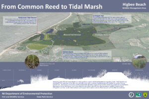 For managing flood risk from periodic storm surge events and future sea level rise, the project includes a 6,861-foot earthen berm system fitted with water control structures designed to control tidal inundation of eastern portions of the Higbee WMA along an alignment within the marsh that balances stakeholder objectives for restoring as much salt marsh as possible, while protecting freshwater habitat and groundwater resources. The top of the eastern berm elevation was set to 7.5 feet which was deemed appropriate given the design goal of providing a reasonable level of tidal inundation protection to the upper watershed, considering the landscape context and regional flooding pathways.
To provide targeted habitat control for migratory birds, an 851-foot-long northern berm along a northern finger of the Pond Creek marsh was incorporated with an elevation of 6.5 feet. This section of marsh will be restored through excavation, removal of Phragmites, and planting of native salt marsh species. Water levels within the northern marsh will be managed by NJDEP during short periods of target bird migration using a water control structure with flap gates. The structure can be set to allow tidal inundation ponding or the draining of the area behind the berm to provide tidal marsh, open water, and/or mudflat habitats.
Existing uplands within the project area are predominately covered with non-native species and patches of barren land where compacted, high pH materials from the former Harbison Walker Magnesite facility are exposed. The proposed upland habitat consists of a mix of maritime forest and coastal successional/old field habitat. Dune restoration will be constructed by placing the excavated marsh material and capping it with 2 feet of clean sand. Additionally, portions of the former Harbison Walker Magnesite facility and the northern landfill within the project area will be re-graded and topped with a 6-inch layer of topsoil, which will be seeded and restored into coastal successional/old field habitat. In addition to the upland habitat restoration, the project has incorporated dune restoration and channel reinforcement at localized points and low spots around a key freshwater habitat known as Davey’s Lake located near the beach front of the project area.
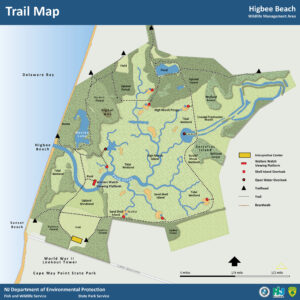 Multiple wildlife viewing structures will be incorporated along an enhanced trail system to provide visitors with an array of visual opportunities. The wildlife viewing structures include a bunker blind, a heron canopy viewing platform, two boardwalk systems with platforms, and several 360º bird blind structures. Additional trail enhancements include a connective loop around the project area that utilizes the berm system to provide access through the marsh, a new pedestrian bridge spanning across the mainstem of Pond Creek, and pedestrian benches and interpretive signs for public education opportunities.
Updates regarding construction progress will be posted on a quarterly basis.