 Official Site of The State of New Jersey
VISIT THE WMA EXPLORER
Explore the diverse array of resources at New Jersey’s Wildlife Management Areas with our latest app.
WMA OF THE MONTH
WMA OF THE MONTH
BLACK RIVER WMA
WMA Restrictions Are In Effect In the Following Areas:
| WMA | RESTRICTIONS IN EFFECT |
|---|---|
| Capoolong Creek WMA | Trail Closed to all activity including but not limited to hiking, walking, bike riding and horse back riding from White Bridge Road to Upper Kingtown Road. The area is closed because of hazardous trail conditions resulting from washouts and erosion. |
| Cedar Lake WMA | Sand Plant Area |
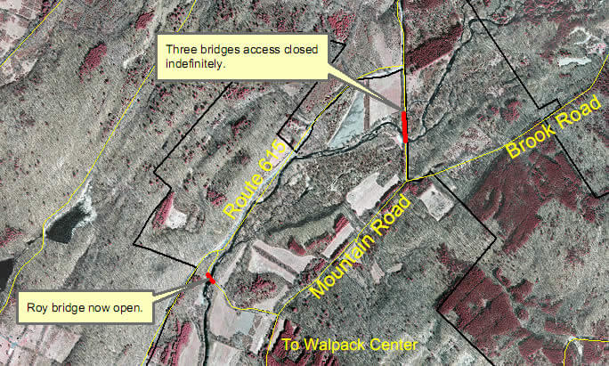
| Flatbrook-Roy WMA | The Three Bridges area on Mountain Road within the Flatbrook-Roy Wildlife Management Area is closed to vehicular traffic indefinitely. The decision to close the road was made based on concerns from Department of Transportation engineers regarding the structural integrity of the bridges. Sportsmen can still access this area via foot and can park along Mountain Road before the bridge closures, and can also use alternate routes via Roy Bridge on Rt. 615 or Brook Road from Route 560. (View map ) |
| Greenwood Forest WMA | Parkers Pit Area and Clay Holes Area |
| Higbee Beach WMA | Portions of Higbee Beach Wildlife Management Area (WMA) closed starting January 29th, 2024, for the Pond Creek Restoration Project. The closed portions of Higbee Beach WMA shall remain closed until the Restoration Project is completed in approximately December 2026. This closure is for public safety reasons and to protect and preserve the land and water areas of Higbee Beach WMA. For more information about the Pond Creek Restoration Project, please visit please visit the Higbee Beach Wildlife Management Area Tidal Marsh/Upland Restoration Project webpage. |
| Ken Lockwood Gorge | Middle Parking Area Closed |
| Malibu Beach WMA | Limited parking on property. Absolutely “No Parking” along Ocean Drive on either side of the road. All vehicles will be towed if found parked on Ocean Drive. Small Triangle to North of Main Parking Lot also closed. |
| Menantico Ponds WMA | Area 1 , Area 2 , and Area 3 The closed areas for Menantico Ponds WMA have changed from previous years. Please see the newest closure maps. |
| Wildcat Ridge WMA | Area in Splitrock Reservoir known as “The Cliffs” |
| Winslow WMA | Winslow East (Hot Mix) Area |
Wildlife Management Area Regulations
Wildlife Management Area Permits
WMA Habitat Management Projects
- Information on prescribed burns on WMAs is found on the State Forestry Service website.
- The Three Bridges area on Mountain Road within the Flatbrook-Roy Wildlife Management Area is closed to vehicular traffic indefinitely. The decision to close the road was made based on concerns from Department of Transportation engineers regarding the structural integrity of the bridges. The area is accessible via foot and parking is along Mountain Road before the bridge closures. The public can also use alternate routes via Roy Bridge on Rt. 615 or Brook Road from Rt. 560. (View map)
The table below lists all state Wildlife Management Areas (WMAs) as of September 2022. At that time the system had more than 357,000 acres in 122 areas. Additions to existing properties are continually being added. Additionally, Public Service Electric & Gas (PSE&G) maintains four (4) areas for public fish and wildlife associated recreation activities under the terms of State of New Jersey hunting and fishing permits. See below.
Clicking on a WMA name opens the WMA Explorer application and zooms to the selected WMA. The application lets users explore the diverse array of resources at New Jersey WMAs which consist of hundreds of thousands of acres of public lands with shooting ranges, dog training areas, boat ramps, fishing access sites, roads, parking areas and more available to hunters, trappers, anglers and other fish, wildlife and outdoor enthusiasts. The WMA Explorer provides general information about the WMA such as the wildlife and plant species that may be found there, the habitat types present and hunting and trapping zone information for a particular WMA. It also allows users to share and print maps they make with the application.
Please note that state WMAs and facilities are “carry-in – carry out” and trash receptacles are not Please note that state WMAs and facilities are “carry in – carry out” and trash receptacles are not provided; please plan accordingly to not leave any trash or recyclable behind.
For any questions relating to Wildlife Management Areas, please e-mail NJLandmanagement@dep.nj.gov.
| Name of Tract | County | Acreage Acquired by Fish and Wildlife | Acreage Acquired Through 1961-2009 Green Acres Bond Act | Acreage Acquired Through Waterfowl Stamp Program | Total Acreage as of February, 2021 |
|---|---|---|---|---|---|
| Abbotts Meadow | Salem | 1,533.67 | 84.33 | 1,618.00 | |
| Absecon | Atlantic | 2,910.20 | 978.99 | 56.81 | 3,946.00 |
| Alexauken Creek | Hunterdon | 689.00 | 689.00 | ||
| Alpha Grasslands Preserve | Warren | 128.00 | 128.00 | ||
| Amwell Lake | Hunterdon | 21.66 | 63.34 | 85.00 | |
| Andaloro | Gloucester | 53.00 | 53.00 | ||
| Assunpink | Monmouth | 6,410.00 | 6,410.00 | ||
| Baldwin Lake | Mercer | 36.94 | 10.06 | 47.00 | |
| Bear Swamp | Sussex | 2,993.00 | 2,993.00 | ||
| Beaver Brook | Warren | 686.00 | 686.00 | ||
| Beaver Swamp | Cape May | 2,931.00 | 2,931.00 | ||
| Belvidere Access | Warren | 7.00 | 7.00 | ||
| Berkshire Valley | Morris | 1,147.00 | 1,002.00 | 2,149.00 | |
| Black River | Morris | 3,083.00 | 3,083.00 | ||
| Buckhorn Creek | Warren | 898.00 | 898.00 | ||
| Buckshutem | Cumberland | 4,222 | 4,222 | ||
| Budd Lake | Morris | 80.00 | 80.00 | ||
| Butterfly Bogs | Ocean | 103.19 | 62.81 | 166.00 | |
| Cape Island | Cape May | 7.86 | 316.13 | 97.01 | 421.00 |
| Cape May Coastal Wetlands | Cape May | 876.42 | 13,856.00 | 3,192.581 | 17925.00 |
| Capoolong Creek | Hunterdon | 73.00 | 73.00 | ||
| Cedar Lake | Atlantic/Gloucester | 360.00 | 360.00 | ||
| Cedarville Ponds | Cumberland | 42.00 | 42.00 | ||
| Clarks Pond | Cumberland | 163.88 | 96.12 | 260.00 | |
| Clinton | Hunterdon | 850.00 | 1,214.00 | 2,064.00 | |
| Cohansey River | Cumberland | 1,474.00 | 1,474.00 | ||
| Colliers Mills | Ocean | 9,688.18 | 3,279.82 | 12,968.00 | |
| Columbia | Warren | 1,098.00 | 1,098.00 | ||
| Cox Hall Creek | Cape May | 316.00 | 316.00 | ||
| Culvers Brook Access | Sussex | 8.00 | 8.00 | ||
| Dennis Creek | Cape May | 1,325.85 | 6,876.00 | 544.15 | 8,746.00 |
| Dix | Cumberland | 913.17 | 4,394.83 | 149.00 | 5,457.00 |
| D.O.D. Ponds | Salem | 336.00 | 336.00 | ||
| Egg Island | Cumberland | 6,247.75 | 2,585.23 | 159.02 | 8,992.00 |
| Elmer Lake | Salem | 172.50 | 213.50 | 386.00 | |
| Featherbed Lane | Salem | 191.00 | 191.00 | ||
| Flatbrook/Roy | Sussex | 2,093.00 | 2,093.00 | ||
| Forked River Mt. | Ocean | 2,990.00 | 2,990.00 | ||
| Fortescue | Cumberland | 1,813.6 | 137.40 | 1,951 | |
| Glassboro | Gloucester | 2,341.95 | 51.05 | 2,393.00 | |
| Great Bay Boulevard | Ocean | 3,789.63 | 1,743.04 | 449.33 | 5,982.00 |
| Great Egg Harbor River | Atlantic | 7,560.00 | 7,560.00 | ||
| Greenwood Forest | Burlington/Ocean | 9,863.37 | 22,389.63 | 32,253.00 | |
| Gum Tree Corner | Salem/Cumberland | 1,217.96 | 13.04 | 1,231.00 | |
| Hackettstown | Warren | 231.24 | 6.76 | 238.00 | |
| Hainesville | Sussex | 281.50 | 467.50 | 749.00 | |
| Hamburg Mountain | Sussex | 2,357.60 | 1,334.40 | 3,692 | |
| Hammonton Creek | Atlantic | 5,720 | 5,720 | ||
| Harmony Access | Warren | 27.00 | 27.00 | ||
| Harrisonville Lake | Salem/Gloucester | 298.00 | 298.00 | ||
| Heislerville – Video | Cumberland | 2,680.07 | 3,459.00 | 1,560.00 | 7,700.00 |
| Higbee Beach* | Cape May | 196.00 | 967.00 | 1,163.00 | |
| Holland Church Access | Warren | 21.00 | 21.00 | ||
| Honey Run | Warren | 134.00 | 134.00 | ||
| Hummers Beach Access | Warren | 3.00 | 3.00 | ||
| Imlaystown Lake | Monmouth | 30.00 | 30.00 | ||
| Ken Lockwood Gorge | Hunterdon | 109.00 | 454.00 | 563.00 | |
| Knowlton Access | Warren | 14.00 | 14.00 | ||
| Little Flatbrook Access | Sussex | 7.00 | 7.00 | ||
| Lizard Tail Swamp Preserve***** | Cape May | 379.00 | 379.00 | ||
| Lockatong | Hunterdon | 765.00 | 765.00 | ||
| Logan Pond | Gloucester | 11.95 | 102.05 | 114.00 | |
| Mad Horse Creek | Salem | 4,409.65 | 4,531.75 | 573.6 | 9,515.00 |
| Makepeace Lake | Atlantic | 11,750.00 | 11,750.00 | ||
| Malibu Beach | Atlantic | 257.00 | 257.00 | ||
| Manahawkin | Ocean | 964.96 | 826.04 | 1,791.00 | |
| Manasquan River | Ocean/Monmouth | 744.00 | 744.00 | ||
| Manchester | Ocean | 2,300.00 | 1,502.00 | 3,802.00 | |
| Mantua Creek | Gloucester | 107.00 | 107.00 | ||
| Maple Lake | Atlantic | 4,797.00 | 4,797.00 | ||
| Maskells Mill Pond | Salem | 56.90 | 1,099.10 | 1,156.00 | |
| Medford | Burlington | 214.00 | 214.00 | ||
| Menantico Ponds | Cumberland | 295.90 | 1,525.10 | 1,821.00 | |
| Millville (Bevan) | Cumberland | 11,724.63 | 4,709.74 | 102.63 | 16,537.00 |
| Musconetcong River | Hunterdon/Morris/Warren | 1,648 | 1,648 | ||
| Nantuxent | Cumberland | 787.36 | 119.80 | 237.84 | 1,145.00 |
| Navesink River | Monmouth | 67.00 | 67.00 | ||
| New Sweden | Cumberland | 817.96 | 740.73 | 1,327.31 | 2,886.00 |
| Oyster Creek Access | Ocean | 14.00 | 14.00 | ||
| Paulinskill River Hyper Humus Easement | Sussex | 2,802.00 | 2,802.00 | ||
| Peaslee | Cumberland/Cape May | 9,642.78 | 19,927.22 | 29,570.00 | |
| Pemberton Lake | Burlington | 82.00 | 82.00 | ||
| Penbryn Pond | Camden | 355.00 | 355.00 | ||
| Pennsauken Access | Camden | 1.00 | 1.00 | ||
| Pequest | Warren | 203.66 | 5,305.34 | 5,509.00 | |
| Pleasant Run | Burlington/Mercer/Monmouth | 701.00 | 701.00 | ||
| Pohatcong Creek | Warren | 130.00 | 130.00 | ||
| Point Pleasant Fishing Access | Ocean | 7.00 | 7.00 | ||
| Pork Island | Atlantic | 616.84 | 251.16 | 868.00 | |
| Port Republic | Atlantic | 1,549.00 | 1,549.00 | ||
| Prospertown Lake | Ocean/Monmouth | 122.17 | 962.83 | 1,085.00 | |
| Raccoon Creek | Gloucester | 242.00 | 242.00 | ||
| Rainbow Lake | Salem | 196.00 | 196.00 | ||
| Ratzman Access | Warren | 7.00 | 7.00 | ||
| Rockaway River | Morris | 3,844.00 | 3,844.00 | ||
| Rockport – Pheasant Farm | Warren | 369.81 | 1,109.19 | 1,479.00 | |
| Rowands Pond | Camden | 13.00 | 13.00 | ||
| Salem River | Salem | 3,343.00 | 3,343.00 | ||
| Sawmill Creek | Bergen/Hudson | 727.00 | 727.00 | ||
| Sedge Islands ****** | Ocean | 193.00 | 193.00 | ||
| Shark River Access (pdf, 203kb) | Monmouth | 1.00 | 1.00 | ||
| South Branch | Morris | 1,947.00 | 1,947.00 | ||
| Sparta Mountain | Sussex/Morris | 3,461.00 | 3,461.00 | ||
| Spicers Creek Access | Cape May | 4.70 | 13.30 | 18.00 | |
| Stafford Forge | Ocean | 12,597.00 | 12,597.00 | ||
| Swan Bay | Burlington | 3,365.20 | 581.8 | 3,947.00 | |
| Thundergut Pond | Salem | 2,515.00 | 2,515.00 | ||
| Trout Brook | Sussex | 2,126.00 | 2,126.00 | ||
| Tuckahoe (MacNamara) – Impoundment Restoration Video | Cape May/Atlantic | 12,377.00 | 4,999.51 | 1,417.489 | 18,794.00 |
| Turkey Swamp | Monmouth/Ocean | 1,500.00 | 2,509.00 | 4,009.00 | |
| Union Lake | Cumberland/Salem | 5,269.00 | 5,269.00 | ||
| Upper Barnegat Bay | Ocean | 384.30 | 42.70 | 427.00 | |
| Van Nest Refuge | Mercer | 98.00 | 98.00 | ||
| Wading River | Burlington | 159.00 | 159.00 | ||
| Walpack | Sussex | 388.00 | 388.00 | ||
| Weldon Brook | Sussex | 1,577.00 | 1,577.00 | ||
| White Lake | Warren | 984.00 | 984.00 | ||
| White Oak Branch | Gloucester | 2,949.00 | 2,949.00 | ||
| Whiting | Ocean | 1,190.89 | 21.11 | 1,212.00 | |
| Whittingham | Sussex | 1,951.00 | 1,951.00 | ||
| Wildcat Ridge | Morris | 6,359.00 | 6,359.00 | ||
| Winslow | Camden/Gloucester | 1,726.15 | 6,640.85 | 8,367.00 |
| Acreage Totals | 98,450.43 | 250,089.21 | 11,057.71 | 359,597.00 |
| * License from Department of Army for conservation and management of 196.00 acres | ||||
| ** Administered by Fish and Wildlife and New Jersey Meadowlands Commission through permit issued by Natural Resource Council | ||||
| *** D.O.D. Ponds leased from Department of Army for management purposes (25 yrs. from 1998) | ||||
| **** Alpha Grasslands Preserve – DEP has a 44% interest in this property | ||||
| ***** Fish and Wildlife co-owners of property with The Nature Conservancy | ||||
| ****** Sedge Islands Conservation Zone Management Agreement (pdf, 1.0mb) | ||||
| ******* Fish and Wildlife co-owners of property (867 acres) with the New Jersey Conservation Foundation and Sussex County |
The PSE&G properties (The Bayside Tract, Commercial Township Wetland Restoraiton Site, Maurice River Township Wetland Restoration Site and Cohansey River Wetland Restoration Site) are open for public fish and wildlife associated recreation activities.