 Official Site of The State of New Jersey
Whether on the local or statewide scale, the CHANJ Tools can help land managers, transportation planners, conservation groups, and the general public to visualize their place in New Jersey’s habitat connectivity puzzle and to take meaningful steps to preserve and restore important linkages for wildlife across our landscape.
Mapping
The CHANJ Mapping highlights important areas for habitat connectivity across New Jersey. These include large intact “Core” habitats and the best available “Corridors” between them. The CHANJ Mapping also identifies road segments which bisect habitats and are likely to pose problems for animal movement. Together, these Cores, Corridors, and Road Segments represent the most advantageous places to preserve and restore wildlife connectivity in New Jersey.
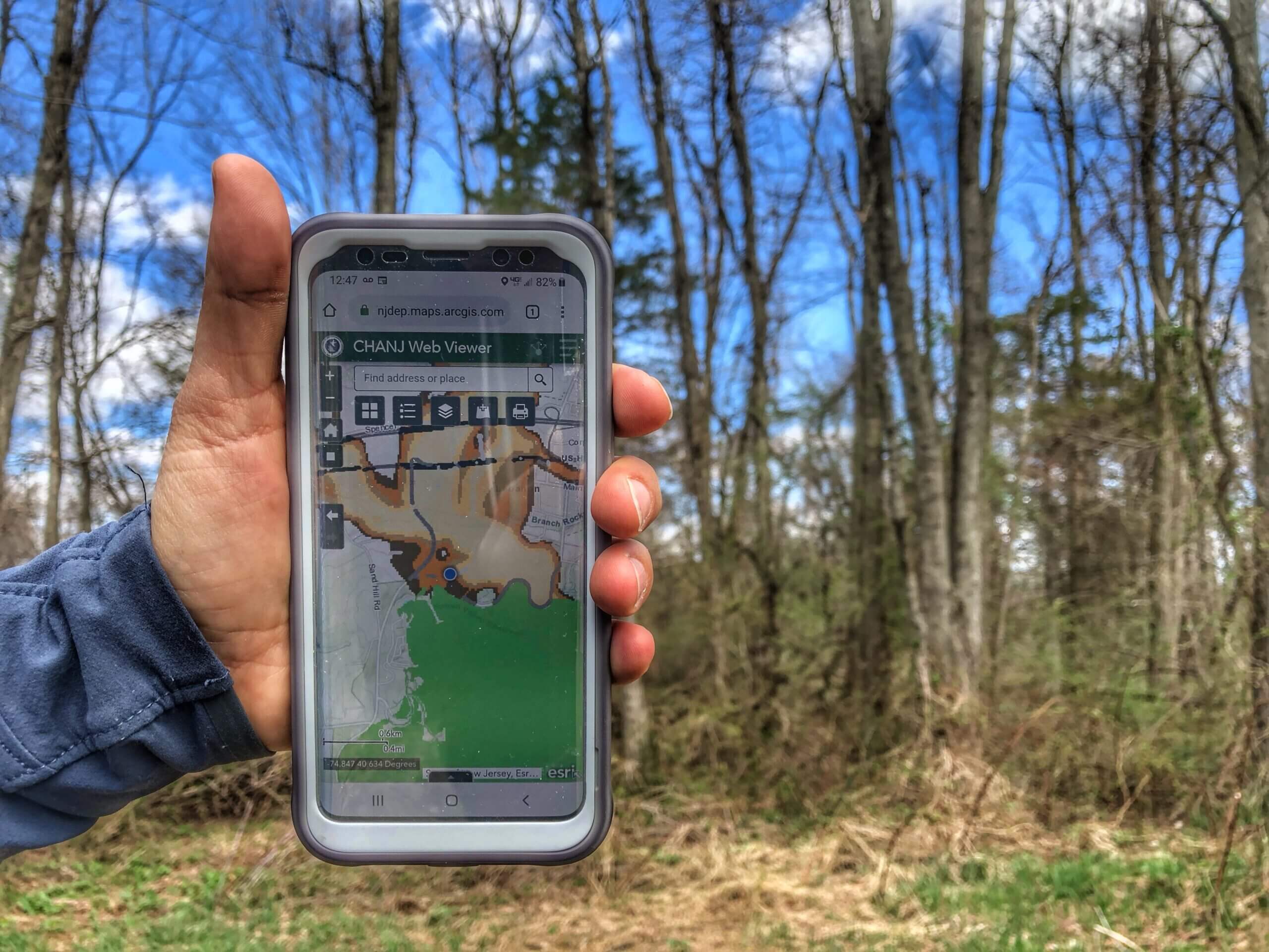
Access the Mapping via our online interactive CHANJ Web Viewer – it’s easy to use from any computer or mobile device. The Web Viewer is pre-loaded with various supplemental layers, like municipal and county boundaries, watersheds, water bodies, preserved lands, road-wildlife mitigation project locations and several aerial imagery and basemap options. Bookmark the CHANJ Web Viewer page or add it to your Home Screen for quick access.
A complete description of the CHANJ Mapping – including goals, supplemental layers, and the methodology used to create it – is found in Chapter 2 of the Guidance Document (see below).
The CHANJ layers are also available to GIS users:
1. Download the layers from the NJDEP Bureau of GIS CHANJ menu , or
2. Add the layers to your ArcMap project as Feature Services . From ArcMap Desktop, under “Add Data,” choose “Add Data From ArcGIS Online” and search for the layer by its name or its ArcGIS Online Item ID.
Not sure where to begin? A step-by-step CHANJ Mapping Tutorial video walks you through it.
A detailed User Guide and Quick Guide are also available in the Web Viewer’s “About” section (i).
Guidance Document
A companion to the CHANJ Mapping, our Guidance Document offers information and resources to help us all make strategic choices about preserving land, restoring habitat, and mitigating the effects of roads on wildlife.
Together, the CHANJ Mapping and Guidance Document can help steer a landscape strategy that preserves and maintains habitat connectivity for terrestrial wildlife across New Jersey, so that healthy populations can persist long into the future.

Guidance Document by Section
Looking for something specific? Zip right to it:
Cover pages and Executive Summary
Chapter 1. An Introduction to CHANJ
Chapter 2. CHANJ Mapping Tools
Chapter 3. Connectivity Assessments
Chapter 4. Guidance for CHANJ Cores and Corridors
—–Habitat Protection, Restoration, and Management
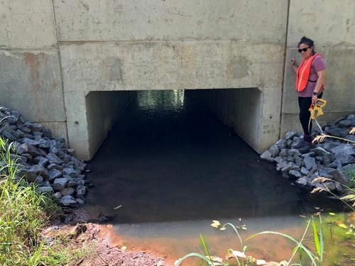
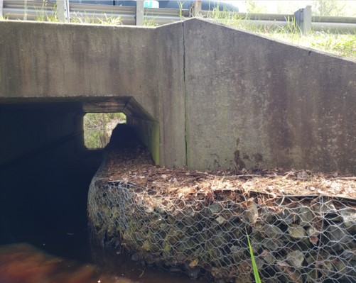
—–Road Mitigation Practices
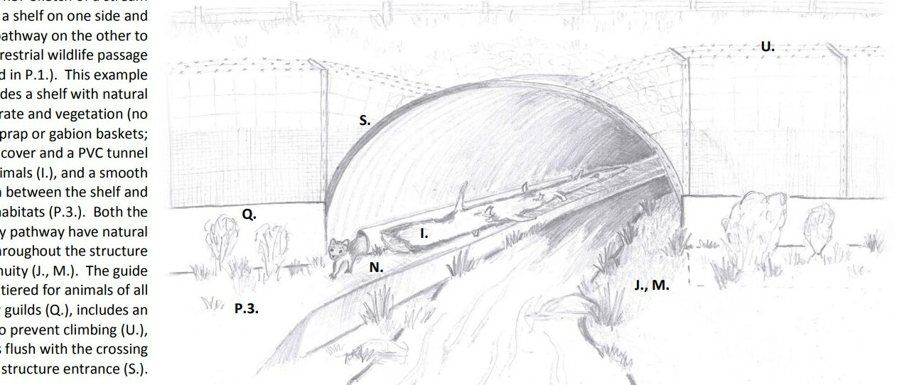
—–Best Practices for Wildlife Passage Systems
Chapter 5. CHANJ Action Teams
Appendices
—–I. Road Segment Report Outline
—–II. Road Segment Roadkill Survey Protocol
—–III. NAACC Culvert Inventory
—–IV. Photo Classification Protocol
NJ Wildlife Tracker
Help us identify problem spots for wildlife along NJ roadways! New Jersey Fish and Wildlife has released a new mobile-friendly web app – called NJ Wildlife Tracker – for reporting wildlife on roads as well as rare species sightings across the state. If you know of a roadkill/road-crossing hotspot, you can also email the CHANJ team so we can map it and perhaps gather more data. Visit NJFW’s Reporting Wildlife Sightings page to learn more about the species we are most interested in tracking.
Back to CHANJ home page