 Official Site of The State of New Jersey
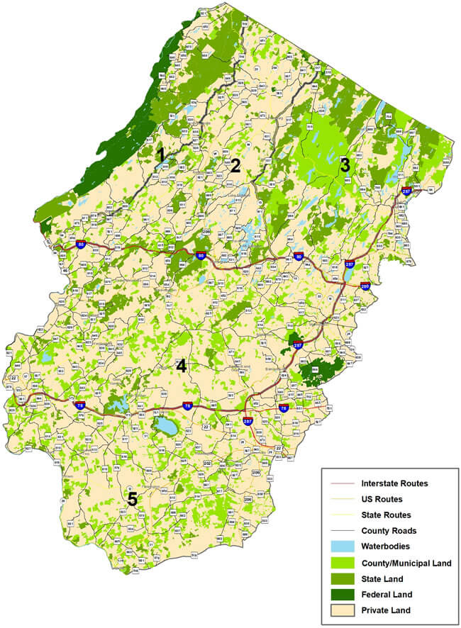
The map and text below describe the zones open for bear hunting by properly licensed hunters possessing a Black Bear Hunting Season Permit. Click on a zone for a large version of it, or view the enlarged overview map. Printable (pdf) versions of each zone are linked from the descriptions below.
|
Black Bear Hunting Zone No. 1:
That portion of Warren
and Sussex counties lying within a continuous line
beginning at the intersection of the Portland Bridge
and the Delaware River at Columbia; then northward
along the east bank of the Delaware River to the New
York State Line; then east along the New York State
Line to Rt. 519; then south along Rt. 519 to its intersection
with Rt. 627; then south along Rt. 627 to its
intersection with Rt. 626; then south along Rt. 626
to its intersection with Rt. 521; then southwest along
Rt. 521 to its intersection with Rt. 94 in Blairstown;
then southwest along Rt. 94 to the Portland Bridge,
the point of beginning in Columbia. The islands of
Labar, Tocks, Poxono, Depew, Namanock, Minisink
and Mashipacong lying in the Delaware River are also
included within this hunting Zone.
Zone 1 Map (pdf, 320kb) |
Black Bear Hunting No. Zone 2: That portion of Sussex,
Warren and Morris counties lying within a
continuous line beginning at Portland Bridge in
Columbia; then northward along Rt. 94 to its intersection
with Rt. 521 in Blairstown; then north along
Rt. 521 to its intersection with Rt. 626; then north
along Rt. 626 to its intersection with Rt. 627; then
north along Rt. 627 to its intersection with Rt. 519
in Branchville; then north along Rt. 519 to the New
York State Line; then southeast along the New York
State line to Rt. 517; then south along Rt. 517 to its
intersection with Rt. 94; then south on Rt. 94 to its
intersection with Rt. 23 in Hamburg Borough; then
south along Rt. 23 to its intersection with Rt. 517 in
Franklin; then south along Rt. 517 to its intersection
with Rt. 15 in Sparta; then south along Rt. 15 to its
intersection with Interstate 80 in Dover; then west
along interstate 80 to its intersection with Rt. 94;
then south along Rt. 94 to the intersection with the
Portland Bridge and the Delaware River located in
Columbia, the point of beginning.
Zone 2 Map (pdf, 480kb) |
Black Bear Hunting Zone No. 3: That portion of Sussex,
Passaic, Morris, and Bergen counties lying
within a continuous line beginning at the intersection
of Rt. 80 and Rt. 15 in Dover; then north along Rt. 15
to its intersection with Rt. 517 in Sparta; then north
along Rt. 517 to its intersection with Rt. 23 in Franklin;
then north along Rt. 23 to its intersection with
Rt. 94 in Hamburg Borough; then north along Rt.
94 to its intersection with Rt. 517; then north along
Rt. 517 to the New York State Line; then east along
the New York State Line to its intersection with Rt.
287; then south along Rt. 287 to its intersection with
Rt. 80; then west along Rt. 80 to its intersection with
Rt. 15 the point of beginning in Dover.
Zone 3 Map (pdf, 465kb) |
Black Bear Hunting Zone No. 4: That portion of Sussex,
Warren, Morris, Somerset and Hunterdon
counties lying within a continuous line beginning at
the intersection of Route 78 and the Delaware River;
then north along the east bank of the Delaware River
to the Portland Bridge at Columbia; then northeast
along Rt. 94 to its intersection with Rt. 80; then east
along Rt. 80 to its intersection with Rt. 287; then
southwest along Rt. 287 to its intersection with Rt.
78; then west along Rt. 78 to the Delaware River the
point of beginning.
Zone 4 Map (pdf, 595kb) |
Black Bear Hunting Zone No. 5: That portion of Bergen, Hunterdon,
Mercer, Morris, Passaic, Somerset, and Warren
counties lying within a continuous line beginning
at the intersection of Rt. 78 and the Delaware River;
then east along Rt. 78 to its intersection with Rt.
287; then northeast along Rt. 287 to its intersection
with Rt. 202 in Oakland; then south along Rt. 202
to its intersection with Rt. 23; then south along Rt.
23 to its intersection with Rt. 80; then west along
Rt. 80 to its intersection with the Passaic River;
then west along the north bank of the Passaic River
to its intersection with Rt. 80; the west on Rt. 80
to its intersection with Rt. 280; then south along
Rt. 280 to its intersection with Rt. 632; then south
along Rt. 632 to its intersection with Rt. 608; then
south along Rt. 608 to its intersection with Rt. 124;
then southeast along Rt. 124 to its intersection with
Rt. 638; then south along Rt. 638 to its intersection
with Rt. 531; then south along Rt. 531 to its intersection
with Rt. 527; then south along Rt. 527 to its
intersection with Rt. 533; then south along Rt. 533
to its intersection with Rt. 206; then south along
Rt. 206 to its intersection with Rt. 518; then west
along Rt. 518 to its intersection with Rt. 165; then
west along Rt. 165 to its intersection with Rt. 179;
then west along Rt. 179 to the Delaware River; then
north along the east bank of the Delaware River to
its intersection with Rt. 78, the point of beginning.
Zone 5 Map (pdf, 440kb) |