In This Report:
Contact Us:
Environmental Trends Report
NJDEP, Division of Science and Research

Estuarine Algal Conditions
Background
The Department of Environmental Protection monitors for harmful algal blooms in estuarine and marine waters. This monitoring is required by the National Shellfish Sanitation Program to protect public health from adverse health effects that can occur from consuming algal contaminated shellfish. In addition to effects related to consumption of contaminated shellfish, algal blooms can also cause fish kills, mild toxicity to bathers, and discoloration of water. Certain algal species can produce various tide colors (e.g., red, green, or brown) when found in sufficient density. The most harmful public-health related effects are generally associated with some algal species that produce red tides, but not all red tides have toxins or are harmful. Certain red tide algal species are a public health concern as they can result in paralytic shellfish poisoning and diarrhetic shellfish poisoning. Amnesiac shellfish poisoning, also a public health effect of concern, results from an algal species that produces a brown tide. In addition to affecting human health, algal blooms can be detrimental to ecological health when the algae die and are degraded by bacteria, consuming oxygen in the water column. This oxygen depletion can cause physical stress or even mortality to fish and other marine life.
Since 1978, microscopic analysis of state water samples has identified the presence of toxic algal species below concentrations that would threaten public health. In the early 2000s, brown tide blooms caused by the organism Aureococcus anophagefferens, were evident in the Barnegat Bay/Little Egg Harbor Estuary.1 Every year since 2004, the Barnegat Bay/Little Egg Harbor Estuary has experienced blooms of Nannochloris sp. during the summer months. Nannochloris sp. creates a yellowish-brown tide that is not considered toxic and primarily reduces the aesthetic quality of the water. In recent years, blooms caused by both diatoms and dinoflagellates have been found in the Hudson-Raritan Estuary, causing red, brown, and green water discolorations, however no toxin-producing algal species were present.
Sampling and Analysis
Phytoplankton identification and composition and chlorophyll a analysis are two of the primary measurements used to determine algal conditions. Chlorophyll a is a plant pigment used to determine the amount of algal biomass present in a body of water and can help determine areas that need to be watched for harmful algal blooms. Currently, the Bureau of Marine Water Monitoring collects water samples for both ecological and public health purposes. Collection covers all estuarine waters from the Raritan Bay to the Delaware Bay, up to the points beyond tidal influence (head of tide). Excessive amounts of chlorophyll a indicate an algal bloom that may reduce water clarity and may result in depleted dissolved oxygen levels.
DEP conducts monitoring for algal blooms using three complementary approaches. The three methods used include discrete sampling, aircraft remote sensing, and continuous sampling from buoys.
Discrete sample collection is the primary sampling method going back to 1998. Currently, surface water quality grab samples are collected at 55 stations once every month. The stations represent the major estuarine waterbody types, tidal river/tributaries, shallow estuaries, and river dominated estuaries. The samples are analyzed in a DEP lab for nutrients, phytoplankton identification, and levels of chlorophyll a. Results from discrete sampling are summarized in Figure 1 below.
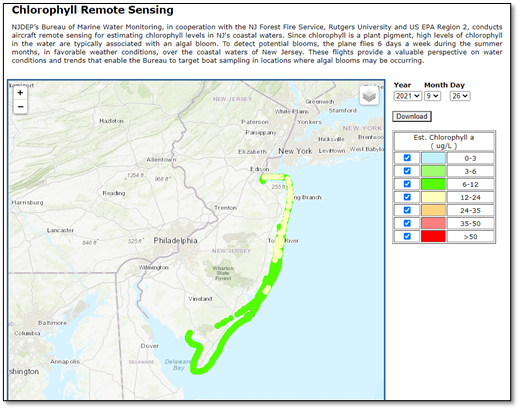
The second method is aircraft remote sensing, which began in 2007. This program utilizes a hyperspectral sensor fixed on an airplane which flies over estuarine waters while recording wavelengths specific for chlorophyll. The color of waterbodies is indicative of algal presence and specific shades can be correlated with chlorophyll a concentration. Any blooms over 24 µg/L are flagged for targeted sampling. An example of the results from one remote sensing flight is shown in Figure 2.
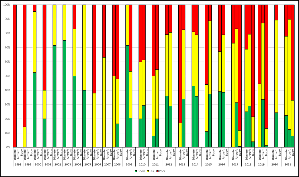
The third sampling program collects continuous data from eight buoys, five in the Barnegat Bay estuary, two in the Raritan/Sandy Hook Bay area, and one in the Navesink River (Figures 3-4). These buoys are used to validate the aircraft sensor data, to monitor the daily fluctuations in the algal biomass, and to monitor the changes and status of algal blooms when present.
Status and Trends
Discrete Sampling: Algal bloom conditions are determined by routine chlorophyll a measurements.2 An algal bloom is defined as a chlorophyll concentration of twice the long-term mean or greater than 20 micrograms per liter (µg/L) within one of 77 hexagonal monitoring units. The coastal estuarine hexagons are 30.6 square miles and the larger hexagons that encompass Raritan and Delaware Bay are 65.5 square miles. In this marine ambient water quality monitoring program, chlorophyll concentrations are routinely measured in these 77 hexagons covering 100% of the state’s estuarine waters.
The chart “Algal Conditions in New Jersey Estuarine Waters (1998 – 2021)” (Figure 1) shows the percentage of hexagons in New Jersey’s monitored estuarine waters per year that experienced at least one bloom based on sampling within the hexagons. For example, at least one bloom was observed in 7% of the representative hexagons in 2021. The sampling design does not allow for continuous monitoring of all estuarine waters; therefore, the absolute frequency of algal blooms cannot be determined. “No data” indicates when samples were not collected in certain areas either due to weather, or in the case of 2009 and 2010, priority monitoring changes. For example, in 1998, 12% of estuarine waters were not sampled.
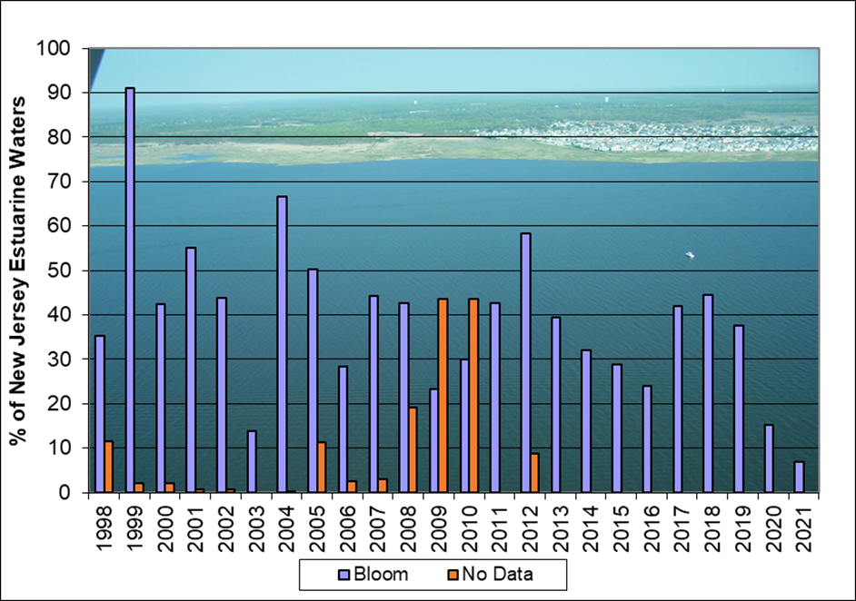
As can be seen, bloom conditions can vary dramatically from year to year, ranging from an occurrence in over 90% of hexagons in 1999 to 7% of hexagons in 2021. Among the factors that may influence this trend are inter-annual changes in rainfall, offshore phytoplankton conditions, changes in nutrient loadings into these coastal waters, meteorological factors of wind and cloud cover, air and water temperatures, and the number of locations monitored.
Aircraft Remote Sensing: Coastal remote sensing flights are conducted weekly to detect levels of chlorophyll a in March through May, then six days a week between Memorial Day and Labor Day, and again weekly September through November. The purpose of these flights is to cover large areas of the state to identify any algal blooms and their location for further sampling and species identification. All data is posted daily at: https://njdep.rutgers.edu/aircraft/. Figure 2 shows an image of a flight from September 26, 2021. This flight takes approximately 2.5 hours and the color indicates the chlorophyll a concentration. If concentrations are elevated above 24 µg/L in one area for two consecutive days, water samples will be collected and species identification performed.
Comparison of Estuaries from Ambient Monitoring, Aircraft Remote Sensing, and Continuous Water Quality Monitoring
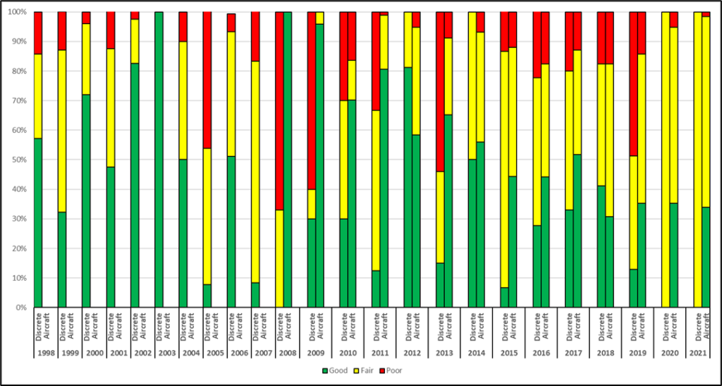
Since 1998, water samples have been collected by boat at predetermined, fixed stations as part of the NJDEP Marine Water Routine Ambient Nutrient Monitoring Program. All the samples from these fixed station programs are analyzed for chlorophyll a throughout the Raritan/Sandy Hook Bay, Barnegat Bay, and Delaware Bay. Data is assessed using the threshold values and summertime (July-September) index period described in the USEPA National Coastal Condition Report IV.3 The threshold values are: less than 5 µg/l (Good), 5 – 15 µg/l (Fair), and greater than 15 µg/l (Poor).
Aircraft remote sensing was added to the monitoring program in 2007, greatly increasing the spatial coverage. The addition of continuous monitoring buoys subsequently filled temporal gaps for specific locations. DEP views the results of these three sampling programs together to provide the most comprehensive picture of estuarine algal conditions in New Jersey.
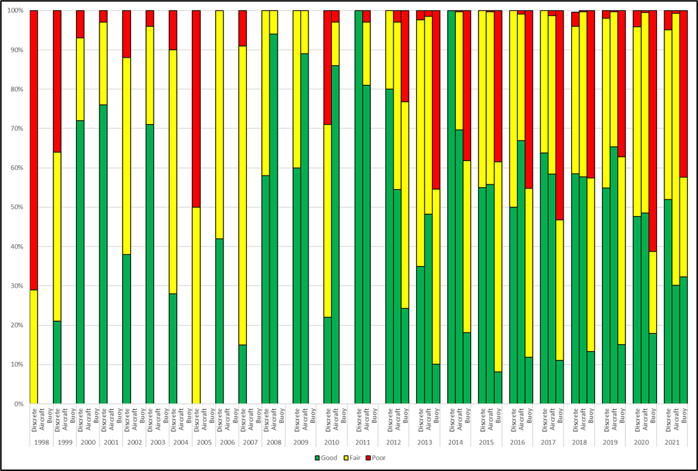
Continuous Monitoring: As can be seen in Figures 3, 4, and 5, chlorophyll a concentrations vary dramatically from year to year and from estuary to estuary among the Raritan/Sandy Hook Bay, Barnegat Bay, and Delaware Bay from 1998 – 2021. The NY/NJ Harbor and the Delaware Bay experience frequent algal blooms, especially after precipitation which increases nutrient loads. These two estuaries support economically important shellfish harvests that can be negatively impacted by algal blooms. Many factors, including those listed previously, can affect the algal concentrations. When comparing these three sampling methods, aircraft remote sensing assesses the greatest spatial extent with comprehensive coverage of estuarine waters from the Raritan/Sandy Hook Bay south to the Delaware Bay. Buoy sampling is continuous but only allows assessment of 8 fixed locations. Discrete sampling has a smaller spatial extent than aircraft remote sensing, but a greater extent than buoy monitoring and offers a longer dataset. The percentage of waters that falls within each threshold (good, fair, and poor) shows some agreement among sampling methods.
Where all three techniques are available, in Raritan/Sandy Hook Bay and Barnegat Bay, we can see that the continuous water quality sensors (buoy) detect poor chlorophyll a conditions more than the discrete and aircraft remote sensing data; this is due to the detection of higher chlorophyll due to an increase in algal productivity during the afternoon hours, aircraft and discrete data are collected in the morning hours when algal productivity is generally low. For these two waterbodies the discrete and aircraft data are generally closer in agreement, differences are due to point sample locations versus the spatial data from the aircraft. In the Delaware Bay the data shows that there are more waters ranked as fair and poor than detected by the aircraft, this is due to sampling stations for the discrete monitoring are in many cases located near tributary inputs that increase the algal density locally, where the aircraft flight path can vary and at times can be over offshore waters of the bay which are not seeing the impact from the tributaries. The compiled results of each method, where available, are shown in the figures below.
Outlook and Implications
Algal blooms routinely occur in areas with nutrient over-enrichment. Dense algal blooms can block sunlight for aquatic plants and cause oxygen depletion, stressing marine organisms. As climate change drives increases in air and water temperatures, conditions become more favorable for algae. In the presence of elevated nutrients, warmer water temperatures are associated with more frequent and severe algal blooms.
Near shore algal blooms are typically associated with ocean upwelling which brings nutrient rich waters from the ocean floor to the surface. Unlike estuarine blooms, these blooms are not associated with anthropogenic nutrient loads. The use of statewide remote sensing has found that algal blooms can be very small in areal coverage and has allowed for targeted sampling of waters to identify algal species.
It is important to control nutrient loadings from fertilizer and treated sewage to protect aquatic life such as fish and shellfish. In 2011, the state enacted the NJ Fertilizer Law, which has a three-pronged approach.4 It requires the use of best management practices to reduce the impacts of fertilizers on waterways, a certification program for professional fertilizer applicators, and the reformulation of fertilizers to contain at least 20% slow-release nitrogen and 0% phosphorus (unless a soil test demonstrates a need for phosphorus to be added). In addition, there are annual blackout dates for fertilizer use where homeowners may not apply fertilizer between November 15 and March 1, and commercial applicators may not apply fertilizer between December 1 and March 1. In order to address nutrient loadings from sewage treatment plants, the Department imposes effluent limitations for phosphorus and nitrogen in wastewater permits when appropriate.
Estuarine algal blooms can have negative impacts on aquatic vegetation, marine fauna, and the shellfishing industry. Algal blooms have the potential to reduce water clarity, cutting down on the sunlight available to aquatic vegetation. When algae die off, the bacteria that degrade them deplete oxygen from the water column. Low dissolved oxygen conditions do not support a healthy assemblage of marine life. Further, shellfish contamination by certain algae can be dangerous for human health and economically devastating to the shellfish industry. DEP continues to monitor chlorophyll a through discrete sampling, aircraft remote sensing, and continuous buoy measurements in order to prevent human health impacts and to inform its efforts in reducing nutrient inputs into our waterways.
More Information
Additional information can be obtained by contacting NJDEP’s Bureau of Marine Water Monitoring at (609) 748-2000 or by visiting www.nj.gov/dep/bmw. Remote sensing data can be accessed directly at: http://njdep.marine.rutgers.edu/aircraft/.
References
1Gastrich, M. D.; R. Lathrop, S. Haag, M.P. Weinstein, M. Danko, D. A. Caron, R. Schaffner. 2004. Assessment of brown tide blooms, caused by Aureococcus anophagefferens, and contributing factors in New Jersey coastal bays: 2000-2002. Harmful Algae, Special issue: Brown Tides – Edited by M. Lomas and C. Gobler. Vol 3: 305-320.
2Cosper, E.M. 1995. Assessment of Historical Phytoplankton Characteristics and Bloom Phenomena in the New York Harbor Estuarine and New York Bight Ecosystems. Preliminary Report. E.M. Cosper, Coastal and Environmental Studies, Inc., Bohemia, NY. May 4, 1995.
3United States Environmental Protection Agency, Office of Research and Development/Office of Water, EPA 842-R-10-003, April 2012.
4New Jersey Department of Environmental Protection, Healthy Lawns Healthy Water, https://www.nj.gov/dep/healthylawnshealthywater/ Accessed October 2, 2023.