 OFFICIAL SITE OF THE STATE OF NEW JERSEY
A GIS-Based Tool for Spatial Planning of Shellfish Aquaculture in New Jersey
With support from the National Sea Grant program, a team of Rutgers University researchers, in partnership with the New Jersey Department of Environmental Protection’s Marine Resources Administration created a new online aquaculture siting tool that provides commercial shellfish industry members and resource managers with the best available data to support appropriate siting of commercial shellfish aquaculture in an easy-to-use map-based format.
Data can assist growers in understanding the regulatory constraints, potential user group conflicts, and physical characteristics of a site before applying for a shellfish lease.
- Find a specific site location on the map using the address or interactively by zooming and panning.
- Display various geospatial information related to that location by turning layers on or off.
- Click on a location and an information window will pop-up with relevant attributes pertaining to the location.
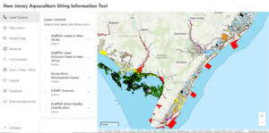
The tool is available and free online at NJ.Aquaculture.rutgers.edu